
Original file (3,000 × 2,000 pixels, file size: 4.75 MB, MIME type: image/jpeg)
| This is a file from the
Wikimedia Commons. Information from its
description page there is shown below. Commons is a freely licensed media file repository. You can help. |
Summary
| Description |
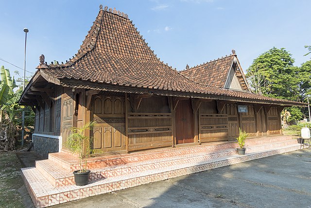
Bahasa Indonesia: Joglo Pencu merupakan rumah adat dari Kabupaten Kudus, Jawa Tengah. Salah satu ciri khas dari rumah adat ini adalah atapnya yang disebut “pencu”.
Joglo Pencu merupakan perpaduan dari gaya arsitektur budaya Jawa, Persia, Cina, dan Eropa. Model rumah ini diperkirakan mulai dibangun pada tahun 1500-an menggunakan bahan kayu jati asli. Tak hanya itu, di dalam rumah adat itu, terdapat berbagai ukiran sulur-suluran, mahkota, dan sejumlah relief binatang dan tumbuhan yang indah dipandang.English: Joglo Pencu is a traditional house from Kudus Regency, Central Java. One of the characteristics of this traditional house is the roof called "pencu".
Joglo Pencu is a blend of Javanese, Persian, Chinese and European architectural styles. This house model is estimated to have been built in the 1500s using real teak wood. Not only that, inside the traditional house, there are various carvings of tendrils, crowns, and a number of reliefs of animals and plants that are beautiful to look at. |
| Date | |
| Source | Own work |
| Author | Herusutimbul |
| Camera location |
| View this and other nearby images on: OpenStreetMap |
|
|---|
Licensing
- You are free:
- to share – to copy, distribute and transmit the work
- to remix – to adapt the work
- Under the following conditions:
- attribution – You must give appropriate credit, provide a link to the license, and indicate if changes were made. You may do so in any reasonable manner, but not in any way that suggests the licensor endorses you or your use.
- share alike – If you remix, transform, or build upon the material, you must distribute your contributions under the same or compatible license as the original.

|
This photo was uploaded to Wikimedia Commons as part of a photography contest
WikiKaleidoskop
organized by Wikimedia Indonesia with the support of the Wikimedia Foundation. |
File history
Click on a date/time to view the file as it appeared at that time.
| Date/Time | Thumbnail | Dimensions | User | Comment | |
|---|---|---|---|---|---|
| current | 03:31, 31 October 2021 |
| 3,000 × 2,000 (4.75 MB) | Herusutimbul | Uploaded own work with UploadWizard |
File usage
Global file usage
The following other wikis use this file:
- Usage on ban.wikipedia.org
- Usage on en.wikivoyage.org
- Usage on id.wikipedia.org
- Usage on jv.wikipedia.org
- Usage on ko.wikipedia.org
- Usage on ml.wikipedia.org
- Usage on www.wikidata.org
- Usage on zh.wikipedia.org
Metadata
Original file (3,000 × 2,000 pixels, file size: 4.75 MB, MIME type: image/jpeg)
| This is a file from the
Wikimedia Commons. Information from its
description page there is shown below. Commons is a freely licensed media file repository. You can help. |
Summary
| Description |
Bahasa Indonesia: Joglo Pencu merupakan rumah adat dari Kabupaten Kudus, Jawa Tengah. Salah satu ciri khas dari rumah adat ini adalah atapnya yang disebut “pencu”.
Joglo Pencu merupakan perpaduan dari gaya arsitektur budaya Jawa, Persia, Cina, dan Eropa. Model rumah ini diperkirakan mulai dibangun pada tahun 1500-an menggunakan bahan kayu jati asli. Tak hanya itu, di dalam rumah adat itu, terdapat berbagai ukiran sulur-suluran, mahkota, dan sejumlah relief binatang dan tumbuhan yang indah dipandang.English: Joglo Pencu is a traditional house from Kudus Regency, Central Java. One of the characteristics of this traditional house is the roof called "pencu".
Joglo Pencu is a blend of Javanese, Persian, Chinese and European architectural styles. This house model is estimated to have been built in the 1500s using real teak wood. Not only that, inside the traditional house, there are various carvings of tendrils, crowns, and a number of reliefs of animals and plants that are beautiful to look at. |
| Date | |
| Source | Own work |
| Author | Herusutimbul |
| Camera location |
| View this and other nearby images on: OpenStreetMap |
|
|---|
Licensing
- You are free:
- to share – to copy, distribute and transmit the work
- to remix – to adapt the work
- Under the following conditions:
- attribution – You must give appropriate credit, provide a link to the license, and indicate if changes were made. You may do so in any reasonable manner, but not in any way that suggests the licensor endorses you or your use.
- share alike – If you remix, transform, or build upon the material, you must distribute your contributions under the same or compatible license as the original.
|
|
This photo was uploaded to Wikimedia Commons as part of a photography contest
WikiKaleidoskop
organized by Wikimedia Indonesia with the support of the Wikimedia Foundation. |
File history
Click on a date/time to view the file as it appeared at that time.
| Date/Time | Thumbnail | Dimensions | User | Comment | |
|---|---|---|---|---|---|
| current | 03:31, 31 October 2021 |
| 3,000 × 2,000 (4.75 MB) | Herusutimbul | Uploaded own work with UploadWizard |
File usage
Global file usage
The following other wikis use this file:
- Usage on ban.wikipedia.org
- Usage on en.wikivoyage.org
- Usage on id.wikipedia.org
- Usage on jv.wikipedia.org
- Usage on ko.wikipedia.org
- Usage on ml.wikipedia.org
- Usage on www.wikidata.org
- Usage on zh.wikipedia.org