No higher resolution available.
JerseyCI_topograph1.PNG (668 × 509 pixels, file size: 29 KB, MIME type: image/png)
| This is a file from the
Wikimedia Commons. Information from its
description page there is shown below. Commons is a freely licensed media file repository. You can help. |
Summary
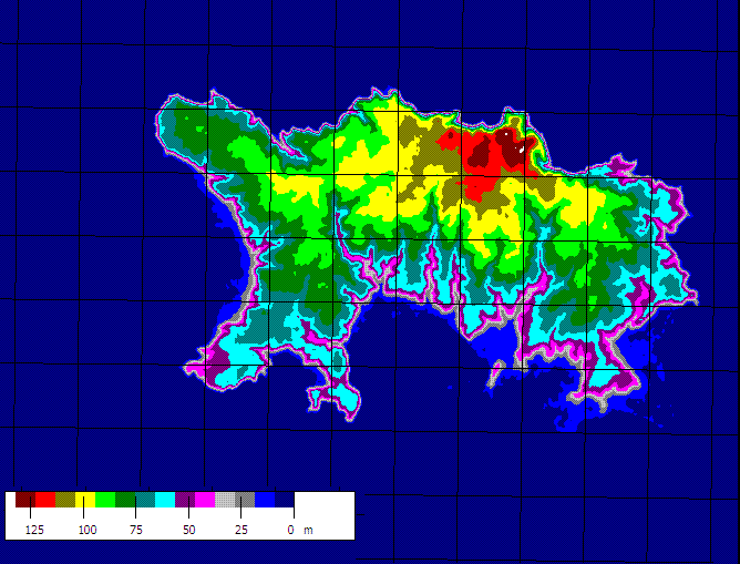
| Description | Topographic relief map of the Channel Island of Jersey. Produced from SRTM data using Microdem. Jaraalbe 08:07, 21 April 2006 (UTC) |
| Date | 21 April 2006 (original upload date) |
| Source | No machine-readable source provided. Own work assumed (based on copyright claims). |
| Author | No machine-readable author provided. Jaraalbe~commonswiki assumed (based on copyright claims). |
Licensing
| I, the copyright holder of this work, release this work into the
public domain. This applies worldwide. In some countries this may not be legally possible; if so: I grant anyone the right to use this work for any purpose, without any conditions, unless such conditions are required by law. |
File history
Click on a date/time to view the file as it appeared at that time.
| Date/Time | Thumbnail | Dimensions | User | Comment | |
|---|---|---|---|---|---|
| current | 08:07, 21 April 2006 |
| 668 × 509 (29 KB) | Jaraalbe~commonswiki | Topographic map of the Channel Island of Jersey. Produced from SRTM data using Microdem. ~~~~ |
File usage
The following pages on the English Wikipedia use this file (pages on other projects are not listed):
Global file usage
The following other wikis use this file:
- Usage on es.wikipedia.org
No higher resolution available.
JerseyCI_topograph1.PNG (668 × 509 pixels, file size: 29 KB, MIME type: image/png)
| This is a file from the
Wikimedia Commons. Information from its
description page there is shown below. Commons is a freely licensed media file repository. You can help. |
Summary
| Description | Topographic relief map of the Channel Island of Jersey. Produced from SRTM data using Microdem. Jaraalbe 08:07, 21 April 2006 (UTC) |
| Date | 21 April 2006 (original upload date) |
| Source | No machine-readable source provided. Own work assumed (based on copyright claims). |
| Author | No machine-readable author provided. Jaraalbe~commonswiki assumed (based on copyright claims). |
Licensing
| I, the copyright holder of this work, release this work into the
public domain. This applies worldwide. In some countries this may not be legally possible; if so: I grant anyone the right to use this work for any purpose, without any conditions, unless such conditions are required by law. |
File history
Click on a date/time to view the file as it appeared at that time.
| Date/Time | Thumbnail | Dimensions | User | Comment | |
|---|---|---|---|---|---|
| current | 08:07, 21 April 2006 |
| 668 × 509 (29 KB) | Jaraalbe~commonswiki | Topographic map of the Channel Island of Jersey. Produced from SRTM data using Microdem. ~~~~ |
File usage
The following pages on the English Wikipedia use this file (pages on other projects are not listed):
Global file usage
The following other wikis use this file:
- Usage on es.wikipedia.org