Photos • Location


Size of this preview:
800 × 540 pixels. Other resolutions:
320 × 216 pixels |
640 × 432 pixels |
900 × 608 pixels.
Original file (900 × 608 pixels, file size: 131 KB, MIME type: image/jpeg)
| This is a file from the
Wikimedia Commons. Information from its
description page there is shown below. Commons is a freely licensed media file repository. You can help. |
Summary
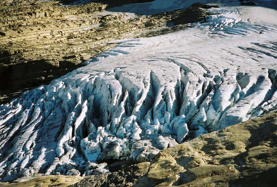
| Description | Image of the terminal end of Jackson Glacier in Glacier National Park (U.S.) |
| Source | United States Geological Survey...from the following link [1], enlarged at [2] |
| Author | USGS |
![[2]](https://www.nrmsc.usgs.gov/images/gcc/Jackson_terminus.jpg)
| Camera location | | View this and other nearby images on: OpenStreetMap |
|
|---|
Licensing
This image is in the
public domain in the United States because it only contains materials that originally came from the
United States Geological Survey, an agency of the
United States Department of the Interior. For more information, see
the official USGS copyright policy.
|
File history
Click on a date/time to view the file as it appeared at that time.
| Date/Time | Thumbnail | Dimensions | User | Comment | |
|---|---|---|---|---|---|
| current | 00:16, 20 January 2008 |
| 900 × 608 (131 KB) | MONGO | {{Information |Description=Image of the terminal end of Jackson Glacier in Glacier National Park (U.S.) |Source=United States Geological Survey...from the following link [http://www.nrmsc.usgs.g |
File usage
The following pages on the English Wikipedia use this file (pages on other projects are not listed):
Global file usage
The following other wikis use this file:
- Usage on as.wikipedia.org
- Usage on ceb.wikipedia.org
- Usage on cy.wikipedia.org
- Usage on el.wikipedia.org
- Usage on en.wikiversity.org
- Usage on eo.wikipedia.org
- Usage on fa.wikipedia.org
- Usage on fr.wikipedia.org
- Usage on fy.wikipedia.org
- Usage on hr.wikipedia.org
- Usage on hy.wikipedia.org
- Usage on ku.wikipedia.org
- Usage on nl.wikipedia.org
- Usage on sr.wikipedia.org
- Usage on ur.wikipedia.org
- Usage on www.wikidata.org
Size of this preview:
800 × 540 pixels. Other resolutions:
320 × 216 pixels |
640 × 432 pixels |
900 × 608 pixels.
Original file (900 × 608 pixels, file size: 131 KB, MIME type: image/jpeg)
| This is a file from the
Wikimedia Commons. Information from its
description page there is shown below. Commons is a freely licensed media file repository. You can help. |
Summary
| Description | Image of the terminal end of Jackson Glacier in Glacier National Park (U.S.) |
| Source | United States Geological Survey...from the following link [1], enlarged at [2] |
| Author | USGS |
| Camera location | | View this and other nearby images on: OpenStreetMap |
|
|---|
Licensing
This image is in the
public domain in the United States because it only contains materials that originally came from the
United States Geological Survey, an agency of the
United States Department of the Interior. For more information, see
the official USGS copyright policy.
|
File history
Click on a date/time to view the file as it appeared at that time.
| Date/Time | Thumbnail | Dimensions | User | Comment | |
|---|---|---|---|---|---|
| current | 00:16, 20 January 2008 |
| 900 × 608 (131 KB) | MONGO | {{Information |Description=Image of the terminal end of Jackson Glacier in Glacier National Park (U.S.) |Source=United States Geological Survey...from the following link [http://www.nrmsc.usgs.g |
File usage
The following pages on the English Wikipedia use this file (pages on other projects are not listed):
Global file usage
The following other wikis use this file:
- Usage on as.wikipedia.org
- Usage on ceb.wikipedia.org
- Usage on cy.wikipedia.org
- Usage on el.wikipedia.org
- Usage on en.wikiversity.org
- Usage on eo.wikipedia.org
- Usage on fa.wikipedia.org
- Usage on fr.wikipedia.org
- Usage on fy.wikipedia.org
- Usage on hr.wikipedia.org
- Usage on hy.wikipedia.org
- Usage on ku.wikipedia.org
- Usage on nl.wikipedia.org
- Usage on sr.wikipedia.org
- Usage on ur.wikipedia.org
- Usage on www.wikidata.org