
Original file (SVG file, nominally 1,200 × 1,100 pixels, file size: 93 KB)
| This is a file from the
Wikimedia Commons. Information from its
description page there is shown below. Commons is a freely licensed media file repository. You can help. |
| Description |
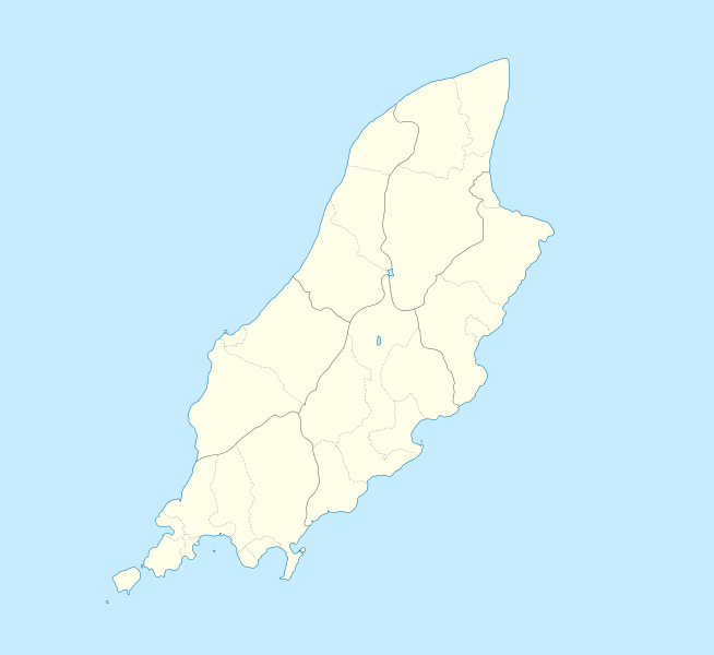
English: Location map of the Isle of Man, showing sheadings as well as local authorities (towns, villages, districts, parishes).
Geographic limits of the map:
|
| Date | |
| Source | |
| Author |
|
- You are free:
- to share – to copy, distribute and transmit the work
- to remix – to adapt the work
- Under the following conditions:
- attribution – You must give appropriate credit, provide a link to the license, and indicate if changes were made. You may do so in any reasonable manner, but not in any way that suggests the licensor endorses you or your use.
- share alike – If you remix, transform, or build upon the material, you must distribute your contributions under the same or compatible license as the original.
| This file is licensed under the Creative Commons Attribution-Share Alike 3.0 Unported license. | ||
| ||
| This licensing tag was added to this file as part of the GFDL licensing update. |

|
Permission is granted to copy, distribute and/or modify this document under the terms of the GNU Free Documentation License, Version 1.2 or any later version published by the Free Software Foundation; with no Invariant Sections, no Front-Cover Texts, and no Back-Cover Texts. A copy of the license is included in the section entitled GNU Free Documentation License. |
Original upload log
This image is a derivative work of the following images:
-
File:IsleOfMan_SheadingsAndParishes-en.svg licensed with Cc-by-sa-2.5,2.0,1.0, Cc-by-sa-3.0-migrated, GFDL
- 2008-01-17T12:48:28Z Sémhur 1200x1100 (227618 Bytes) Update
- 2007-05-29T20:36:04Z Sémhur 1200x1100 (364350 Bytes) {{Information |Description=Map in english of the [[:en:Isle of Man|Isle of Man]], with bounds of sheadings, towns, villages, districts and parishes. |Source=Own work. Based on maps [[:Image:Isle of Man map-fr.svg]], [[:Image:
Uploaded with derivativeFX
File history
Click on a date/time to view the file as it appeared at that time.
| Date/Time | Thumbnail | Dimensions | User | Comment | |
|---|---|---|---|---|---|
| current | 23:00, 24 September 2009 |
| 1,200 × 1,100 (93 KB) | Entlinkt | {{Information |Description={{en|1=Location map of the Isle of Man, showing sheadings as well as local authorities (towns, villages, districts, parishes). Geographic limits of the map: * W: -4° 58' 0" * E: -4° 7' 0" * S: 54° 0' 0" * N: 54° 27' 30"}} |
File usage
More than 100 pages use this file. The following list shows the first 100 pages that use this file only. A full list is available.
- 11th Milestone, Isle of Man
- 2017–18 Isle of Man Football League
- Andreas, Isle of Man
- Bahama Bank
- Ballabeg
- Ballabeg, Lonan
- Ballabeg station
- Ballacraine
- Ballacrye Corner
- Ballagarey Corner, Isle of Man
- Ballagarraghyn
- Ballakilpheric
- Ballasalla
- Ballaugh
- Ballaugh Bridge
- Ballure, Isle of Man
- Barregarrow
- Beinn-y-Phott
- Birkin's Bend
- Braaid
- Brandywell, Isle of Man
- Calf of Man
- Castletown, Isle of Man
- Chicken Rock
- Colby, Isle of Man
- Colby railway station
- Creg-ny-Baa, Isle of Man
- Cregneash
- Cronk Urleigh
- Crosby, Isle of Man
- Dalby, Isle of Man
- Derbyhaven
- Douglas, Isle of Man
- Dreswick Point
- Fairy Bridge (Isle of Man)
- Foxdale
- Ginger Hall
- Glen Duff
- Glen Helen, Isle of Man
- Glen Maye
- Glen Vine
- Gooseneck, Isle of Man
- Gorse Lea
- Greeba Bridge
- Groudle Glen
- Guthrie's Memorial, Isle of Man
- Hall Caine Airport
- Isle of Man Airport
- Isle of Man Football League
- Kate's Cottage, Isle of Man
- Keppel Gate, Isle of Man
- Langness Peninsula
- Laurel Bank
- Laxey
- Laxey Mine
- Manx Aviation and Military Museum
- Manx Museum
- Maughold Head
- Moddey Dhoo
- Mount Murray
- Newtown, Isle of Man
- Old House of Keys
- Old St Runius, Marown
- Onchan
- Orrisdale North
- Our Lady, Star of the Sea & St Maughold Church
- Peel, Isle of Man
- Peel Cathedral
- Point of Ayre
- Port Erin
- Port Soderick
- Port St Mary
- Quarry Bends
- RAF Andreas
- RAF Jurby
- RAF Jurby Head
- Ramsey, Isle of Man
- Ramsey Bay
- Rhencullen
- Ronague
- Sarah's Cottage, Isle of Man
- Snaefell
- Snaefell Mine
- St. Mary of the Isle Church
- St John's, Isle of Man
- St Patrick's Church, Jurby
- Strang, Isle of Man
- Sulby, Isle of Man
- Sulby Reservoir
- The Church of Jesus Christ of Latter-day Saints in the Isle of Man
- Tower Bends
- Tromode
- Union Mills
- Waterworks, Isle of Man
- West Baldwin Reservoir
- Whitestone Bank
- Talk:Isle of Man TT Mountain Course
- User:Beevil/sandbox
- User:DanCarolan/sandbox
- User:Michael!/Project:Location map templates/United Kingdom
View more links to this file.
Global file usage
The following other wikis use this file:
- Usage on af.wikipedia.org
- Usage on ar.wikipedia.org
- Usage on ast.wikipedia.org
- Usage on azb.wikipedia.org
- Usage on ba.wikipedia.org
- Usage on be.wikipedia.org
- Usage on bg.wikipedia.org
- Usage on bn.wikipedia.org
- Usage on br.wikipedia.org
- Usage on ceb.wikipedia.org
- Plantilya:Location map Isle of Man
- German
- Patrick
- Bride
- Andreas
- Douglas
- Saint Michaels Island
- Port Douglas
- Peel
- Isle of Man (pagklaro)
- Douglas Bay
- Isle of Man
- Santon
- Clay Head
- Craig Rock
- Ramsey Bay
- Rue Point
- Ramsey
- River Glass
- Chicken Rock
- Castletown
- Calf Sound
- Point of Ayre
- Crosby
- Little Ness
- Laksaa
- Snaefell
View more global usage of this file.
Original file (SVG file, nominally 1,200 × 1,100 pixels, file size: 93 KB)
| This is a file from the
Wikimedia Commons. Information from its
description page there is shown below. Commons is a freely licensed media file repository. You can help. |
| Description |
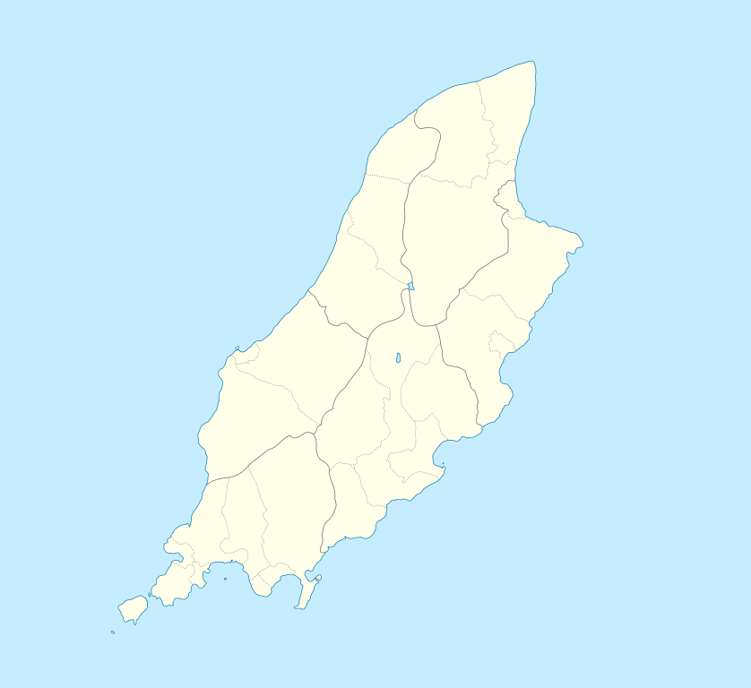
English: Location map of the Isle of Man, showing sheadings as well as local authorities (towns, villages, districts, parishes).
Geographic limits of the map:
|
| Date | |
| Source | |
| Author |
|
- You are free:
- to share – to copy, distribute and transmit the work
- to remix – to adapt the work
- Under the following conditions:
- attribution – You must give appropriate credit, provide a link to the license, and indicate if changes were made. You may do so in any reasonable manner, but not in any way that suggests the licensor endorses you or your use.
- share alike – If you remix, transform, or build upon the material, you must distribute your contributions under the same or compatible license as the original.
| This file is licensed under the Creative Commons Attribution-Share Alike 3.0 Unported license. | ||
| ||
| This licensing tag was added to this file as part of the GFDL licensing update. |
|
|
Permission is granted to copy, distribute and/or modify this document under the terms of the GNU Free Documentation License, Version 1.2 or any later version published by the Free Software Foundation; with no Invariant Sections, no Front-Cover Texts, and no Back-Cover Texts. A copy of the license is included in the section entitled GNU Free Documentation License. |
Original upload log
This image is a derivative work of the following images:
-
File:IsleOfMan_SheadingsAndParishes-en.svg licensed with Cc-by-sa-2.5,2.0,1.0, Cc-by-sa-3.0-migrated, GFDL
- 2008-01-17T12:48:28Z Sémhur 1200x1100 (227618 Bytes) Update
- 2007-05-29T20:36:04Z Sémhur 1200x1100 (364350 Bytes) {{Information |Description=Map in english of the [[:en:Isle of Man|Isle of Man]], with bounds of sheadings, towns, villages, districts and parishes. |Source=Own work. Based on maps [[:Image:Isle of Man map-fr.svg]], [[:Image:
Uploaded with derivativeFX
File history
Click on a date/time to view the file as it appeared at that time.
| Date/Time | Thumbnail | Dimensions | User | Comment | |
|---|---|---|---|---|---|
| current | 23:00, 24 September 2009 |
| 1,200 × 1,100 (93 KB) | Entlinkt | {{Information |Description={{en|1=Location map of the Isle of Man, showing sheadings as well as local authorities (towns, villages, districts, parishes). Geographic limits of the map: * W: -4° 58' 0" * E: -4° 7' 0" * S: 54° 0' 0" * N: 54° 27' 30"}} |
File usage
More than 100 pages use this file. The following list shows the first 100 pages that use this file only. A full list is available.
- 11th Milestone, Isle of Man
- 2017–18 Isle of Man Football League
- Andreas, Isle of Man
- Bahama Bank
- Ballabeg
- Ballabeg, Lonan
- Ballabeg station
- Ballacraine
- Ballacrye Corner
- Ballagarey Corner, Isle of Man
- Ballagarraghyn
- Ballakilpheric
- Ballasalla
- Ballaugh
- Ballaugh Bridge
- Ballure, Isle of Man
- Barregarrow
- Beinn-y-Phott
- Birkin's Bend
- Braaid
- Brandywell, Isle of Man
- Calf of Man
- Castletown, Isle of Man
- Chicken Rock
- Colby, Isle of Man
- Colby railway station
- Creg-ny-Baa, Isle of Man
- Cregneash
- Cronk Urleigh
- Crosby, Isle of Man
- Dalby, Isle of Man
- Derbyhaven
- Douglas, Isle of Man
- Dreswick Point
- Fairy Bridge (Isle of Man)
- Foxdale
- Ginger Hall
- Glen Duff
- Glen Helen, Isle of Man
- Glen Maye
- Glen Vine
- Gooseneck, Isle of Man
- Gorse Lea
- Greeba Bridge
- Groudle Glen
- Guthrie's Memorial, Isle of Man
- Hall Caine Airport
- Isle of Man Airport
- Isle of Man Football League
- Kate's Cottage, Isle of Man
- Keppel Gate, Isle of Man
- Langness Peninsula
- Laurel Bank
- Laxey
- Laxey Mine
- Manx Aviation and Military Museum
- Manx Museum
- Maughold Head
- Moddey Dhoo
- Mount Murray
- Newtown, Isle of Man
- Old House of Keys
- Old St Runius, Marown
- Onchan
- Orrisdale North
- Our Lady, Star of the Sea & St Maughold Church
- Peel, Isle of Man
- Peel Cathedral
- Point of Ayre
- Port Erin
- Port Soderick
- Port St Mary
- Quarry Bends
- RAF Andreas
- RAF Jurby
- RAF Jurby Head
- Ramsey, Isle of Man
- Ramsey Bay
- Rhencullen
- Ronague
- Sarah's Cottage, Isle of Man
- Snaefell
- Snaefell Mine
- St. Mary of the Isle Church
- St John's, Isle of Man
- St Patrick's Church, Jurby
- Strang, Isle of Man
- Sulby, Isle of Man
- Sulby Reservoir
- The Church of Jesus Christ of Latter-day Saints in the Isle of Man
- Tower Bends
- Tromode
- Union Mills
- Waterworks, Isle of Man
- West Baldwin Reservoir
- Whitestone Bank
- Talk:Isle of Man TT Mountain Course
- User:Beevil/sandbox
- User:DanCarolan/sandbox
- User:Michael!/Project:Location map templates/United Kingdom
View more links to this file.
Global file usage
The following other wikis use this file:
- Usage on af.wikipedia.org
- Usage on ar.wikipedia.org
- Usage on ast.wikipedia.org
- Usage on azb.wikipedia.org
- Usage on ba.wikipedia.org
- Usage on be.wikipedia.org
- Usage on bg.wikipedia.org
- Usage on bn.wikipedia.org
- Usage on br.wikipedia.org
- Usage on ceb.wikipedia.org
- Plantilya:Location map Isle of Man
- German
- Patrick
- Bride
- Andreas
- Douglas
- Saint Michaels Island
- Port Douglas
- Peel
- Isle of Man (pagklaro)
- Douglas Bay
- Isle of Man
- Santon
- Clay Head
- Craig Rock
- Ramsey Bay
- Rue Point
- Ramsey
- River Glass
- Chicken Rock
- Castletown
- Calf Sound
- Point of Ayre
- Crosby
- Little Ness
- Laksaa
- Snaefell
View more global usage of this file.