
Size of this PNG preview of this SVG file:
432 × 525 pixels. Other resolutions:
197 × 240 pixels |
395 × 480 pixels |
632 × 768 pixels |
843 × 1,024 pixels |
1,685 × 2,048 pixels.
Original file (SVG file, nominally 432 × 525 pixels, file size: 271 KB)
| This is a file from the
Wikimedia Commons. Information from its
description page there is shown below. Commons is a freely licensed media file repository. You can help. |
| Description |
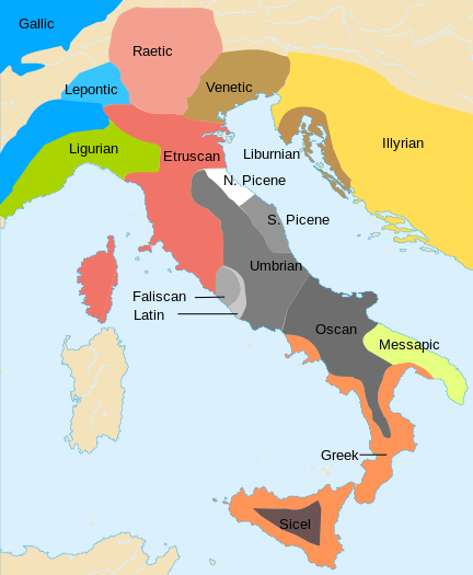
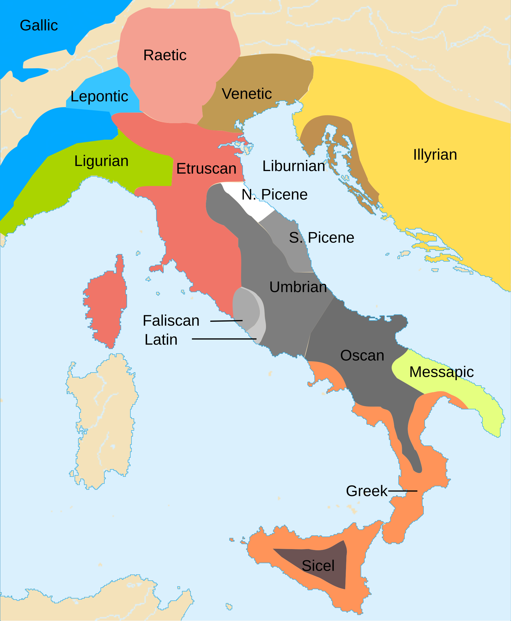
Afrikaans: Kaart van die tale wat in de Ysertydperk (omstreeks de 6e eeuw v.C.) in Italië gepraat is. Bahasa Indonesia: Bahasa-bahasa di Zaman Besi Italia, k. abad ke-6 SM. Deutsch: Sprachgebiete im Italien des 6. Jahrhunderts v. Chr. English: Languages in Iron Age Italy, ca. 6th c. BC. Español: Lenguas de la Italia de la Edad de Hierro, en torno al s. VI a.C. Italiano: Lingue diffuse in italia nell'età del ferro, sesto secolo a.C Latina: Linguae Aevo Ferri in Italia diffusae, ca. Saeculum 6 a.C.n. Nederlands: Kaart van de talen die in de IJzertijd (omstreeks de 6e eeuw v.Chr.) in Italië gesproken werden. Македонски:
Јазици во Италија во Железното време, ~VI век п.н.е. Русский: Языковая карта центральной м восточной частей
Средиземноморья в VI веке до н.э. 中文: 石器时代意大利半岛的各民族。 |
| Date | (UTC) |
| Source | |
| Author |
|
| Other versions |
|


| This is a
retouched picture, which means that it has been digitally altered from its original version. Modifications: Changed to SVG. The original can be viewed here:
Iron Age Italy.png:
|
I, the copyright holder of this work, hereby publish it under the following licenses:
| This file is licensed under the Creative Commons Attribution-Share Alike 3.0 Unported license. | ||
| ||
| This licensing tag was added to this file as part of the GFDL licensing update. |

|
Permission is granted to copy, distribute and/or modify this document under the terms of the GNU Free Documentation License, Version 1.2 or any later version published by the Free Software Foundation; with no Invariant Sections, no Front-Cover Texts, and no Back-Cover Texts. A copy of the license is included in the section entitled GNU Free Documentation License. |
You may select the license of your choice.
Original upload log
This image is a derivative work of the following images:
- File:Iron_Age_Italy.png licensed with Cc-by-sa-3.0-migrated, GFDL
Uploaded with derivativeFX
| Annotations | This image is annotated: View the annotations at Commons |
File history
Click on a date/time to view the file as it appeared at that time.
| Date/Time | Thumbnail | Dimensions | User | Comment | |
|---|---|---|---|---|---|
| current | 23:20, 1 December 2013 |
| 432 × 525 (271 KB) | Enok | Reverted to version as of 03:06, 10 September 2013 - No source on Sardinia |
| 17:18, 13 November 2013 |
 | 432 × 525 (241 KB) | Felisopus | Reverted to version as of 13:50, 22 May 2013; sources already provided. whole map have peculiar unsourced boundaries | |
| 03:06, 10 September 2013 |
 | 432 × 525 (271 KB) | Enok | Reverted to version as of 13:00, 22 December 2012 - no source on Sardinia | |
| 13:50, 22 May 2013 |
 | 432 × 525 (241 KB) | JBW | Disambiguating name | |
| 08:34, 6 January 2013 |
 | 432 × 525 (232 KB) | Felisopus | Reverted to version as of 11:20, 2 October 2012. no reason given, Category:Phoenicians in Sardinia | |
| 13:00, 22 December 2012 |
 | 432 × 525 (271 KB) | Enok | Reverted to version as of 14:58, 7 February 2011 | |
| 11:20, 2 October 2012 |
 | 432 × 525 (232 KB) | Felisopus | Reverted, rb. This map is called "Iron Age". this division of the island is present in all sources, http://it.wikipedia.org/wiki/File:LimesNuragiciPunici.JPG | |
| 01:42, 26 September 2012 |
 | 432 × 525 (271 KB) | Enok | Reverted to version as of 14:58, 7 February 2011 (Unsourced) | |
| 00:54, 24 September 2012 |
 | 432 × 525 (304 KB) | Daygum | Not punics in Sardinia in the Bronze Age, and the later punic presence was probably limited to the coasts, because there aren't sources to establish if punic was really widely spoken. | |
| 00:50, 24 September 2012 |
 | 432 × 525 (271 KB) | Daygum | Reverted to version as of 14:58, 7 February 2011 |
File usage
The following pages on the English Wikipedia use this file (pages on other projects are not listed):
- Adriatic Veneti
- History of Latin
- Insubres
- Italians
- Italic peoples
- Latins (Italic tribe)
- Liburnia
- Liburnian language
- Liburnians
- Ligures
- List of ancient Italic peoples
- List of ancient Ligurian tribes
- List of ancient peoples of Italy
- List of historical states of Italy
- Magna Graecia
- Messapic language
- Name of Italy
- North Picene language
- Osci
- Osco-Umbrian languages
- Picentes
- Picenum
- Roman expansion in Italy
- Siculian
- South Picene language
- Umbri
- Umbrian language
- Venetic language
- User:Falcaorib
- User:Milaqt/Gather lists/8832 – Language
- User talk:Chamberlain2007
Global file usage
The following other wikis use this file:
- Usage on an.wikipedia.org
- Usage on ar.wikipedia.org
- Usage on arz.wikipedia.org
- Usage on azb.wikipedia.org
- Usage on az.wikipedia.org
- Usage on be-tarask.wikipedia.org
- Usage on be.wikipedia.org
- Usage on br.wikipedia.org
- Usage on ca.wikipedia.org
- Usage on cs.wikipedia.org
- Usage on cy.wikipedia.org
- Usage on da.wikipedia.org
- Usage on de.wikipedia.org
- Usage on el.wikipedia.org
- Usage on en.wiktionary.org
- Usage on eo.wikipedia.org
- Usage on fa.wikipedia.org
- Usage on fi.wikipedia.org
- Usage on fr.wikipedia.org
- Usage on fr.wiktionary.org
- Usage on fy.wikipedia.org
- Usage on gv.wikipedia.org
- Usage on id.wikipedia.org
- Usage on ja.wikipedia.org
- Usage on ka.wikipedia.org
- Usage on ko.wikipedia.org
- Usage on lfn.wikipedia.org
- Usage on lv.wikipedia.org
View more global usage of this file.
Metadata
Size of this PNG preview of this SVG file:
432 × 525 pixels. Other resolutions:
197 × 240 pixels |
395 × 480 pixels |
632 × 768 pixels |
843 × 1,024 pixels |
1,685 × 2,048 pixels.
Original file (SVG file, nominally 432 × 525 pixels, file size: 271 KB)
| This is a file from the
Wikimedia Commons. Information from its
description page there is shown below. Commons is a freely licensed media file repository. You can help. |
| Description |
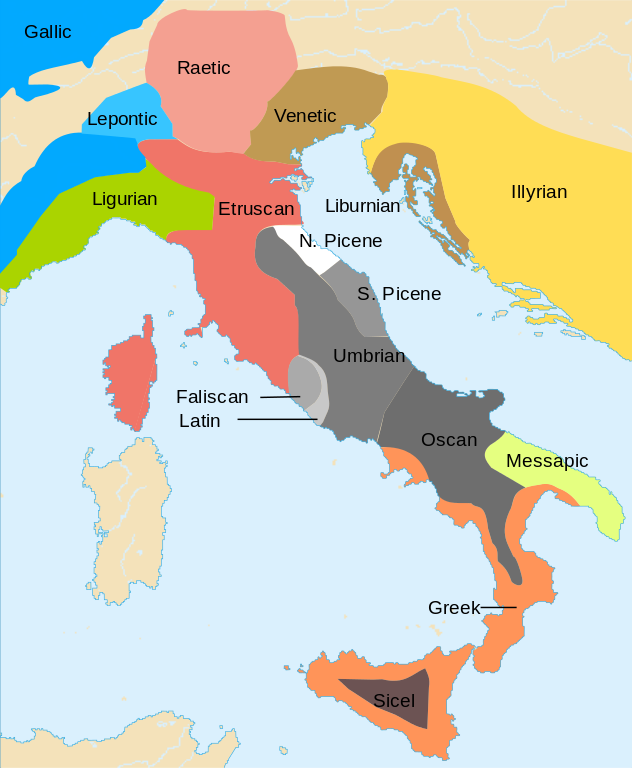
Afrikaans: Kaart van die tale wat in de Ysertydperk (omstreeks de 6e eeuw v.C.) in Italië gepraat is. Bahasa Indonesia: Bahasa-bahasa di Zaman Besi Italia, k. abad ke-6 SM. Deutsch: Sprachgebiete im Italien des 6. Jahrhunderts v. Chr. English: Languages in Iron Age Italy, ca. 6th c. BC. Español: Lenguas de la Italia de la Edad de Hierro, en torno al s. VI a.C. Italiano: Lingue diffuse in italia nell'età del ferro, sesto secolo a.C Latina: Linguae Aevo Ferri in Italia diffusae, ca. Saeculum 6 a.C.n. Nederlands: Kaart van de talen die in de IJzertijd (omstreeks de 6e eeuw v.Chr.) in Italië gesproken werden. Македонски:
Јазици во Италија во Железното време, ~VI век п.н.е. Русский: Языковая карта центральной м восточной частей
Средиземноморья в VI веке до н.э. 中文: 石器时代意大利半岛的各民族。 |
| Date | (UTC) |
| Source | |
| Author |
|
| Other versions |
|
| This is a
retouched picture, which means that it has been digitally altered from its original version. Modifications: Changed to SVG. The original can be viewed here:
Iron Age Italy.png:
|
I, the copyright holder of this work, hereby publish it under the following licenses:
| This file is licensed under the Creative Commons Attribution-Share Alike 3.0 Unported license. | ||
| ||
| This licensing tag was added to this file as part of the GFDL licensing update. |
|
|
Permission is granted to copy, distribute and/or modify this document under the terms of the GNU Free Documentation License, Version 1.2 or any later version published by the Free Software Foundation; with no Invariant Sections, no Front-Cover Texts, and no Back-Cover Texts. A copy of the license is included in the section entitled GNU Free Documentation License. |
You may select the license of your choice.
Original upload log
This image is a derivative work of the following images:
- File:Iron_Age_Italy.png licensed with Cc-by-sa-3.0-migrated, GFDL
Uploaded with derivativeFX
| Annotations | This image is annotated: View the annotations at Commons |
File history
Click on a date/time to view the file as it appeared at that time.
| Date/Time | Thumbnail | Dimensions | User | Comment | |
|---|---|---|---|---|---|
| current | 23:20, 1 December 2013 |
| 432 × 525 (271 KB) | Enok | Reverted to version as of 03:06, 10 September 2013 - No source on Sardinia |
| 17:18, 13 November 2013 |
| 432 × 525 (241 KB) | Felisopus | Reverted to version as of 13:50, 22 May 2013; sources already provided. whole map have peculiar unsourced boundaries | |
| 03:06, 10 September 2013 |
| 432 × 525 (271 KB) | Enok | Reverted to version as of 13:00, 22 December 2012 - no source on Sardinia | |
| 13:50, 22 May 2013 |
| 432 × 525 (241 KB) | JBW | Disambiguating name | |
| 08:34, 6 January 2013 |
| 432 × 525 (232 KB) | Felisopus | Reverted to version as of 11:20, 2 October 2012. no reason given, Category:Phoenicians in Sardinia | |
| 13:00, 22 December 2012 |
| 432 × 525 (271 KB) | Enok | Reverted to version as of 14:58, 7 February 2011 | |
| 11:20, 2 October 2012 |
| 432 × 525 (232 KB) | Felisopus | Reverted, rb. This map is called "Iron Age". this division of the island is present in all sources, http://it.wikipedia.org/wiki/File:LimesNuragiciPunici.JPG | |
| 01:42, 26 September 2012 |
| 432 × 525 (271 KB) | Enok | Reverted to version as of 14:58, 7 February 2011 (Unsourced) | |
| 00:54, 24 September 2012 |
| 432 × 525 (304 KB) | Daygum | Not punics in Sardinia in the Bronze Age, and the later punic presence was probably limited to the coasts, because there aren't sources to establish if punic was really widely spoken. | |
| 00:50, 24 September 2012 |
| 432 × 525 (271 KB) | Daygum | Reverted to version as of 14:58, 7 February 2011 |
File usage
The following pages on the English Wikipedia use this file (pages on other projects are not listed):
- Adriatic Veneti
- History of Latin
- Insubres
- Italians
- Italic peoples
- Latins (Italic tribe)
- Liburnia
- Liburnian language
- Liburnians
- Ligures
- List of ancient Italic peoples
- List of ancient Ligurian tribes
- List of ancient peoples of Italy
- List of historical states of Italy
- Magna Graecia
- Messapic language
- Name of Italy
- North Picene language
- Osci
- Osco-Umbrian languages
- Picentes
- Picenum
- Roman expansion in Italy
- Siculian
- South Picene language
- Umbri
- Umbrian language
- Venetic language
- User:Falcaorib
- User:Milaqt/Gather lists/8832 – Language
- User talk:Chamberlain2007
Global file usage
The following other wikis use this file:
- Usage on an.wikipedia.org
- Usage on ar.wikipedia.org
- Usage on arz.wikipedia.org
- Usage on azb.wikipedia.org
- Usage on az.wikipedia.org
- Usage on be-tarask.wikipedia.org
- Usage on be.wikipedia.org
- Usage on br.wikipedia.org
- Usage on ca.wikipedia.org
- Usage on cs.wikipedia.org
- Usage on cy.wikipedia.org
- Usage on da.wikipedia.org
- Usage on de.wikipedia.org
- Usage on el.wikipedia.org
- Usage on en.wiktionary.org
- Usage on eo.wikipedia.org
- Usage on fa.wikipedia.org
- Usage on fi.wikipedia.org
- Usage on fr.wikipedia.org
- Usage on fr.wiktionary.org
- Usage on fy.wikipedia.org
- Usage on gv.wikipedia.org
- Usage on id.wikipedia.org
- Usage on ja.wikipedia.org
- Usage on ka.wikipedia.org
- Usage on ko.wikipedia.org
- Usage on lfn.wikipedia.org
- Usage on lv.wikipedia.org
View more global usage of this file.