Original file (1,318 × 1,027 pixels, file size: 341 KB, MIME type: image/jpeg)
| Description |
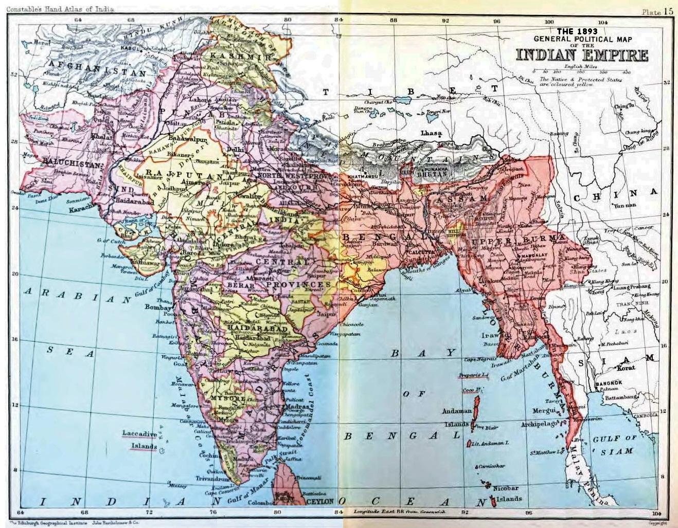
Map, "Political Map of the Indian Empire, 1893" from Constable's Hand Atlas of India, London: Archibald Constable and Sons, 1893. Uploaded by Fowler&fowler «Talk» 23:20, 13 February 2009 (UTC) |
|---|---|
| Source | |
| Date |
1893 |
| Author |
John Bartholomew and Co., Edinburgh |
| Permission ( Reusing this file) |
See below.
|
Please do not transfer to Wikimedia Commons without my permission (for example, if I am on Wikibreak, then please wait for my return) and without making sure that you have the correct uploading information. Fowler&fowler «Talk» 18:56, 8 June 2009 (UTC)
| This image is in the public domain in the United States because it was first published outside the United States prior to January 1, 1929. Other jurisdictions have other rules. Also note that this image may not be in the public domain in the 9th Circuit if it was first published on or after July 1, 1909 in noncompliance with US formalities, unless the author is known to have died in 1953 or earlier (more than 70 years ago) or the work was created in 1903 or earlier (more than 120 years ago.) [1] |
|
 | Do not copy this file to Wikimedia Commons. This file might not be in the public domain outside the United States and should not be transferred to Wikimedia Commons unless it can be verified to be in the public domain in its country of first publication and that at least 70 years have elapsed since the author died. Commons requires that images be free in the source country and in the United States. If this file is in the public domain outside the United States, add |pdsource=yes to this template to hide this warning.If this file is not in the public domain in the source country but will become so in the future, add |out_of_copyright_in= and then the year its copyright will expire. |
| The uploader or another editor requests that a local copy of this file be kept. This image or media file is available on the Wikimedia Commons as Image:IndiaPolitical1893ConstablesHandAtlas.jpg. While the license of this file may be compliant with the Wikimedia Commons, an editor has requested that the local copy be kept too. This file does not meet CSD F8 and should not be tagged as a Commons duplicate. If you desire to nominate it for deletion, notify the tagging editor. |
|
File history
Click on a date/time to view the file as it appeared at that time.
| Date/Time | Thumbnail | Dimensions | User | Comment | |
|---|---|---|---|---|---|
| current | 14:48, 23 March 2022 |
| 1,318 × 1,027 (341 KB) | Scratchinghead ( talk | contribs) | Reverted to version as of 23:20, 13 February 2009 (UTC) again the singrauli forgery. When will you stop? |
| 19:41, 21 March 2022 |
 | 1,318 × 1,027 (433 KB) | HistoricGeek2345 ( talk | contribs) | Corrected borders, area. | |
| 23:20, 13 February 2009 |
 | 1,318 × 1,027 (341 KB) | Fowler&fowler ( talk | contribs) | {{Information |Description=Map, "Political Map of the Indian Empire, 1893" from Constable's Hand Atlas of India, London: Archibald Constable and Sons, 1893. Uploaded by ~~~~ |Source=http://books.google.com/books?id=-kAuAAAAYAAJ |Date=1893 |Author=John Ba |
You cannot overwrite this file.
File usage
The following file is a duplicate of this file ( more details):
- File:IndiaPolitical1893ConstablesHandAtlas.jpg from Commons
- Agencies of British India
- Bombay Presidency
- British Raj
- British rule in Burma
- British rule in Portuguese India
- Casa da Índia
- Colonial India
- Company rule in India
- Danish India
- Districts of British India
- Divisions of British India
- Dutch India
- East India Company
- French East India Company
- French India
- History of the British Raj
- India Office Records
- Indian Rebellion of 1857
- Indian independence movement
- Madras Presidency
- New Imperialism
- Non-cooperation movement (1919–1922)
- Portuguese East India Company
- Portuguese India
- Presidencies and provinces of British India
- Princely state
- Slavery in Madras Presidency
- Subdivisions of British India
- Talk:British rule in Burma
- Talk:East India Company/Archive 2
- Talk:Partition of India/Archive 2
- Talk:Presidencies and provinces of British India/Archive 3
- Talk:Presidencies and provinces of British India/Archive 4
- User:Falcaorib
- User:Fowler&fowler
- User:Fowler&fowler/British Empire in India
- User:Fowler&fowler/British India-2
- Template:Colonial India
Metadata
Original file (1,318 × 1,027 pixels, file size: 341 KB, MIME type: image/jpeg)
| Description |
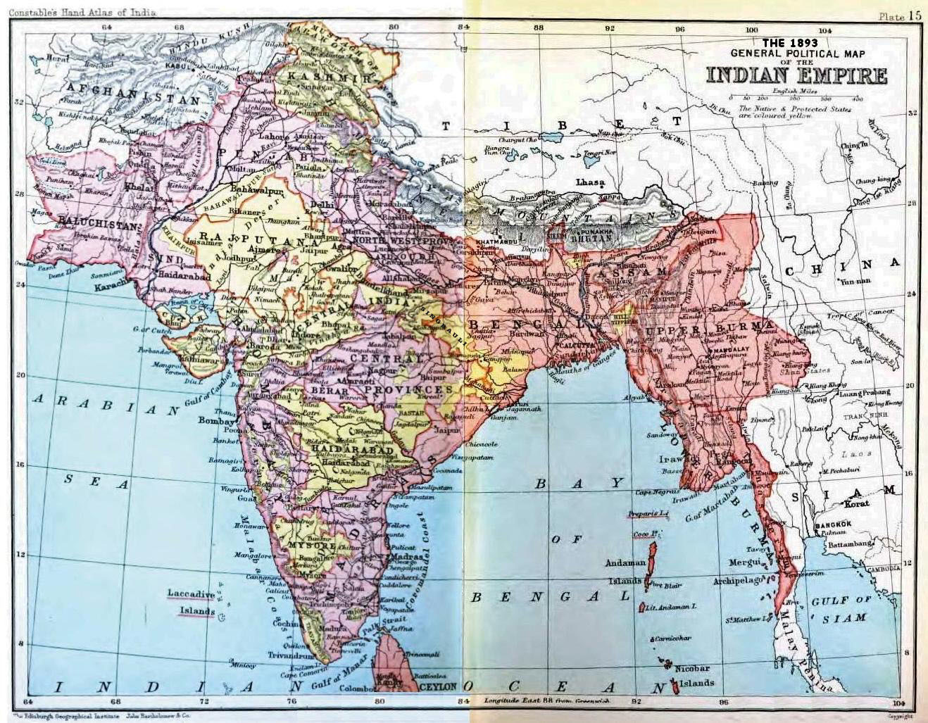
Map, "Political Map of the Indian Empire, 1893" from Constable's Hand Atlas of India, London: Archibald Constable and Sons, 1893. Uploaded by Fowler&fowler «Talk» 23:20, 13 February 2009 (UTC) |
|---|---|
| Source | |
| Date |
1893 |
| Author |
John Bartholomew and Co., Edinburgh |
| Permission ( Reusing this file) |
See below.
|
Please do not transfer to Wikimedia Commons without my permission (for example, if I am on Wikibreak, then please wait for my return) and without making sure that you have the correct uploading information. Fowler&fowler «Talk» 18:56, 8 June 2009 (UTC)
| This image is in the public domain in the United States because it was first published outside the United States prior to January 1, 1929. Other jurisdictions have other rules. Also note that this image may not be in the public domain in the 9th Circuit if it was first published on or after July 1, 1909 in noncompliance with US formalities, unless the author is known to have died in 1953 or earlier (more than 70 years ago) or the work was created in 1903 or earlier (more than 120 years ago.) [1] |
|
|
| Do not copy this file to Wikimedia Commons. This file might not be in the public domain outside the United States and should not be transferred to Wikimedia Commons unless it can be verified to be in the public domain in its country of first publication and that at least 70 years have elapsed since the author died. Commons requires that images be free in the source country and in the United States. If this file is in the public domain outside the United States, add |pdsource=yes to this template to hide this warning.If this file is not in the public domain in the source country but will become so in the future, add |out_of_copyright_in= and then the year its copyright will expire. |
| The uploader or another editor requests that a local copy of this file be kept. This image or media file is available on the Wikimedia Commons as Image:IndiaPolitical1893ConstablesHandAtlas.jpg. While the license of this file may be compliant with the Wikimedia Commons, an editor has requested that the local copy be kept too. This file does not meet CSD F8 and should not be tagged as a Commons duplicate. If you desire to nominate it for deletion, notify the tagging editor. |
|
File history
Click on a date/time to view the file as it appeared at that time.
| Date/Time | Thumbnail | Dimensions | User | Comment | |
|---|---|---|---|---|---|
| current | 14:48, 23 March 2022 |
| 1,318 × 1,027 (341 KB) | Scratchinghead ( talk | contribs) | Reverted to version as of 23:20, 13 February 2009 (UTC) again the singrauli forgery. When will you stop? |
| 19:41, 21 March 2022 |
| 1,318 × 1,027 (433 KB) | HistoricGeek2345 ( talk | contribs) | Corrected borders, area. | |
| 23:20, 13 February 2009 |
| 1,318 × 1,027 (341 KB) | Fowler&fowler ( talk | contribs) | {{Information |Description=Map, "Political Map of the Indian Empire, 1893" from Constable's Hand Atlas of India, London: Archibald Constable and Sons, 1893. Uploaded by ~~~~ |Source=http://books.google.com/books?id=-kAuAAAAYAAJ |Date=1893 |Author=John Ba |
You cannot overwrite this file.
File usage
The following file is a duplicate of this file ( more details):
- File:IndiaPolitical1893ConstablesHandAtlas.jpg from Commons
- Agencies of British India
- Bombay Presidency
- British Raj
- British rule in Burma
- British rule in Portuguese India
- Casa da Índia
- Colonial India
- Company rule in India
- Danish India
- Districts of British India
- Divisions of British India
- Dutch India
- East India Company
- French East India Company
- French India
- History of the British Raj
- India Office Records
- Indian Rebellion of 1857
- Indian independence movement
- Madras Presidency
- New Imperialism
- Non-cooperation movement (1919–1922)
- Portuguese East India Company
- Portuguese India
- Presidencies and provinces of British India
- Princely state
- Slavery in Madras Presidency
- Subdivisions of British India
- Talk:British rule in Burma
- Talk:East India Company/Archive 2
- Talk:Partition of India/Archive 2
- Talk:Presidencies and provinces of British India/Archive 3
- Talk:Presidencies and provinces of British India/Archive 4
- User:Falcaorib
- User:Fowler&fowler
- User:Fowler&fowler/British Empire in India
- User:Fowler&fowler/British India-2
- Template:Colonial India