Independence_Rock_WY.jpg (489 × 305 pixels, file size: 67 KB, MIME type: image/jpeg)
| This is a file from the
Wikimedia Commons. Information from its
description page there is shown below. Commons is a freely licensed media file repository. You can help. |
|
This is an image of a place or building that is listed on the
National Register of Historic Places in the
United States of America. Its reference number is
66000757. |
Summary
Source: Wikipedia EN (there uploaded by Matthew Trump)
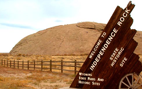
Independence Rock in Natrona County, Wyoming (taken Oct. 17, 2004 by Matthew Trump)
Licensing
| This file is licensed under the Creative Commons Attribution-Share Alike 3.0 Unported license. Subject to disclaimers. | ||
| ||
| This licensing tag was added to this file as part of the GFDL licensing update. |

|
Permission is granted to copy, distribute and/or modify this document under the terms of the GNU Free Documentation License, Version 1.2 or any later version published by the Free Software Foundation; with no Invariant Sections, no Front-Cover Texts, and no Back-Cover Texts. A copy of the license is included in the section entitled GNU Free Documentation License. Subject to disclaimers. |
| Object location |
| View this and other nearby images on: OpenStreetMap |
|
|---|
File history
Click on a date/time to view the file as it appeared at that time.
| Date/Time | Thumbnail | Dimensions | User | Comment | |
|---|---|---|---|---|---|
| current | 16:44, 29 May 2006 |
| 489 × 305 (67 KB) | Sascha Brück~commonswiki | '''Source:''' Wikipedia EN (there uploaded by Matthew Trump) ---- Independence Rock (Wyoming) in Natrona County, Wyoming (taken Oct. 17, 2004 by Matthew Trump) Category:State Parks of Wyoming |
File usage
Global file usage
The following other wikis use this file:
- Usage on de.wikipedia.org
- Usage on fi.wikipedia.org
- Usage on fr.wikipedia.org
- Usage on incubator.wikimedia.org
- Usage on it.wikipedia.org
- Usage on nl.wikipedia.org
- Usage on pt.wikipedia.org
- Usage on ur.wikipedia.org
Metadata
Independence_Rock_WY.jpg (489 × 305 pixels, file size: 67 KB, MIME type: image/jpeg)
| This is a file from the
Wikimedia Commons. Information from its
description page there is shown below. Commons is a freely licensed media file repository. You can help. |
|
This is an image of a place or building that is listed on the
National Register of Historic Places in the
United States of America. Its reference number is
66000757. |
Summary
Source: Wikipedia EN (there uploaded by Matthew Trump)
Independence Rock in Natrona County, Wyoming (taken Oct. 17, 2004 by Matthew Trump)
Licensing
| This file is licensed under the Creative Commons Attribution-Share Alike 3.0 Unported license. Subject to disclaimers. | ||
| ||
| This licensing tag was added to this file as part of the GFDL licensing update. |
|
|
Permission is granted to copy, distribute and/or modify this document under the terms of the GNU Free Documentation License, Version 1.2 or any later version published by the Free Software Foundation; with no Invariant Sections, no Front-Cover Texts, and no Back-Cover Texts. A copy of the license is included in the section entitled GNU Free Documentation License. Subject to disclaimers. |
| Object location |
| View this and other nearby images on: OpenStreetMap |
|
|---|
File history
Click on a date/time to view the file as it appeared at that time.
| Date/Time | Thumbnail | Dimensions | User | Comment | |
|---|---|---|---|---|---|
| current | 16:44, 29 May 2006 |
| 489 × 305 (67 KB) | Sascha Brück~commonswiki | '''Source:''' Wikipedia EN (there uploaded by Matthew Trump) ---- Independence Rock (Wyoming) in Natrona County, Wyoming (taken Oct. 17, 2004 by Matthew Trump) Category:State Parks of Wyoming |
File usage
Global file usage
The following other wikis use this file:
- Usage on de.wikipedia.org
- Usage on fi.wikipedia.org
- Usage on fr.wikipedia.org
- Usage on incubator.wikimedia.org
- Usage on it.wikipedia.org
- Usage on nl.wikipedia.org
- Usage on pt.wikipedia.org
- Usage on ur.wikipedia.org