Size of this preview:
800 × 450 pixels. Other resolutions:
320 × 180 pixels |
640 × 360 pixels |
1,024 × 576 pixels |
1,280 × 720 pixels |
1,920 × 1,080 pixels.
Original file (1,920 × 1,080 pixels, file size: 1.96 MB, MIME type: image/png)
| This is a file from the
Wikimedia Commons. Information from its
description page there is shown below. Commons is a freely licensed media file repository. You can help. |
Summary
| Description |
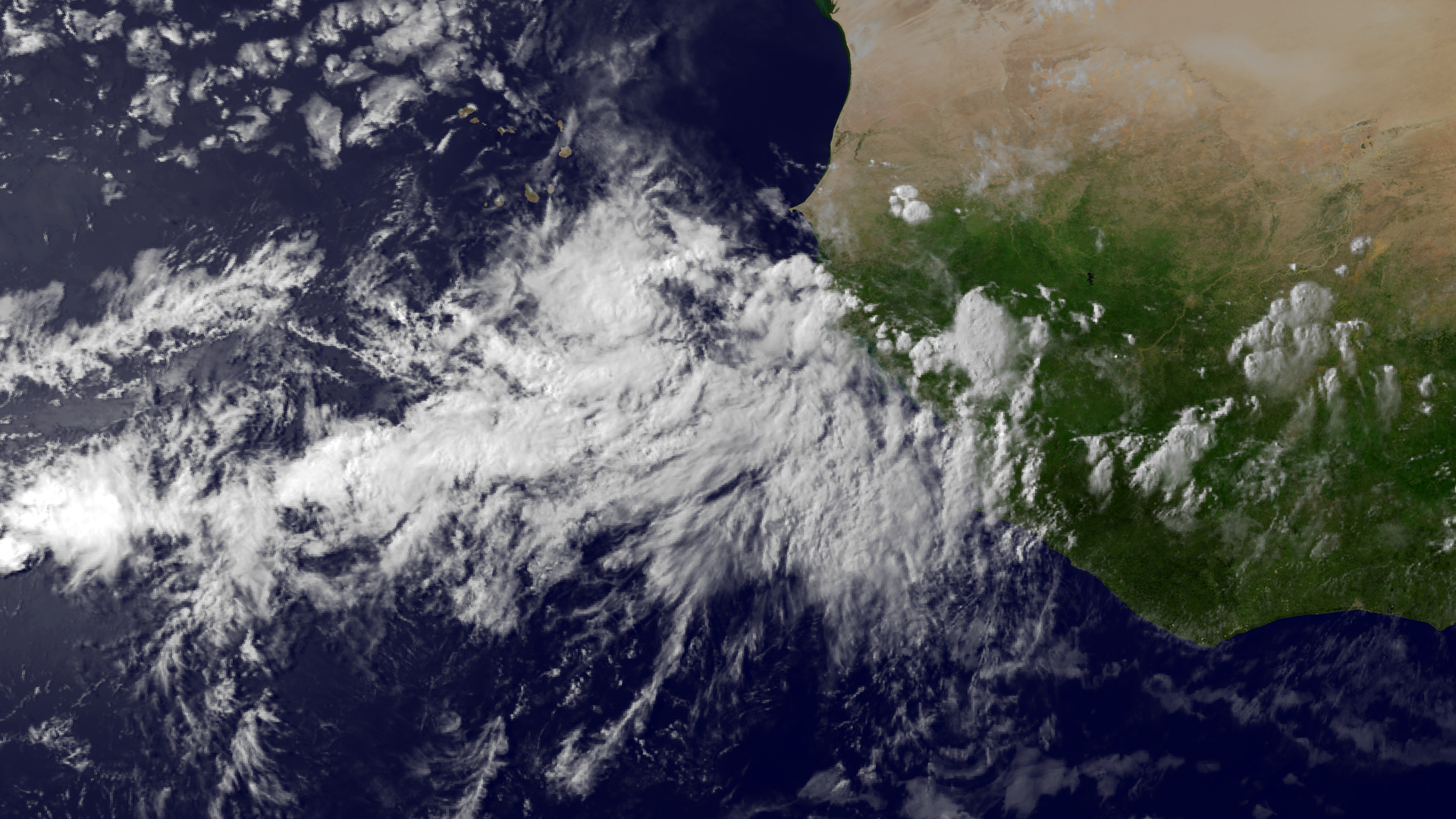
English: A tropical wave accompanied by a surface low pressure system is located east-southeast of the Cape Verde Islands. Thunderstorm activity has increased and become better organized today, and environmental conditions are expected to be favorable for development over the next day or so, before becoming less conducive later in the week. This image was taken by Meteosat-10 at 1715Z on July 22, 2013. |
| Date | |
| Source | http://www.nnvl.noaa.gov/MediaDetail2.php?MediaID=1391&MediaTypeID=1 |
| Author | The National Oceanic and Atmospheric Administration |
Licensing
This image is in the
public domain because it contains materials that originally came from the U.S.
National Oceanic and Atmospheric Administration, taken or made as part of an employee's official duties.
|
File history
Click on a date/time to view the file as it appeared at that time.
| Date/Time | Thumbnail | Dimensions | User | Comment | |
|---|---|---|---|---|---|
| current | 17:18, 24 July 2013 |
| 1,920 × 1,080 (1.96 MB) | Supportstorm | {{Information |Description ={{en|1=A tropical wave accompanied by a surface low pressure system is located east-southeast of the Cape Verde Islands. Thunderstorm activity has increased and become better organized today, and environmental conditions ... |
File usage
The following pages on the English Wikipedia use this file (pages on other projects are not listed):
Metadata
Size of this preview:
800 × 450 pixels. Other resolutions:
320 × 180 pixels |
640 × 360 pixels |
1,024 × 576 pixels |
1,280 × 720 pixels |
1,920 × 1,080 pixels.
Original file (1,920 × 1,080 pixels, file size: 1.96 MB, MIME type: image/png)
| This is a file from the
Wikimedia Commons. Information from its
description page there is shown below. Commons is a freely licensed media file repository. You can help. |
Summary
| Description |
English: A tropical wave accompanied by a surface low pressure system is located east-southeast of the Cape Verde Islands. Thunderstorm activity has increased and become better organized today, and environmental conditions are expected to be favorable for development over the next day or so, before becoming less conducive later in the week. This image was taken by Meteosat-10 at 1715Z on July 22, 2013. |
| Date | |
| Source | http://www.nnvl.noaa.gov/MediaDetail2.php?MediaID=1391&MediaTypeID=1 |
| Author | The National Oceanic and Atmospheric Administration |
Licensing
This image is in the
public domain because it contains materials that originally came from the U.S.
National Oceanic and Atmospheric Administration, taken or made as part of an employee's official duties.
|
File history
Click on a date/time to view the file as it appeared at that time.
| Date/Time | Thumbnail | Dimensions | User | Comment | |
|---|---|---|---|---|---|
| current | 17:18, 24 July 2013 |
| 1,920 × 1,080 (1.96 MB) | Supportstorm | {{Information |Description ={{en|1=A tropical wave accompanied by a surface low pressure system is located east-southeast of the Cape Verde Islands. Thunderstorm activity has increased and become better organized today, and environmental conditions ... |
File usage
The following pages on the English Wikipedia use this file (pages on other projects are not listed):