Photos • Location


Size of this preview:
800 × 600 pixels. Other resolutions:
320 × 240 pixels |
640 × 480 pixels |
1,024 × 768 pixels |
1,280 × 960 pixels |
2,272 × 1,704 pixels.
Original file (2,272 × 1,704 pixels, file size: 1.85 MB, MIME type: image/jpeg)
| This is a file from the
Wikimedia Commons. Information from its
description page there is shown below. Commons is a freely licensed media file repository. You can help. |
| Camera location |
| View this and other nearby images on: OpenStreetMap |
|
|---|
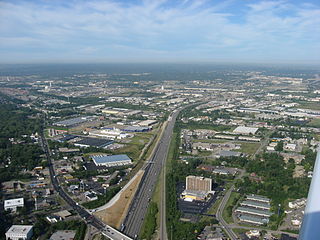
| Description | Aerial view of Interstate 275 in the city of Sharonville just west of its interchange with U.S. Route 42, northeast of the city of Cincinnati, Ohio, United States. Picture taken from a Diamond Eclipse light airplane at an altitude of 1,750 feet MSL and a bearing of approximately 248º. | ||
| Date | Taken on 12 August 2008 | ||
| Source | Own work | ||
| Author | Nyttend | ||
| Permission ( Reusing this file) |
|
File history
Click on a date/time to view the file as it appeared at that time.
| Date/Time | Thumbnail | Dimensions | User | Comment | |
|---|---|---|---|---|---|
| current | 02:47, 23 September 2008 |
| 2,272 × 1,704 (1.85 MB) | Nyttend | {{Information |Description=Aerial view of {{w|Interstate 275 (Ohio)|Interstate 275}} in the city of {{w|Sharonville, Ohio|Sharonville}} just west of its interchange with {{w|U.S. Route 42}}, northeast of the city of {{w|Cincinnati, Ohio|Cincinnati}}, {{w| |
File usage
The following pages on the English Wikipedia use this file (pages on other projects are not listed):
Global file usage
The following other wikis use this file:
- Usage on uk.wikipedia.org
Metadata
Size of this preview:
800 × 600 pixels. Other resolutions:
320 × 240 pixels |
640 × 480 pixels |
1,024 × 768 pixels |
1,280 × 960 pixels |
2,272 × 1,704 pixels.
Original file (2,272 × 1,704 pixels, file size: 1.85 MB, MIME type: image/jpeg)
| This is a file from the
Wikimedia Commons. Information from its
description page there is shown below. Commons is a freely licensed media file repository. You can help. |
| Camera location |
| View this and other nearby images on: OpenStreetMap |
|
|---|
| Description | Aerial view of Interstate 275 in the city of Sharonville just west of its interchange with U.S. Route 42, northeast of the city of Cincinnati, Ohio, United States. Picture taken from a Diamond Eclipse light airplane at an altitude of 1,750 feet MSL and a bearing of approximately 248º. | ||
| Date | Taken on 12 August 2008 | ||
| Source | Own work | ||
| Author | Nyttend | ||
| Permission ( Reusing this file) |
|
File history
Click on a date/time to view the file as it appeared at that time.
| Date/Time | Thumbnail | Dimensions | User | Comment | |
|---|---|---|---|---|---|
| current | 02:47, 23 September 2008 |
| 2,272 × 1,704 (1.85 MB) | Nyttend | {{Information |Description=Aerial view of {{w|Interstate 275 (Ohio)|Interstate 275}} in the city of {{w|Sharonville, Ohio|Sharonville}} just west of its interchange with {{w|U.S. Route 42}}, northeast of the city of {{w|Cincinnati, Ohio|Cincinnati}}, {{w| |
File usage
The following pages on the English Wikipedia use this file (pages on other projects are not listed):
Global file usage
The following other wikis use this file:
- Usage on uk.wikipedia.org