
Original file (SVG file, nominally 1,320 × 1,424 pixels, file size: 5.26 MB)
| This is a file from the
Wikimedia Commons. Information from its
description page there is shown below. Commons is a freely licensed media file repository. You can help. |
| Description |
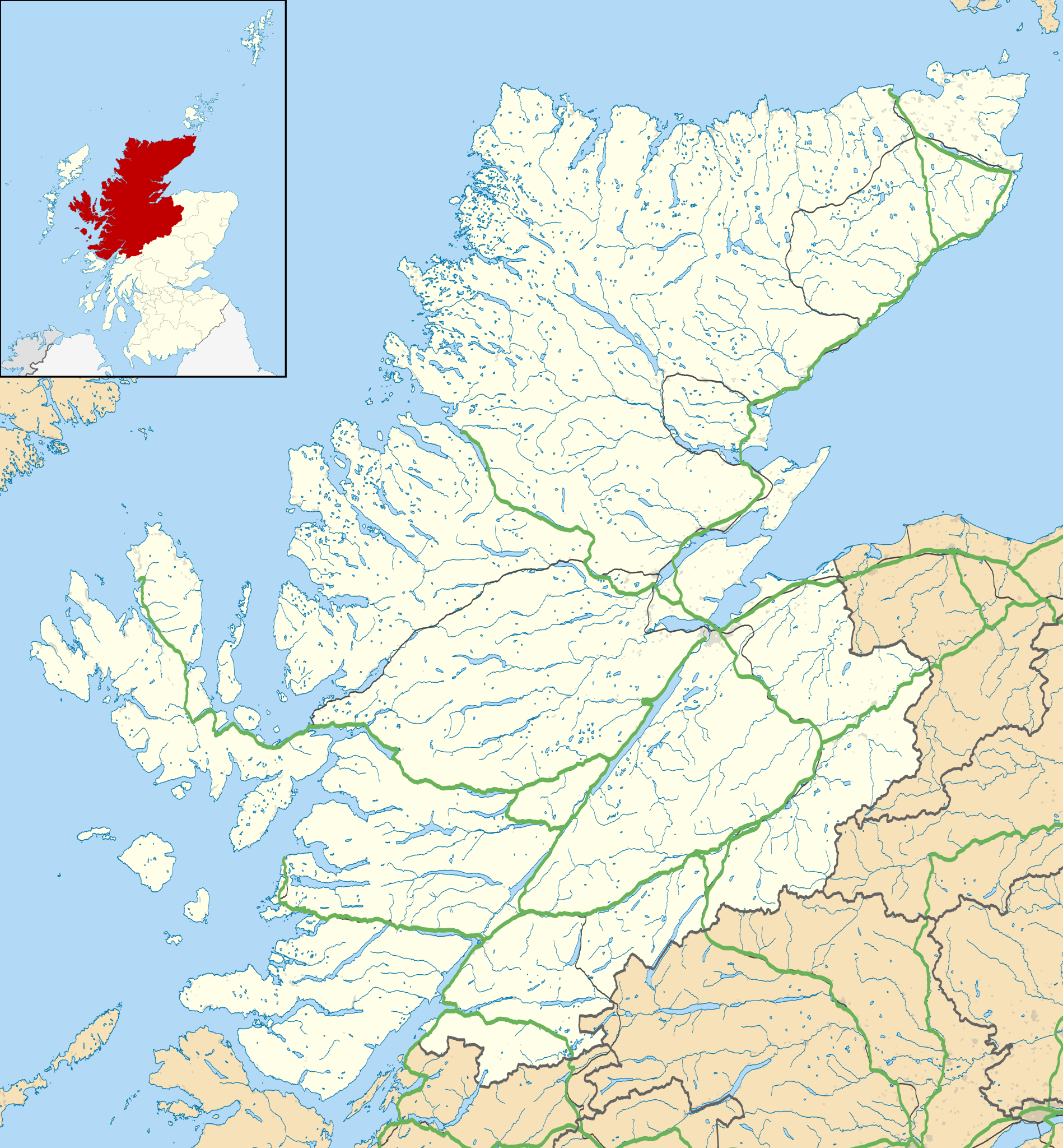
Blank map of Highland, UK with the following information shown:
Equirectangular map projection on WGS 84 datum, with N/S stretched 180% Geographic limits:
|
| Date | |
| Source |
|
| Author | Nilfanion, created using Ordnance Survey data |
| Permission ( Reusing this file) |
This file is licensed under the
Creative Commons
Attribution-Share Alike 3.0 Unported license. Attribution: Contains Ordnance Survey data © Crown copyright and database right
|
| Other versions | File:Highland UK blank map.svg - Blank map |
File history
Click on a date/time to view the file as it appeared at that time.
| Date/Time | Thumbnail | Dimensions | User | Comment | |
|---|---|---|---|---|---|
| current | 20:20, 26 September 2010 |
| 1,320 × 1,424 (5.26 MB) | Nilfanion | {{Information |Description=Blank map of Highland, UK with the following information shown: *Administrative borders *Coastline, lakes and rivers *Roads and railways *Urban areas Equirectangular map projection on WGS 84 datum, |
File usage
More than 100 pages use this file. The following list shows the first 100 pages that use this file only. A full list is available.
- 1999–2000 Scottish First Division
- A' Chill
- Achgarve
- Achmore, Highland
- Achnagarron
- Achnasheen
- Achnashellach
- Achterneed
- Achtoty
- Airor
- Allt-na-h-Airbhe
- Altandhu
- Altrua
- Amatnatua
- An Ard
- Anancaun
- Ankerville
- Annat, Highland
- Ardaneaskan
- Ardelve
- Ardersier
- Ardessie
- Ardheslaig
- Ardmair
- Ardmore, Easter Ross
- Ardullie
- Ardvreck Castle
- Aultbea
- Aultgrishan
- Avernish
- Avoch
- BUTEC
- Badachro
- Badluarach
- Badrallach
- Balintore, Easter Ross
- Balintraid
- Ballifeary
- Balmacara Square
- Balnacra
- Balnagown Castle
- Balnapaling
- Barbaraville
- Beauly
- Big Sand
- Bishop Kinkell
- Brae of Achnahaird
- Carbisdale Castle
- Carn Liath (broch)
- Cawdor Castle
- Creich, Sutherland
- Dalneigh
- Dun Dornaigil
- Glen Shiel
- Grantown-on-Spey
- Highland (council area)
- Insh
- Insh Marshes
- Inverness
- Inverness Airport
- Inverness Cathedral
- Kinloch Castle
- Kinmylies
- Knockan Crag
- Knoydart
- List of monastic houses in Scotland
- Mounteagle transmitting station
- Murlagan
- Nairn
- Newton of Ferintosh
- Newton of Kinkell
- North Caledonian Football Association
- Opinan, Gairloch
- Ormiscaig
- Ormond Castle
- Pitcalnie
- Plockton
- Port Henderson
- Portgower
- Raddery
- Redpoint
- Rhue, Scotland
- Rockfield, Highland
- Rumster Forest transmitting station
- Shandwick
- Skelbo Castle
- Spean Bridge
- Strathrusdale
- Strathy, Ardross
- Stromeferry
- Strontian
- Summer Isles
- Tain
- Tain Air Weapons Range
- Tore, Scotland
- Torridon
- Toulvaddie
- Trotternish
- Wick, Caithness
- Wick Airport
View more links to this file.
Global file usage
The following other wikis use this file:
- Usage on ar.wikipedia.org
- Usage on arz.wikipedia.org
- Usage on ba.wikipedia.org
- Usage on bg.wikipedia.org
- Usage on ceb.wikipedia.org
- Usage on de.wikipedia.org
- Kernkraftwerk Dounreay
- Skye Bridge
- Caledonian Stadium
- Neist Point
- Victoria Park (Dingwall)
- Loch Eriboll
- Tarbat Ness Lighthouse
- Ardnamurchan Lighthouse
- Sandwood Bay
- Vorlage:Positionskarte Schottland Highland
- Flughafen Inverness
- Culloden Viaduct
- Fearn Airfield
- Bone Caves
- Wick Airport
- Flugplatz Broadford
- Flugplatz Plockton
- Affric-Beauly-Kraftwerke
- Cromarty Lighthouse
- Leuchtturm Dunnet Head
- Telford Street Park
- Chanonry Lighthouse
- Noss Head Lighthouse
- Cape Wrath Lighthouse
- Usage on es.wikipedia.org
- Inverness
- Ullapool
- Castillo de Urquhart
- Wikiproyecto:Ilustración/Taller de Cartografía/Realizaciones/Europa
- Plantilla:Mapa de localización de Highland
- Thurso
- Fort William
- Mallaig
- Smithton
- Invergordon
- Grantown-on-Spey
- Ballachulish
- Kingussie
- Culloden
- Drumnadrochit
- Cromarty
- Conon Bridge
- Castletown (Highland)
- Dornoch
- Balloch (Highland)
View more global usage of this file.
Original file (SVG file, nominally 1,320 × 1,424 pixels, file size: 5.26 MB)
| This is a file from the
Wikimedia Commons. Information from its
description page there is shown below. Commons is a freely licensed media file repository. You can help. |
| Description |
Blank map of Highland, UK with the following information shown:
Equirectangular map projection on WGS 84 datum, with N/S stretched 180% Geographic limits:
|
| Date | |
| Source |
|
| Author | Nilfanion, created using Ordnance Survey data |
| Permission ( Reusing this file) |
This file is licensed under the
Creative Commons
Attribution-Share Alike 3.0 Unported license. Attribution: Contains Ordnance Survey data © Crown copyright and database right
|
| Other versions | File:Highland UK blank map.svg - Blank map |
File history
Click on a date/time to view the file as it appeared at that time.
| Date/Time | Thumbnail | Dimensions | User | Comment | |
|---|---|---|---|---|---|
| current | 20:20, 26 September 2010 |
| 1,320 × 1,424 (5.26 MB) | Nilfanion | {{Information |Description=Blank map of Highland, UK with the following information shown: *Administrative borders *Coastline, lakes and rivers *Roads and railways *Urban areas Equirectangular map projection on WGS 84 datum, |
File usage
More than 100 pages use this file. The following list shows the first 100 pages that use this file only. A full list is available.
- 1999–2000 Scottish First Division
- A' Chill
- Achgarve
- Achmore, Highland
- Achnagarron
- Achnasheen
- Achnashellach
- Achterneed
- Achtoty
- Airor
- Allt-na-h-Airbhe
- Altandhu
- Altrua
- Amatnatua
- An Ard
- Anancaun
- Ankerville
- Annat, Highland
- Ardaneaskan
- Ardelve
- Ardersier
- Ardessie
- Ardheslaig
- Ardmair
- Ardmore, Easter Ross
- Ardullie
- Ardvreck Castle
- Aultbea
- Aultgrishan
- Avernish
- Avoch
- BUTEC
- Badachro
- Badluarach
- Badrallach
- Balintore, Easter Ross
- Balintraid
- Ballifeary
- Balmacara Square
- Balnacra
- Balnagown Castle
- Balnapaling
- Barbaraville
- Beauly
- Big Sand
- Bishop Kinkell
- Brae of Achnahaird
- Carbisdale Castle
- Carn Liath (broch)
- Cawdor Castle
- Creich, Sutherland
- Dalneigh
- Dun Dornaigil
- Glen Shiel
- Grantown-on-Spey
- Highland (council area)
- Insh
- Insh Marshes
- Inverness
- Inverness Airport
- Inverness Cathedral
- Kinloch Castle
- Kinmylies
- Knockan Crag
- Knoydart
- List of monastic houses in Scotland
- Mounteagle transmitting station
- Murlagan
- Nairn
- Newton of Ferintosh
- Newton of Kinkell
- North Caledonian Football Association
- Opinan, Gairloch
- Ormiscaig
- Ormond Castle
- Pitcalnie
- Plockton
- Port Henderson
- Portgower
- Raddery
- Redpoint
- Rhue, Scotland
- Rockfield, Highland
- Rumster Forest transmitting station
- Shandwick
- Skelbo Castle
- Spean Bridge
- Strathrusdale
- Strathy, Ardross
- Stromeferry
- Strontian
- Summer Isles
- Tain
- Tain Air Weapons Range
- Tore, Scotland
- Torridon
- Toulvaddie
- Trotternish
- Wick, Caithness
- Wick Airport
View more links to this file.
Global file usage
The following other wikis use this file:
- Usage on ar.wikipedia.org
- Usage on arz.wikipedia.org
- Usage on ba.wikipedia.org
- Usage on bg.wikipedia.org
- Usage on ceb.wikipedia.org
- Usage on de.wikipedia.org
- Kernkraftwerk Dounreay
- Skye Bridge
- Caledonian Stadium
- Neist Point
- Victoria Park (Dingwall)
- Loch Eriboll
- Tarbat Ness Lighthouse
- Ardnamurchan Lighthouse
- Sandwood Bay
- Vorlage:Positionskarte Schottland Highland
- Flughafen Inverness
- Culloden Viaduct
- Fearn Airfield
- Bone Caves
- Wick Airport
- Flugplatz Broadford
- Flugplatz Plockton
- Affric-Beauly-Kraftwerke
- Cromarty Lighthouse
- Leuchtturm Dunnet Head
- Telford Street Park
- Chanonry Lighthouse
- Noss Head Lighthouse
- Cape Wrath Lighthouse
- Usage on es.wikipedia.org
- Inverness
- Ullapool
- Castillo de Urquhart
- Wikiproyecto:Ilustración/Taller de Cartografía/Realizaciones/Europa
- Plantilla:Mapa de localización de Highland
- Thurso
- Fort William
- Mallaig
- Smithton
- Invergordon
- Grantown-on-Spey
- Ballachulish
- Kingussie
- Culloden
- Drumnadrochit
- Cromarty
- Conon Bridge
- Castletown (Highland)
- Dornoch
- Balloch (Highland)
View more global usage of this file.