
Size of this preview:
775 × 599 pixels. Other resolutions:
310 × 240 pixels |
621 × 480 pixels |
777 × 601 pixels.
Original file (777 × 601 pixels, file size: 213 KB, MIME type: image/jpeg)
| This is a file from the
Wikimedia Commons. Information from its
description page there is shown below. Commons is a freely licensed media file repository. You can help. |
Summary
| Description |
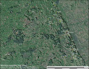
English: Shaded relief map of the location of the 53 extant Dutch 'hunebedden' (dolmens). Altitudes have been exaggerated by a factor 20 to show the relief. It can be seen that most dolmens are located on higher ground (the Hondsrug ice-pushed ridge). Map based on a 3" SRTM DEM and Landsat imagery.
Nederlands: Reliëfkaart met de lokaties van de 53 nog bestaande Nederlandse hunebedden. De hoogtes zijn hier een faktor 20 overdreven om het reliëf goed tot uitdrukking te brengen. Te zien is dat de meeste hunebedden in de hogere delen van het landschap liggen (de Hondsrug, een stuw-wallen complex) |
| Date | |
| Source | Own work |
| Author | Marcoaliaslama |
Licensing
I, the copyright holder of this work, hereby publish it under the following licenses:
This file is licensed under the
Creative Commons
Attribution-Share Alike 3.0 Unported license.
- You are free:
- to share – to copy, distribute and transmit the work
- to remix – to adapt the work
- Under the following conditions:
- attribution – You must give appropriate credit, provide a link to the license, and indicate if changes were made. You may do so in any reasonable manner, but not in any way that suggests the licensor endorses you or your use.
- share alike – If you remix, transform, or build upon the material, you must distribute your contributions under the same or compatible license as the original.

|
Permission is granted to copy, distribute and/or modify this document under the terms of the GNU Free Documentation License, Version 1.2 or any later version published by the Free Software Foundation; with no Invariant Sections, no Front-Cover Texts, and no Back-Cover Texts. A copy of the license is included in the section entitled GNU Free Documentation License. |
You may select the license of your choice.
File history
Click on a date/time to view the file as it appeared at that time.
| Date/Time | Thumbnail | Dimensions | User | Comment | |
|---|---|---|---|---|---|
| current | 06:15, 6 July 2009 |
| 777 × 601 (213 KB) | Marcoaliaslama | {{Information |Description={{en|1=Shaded relief map of the location of the 53 extant Dutch 'hunebedden' (dolmens). Altitudes have been exaggerated by a factor 20 to show the relief. It can be seen that most dolmens are located on higher ground (the Hondsr |
File usage
The following pages on the English Wikipedia use this file (pages on other projects are not listed):
Global file usage
The following other wikis use this file:
- Usage on de.wikipedia.org
- Usage on fr.wikipedia.org
- Usage on kk.wikipedia.org
- Usage on nl.wikipedia.org
Metadata
Size of this preview:
775 × 599 pixels. Other resolutions:
310 × 240 pixels |
621 × 480 pixels |
777 × 601 pixels.
Original file (777 × 601 pixels, file size: 213 KB, MIME type: image/jpeg)
| This is a file from the
Wikimedia Commons. Information from its
description page there is shown below. Commons is a freely licensed media file repository. You can help. |
Summary
| Description |
English: Shaded relief map of the location of the 53 extant Dutch 'hunebedden' (dolmens). Altitudes have been exaggerated by a factor 20 to show the relief. It can be seen that most dolmens are located on higher ground (the Hondsrug ice-pushed ridge). Map based on a 3" SRTM DEM and Landsat imagery.
Nederlands: Reliëfkaart met de lokaties van de 53 nog bestaande Nederlandse hunebedden. De hoogtes zijn hier een faktor 20 overdreven om het reliëf goed tot uitdrukking te brengen. Te zien is dat de meeste hunebedden in de hogere delen van het landschap liggen (de Hondsrug, een stuw-wallen complex) |
| Date | |
| Source | Own work |
| Author | Marcoaliaslama |
Licensing
I, the copyright holder of this work, hereby publish it under the following licenses:
This file is licensed under the
Creative Commons
Attribution-Share Alike 3.0 Unported license.
- You are free:
- to share – to copy, distribute and transmit the work
- to remix – to adapt the work
- Under the following conditions:
- attribution – You must give appropriate credit, provide a link to the license, and indicate if changes were made. You may do so in any reasonable manner, but not in any way that suggests the licensor endorses you or your use.
- share alike – If you remix, transform, or build upon the material, you must distribute your contributions under the same or compatible license as the original.
|
|
Permission is granted to copy, distribute and/or modify this document under the terms of the GNU Free Documentation License, Version 1.2 or any later version published by the Free Software Foundation; with no Invariant Sections, no Front-Cover Texts, and no Back-Cover Texts. A copy of the license is included in the section entitled GNU Free Documentation License. |
You may select the license of your choice.
File history
Click on a date/time to view the file as it appeared at that time.
| Date/Time | Thumbnail | Dimensions | User | Comment | |
|---|---|---|---|---|---|
| current | 06:15, 6 July 2009 |
| 777 × 601 (213 KB) | Marcoaliaslama | {{Information |Description={{en|1=Shaded relief map of the location of the 53 extant Dutch 'hunebedden' (dolmens). Altitudes have been exaggerated by a factor 20 to show the relief. It can be seen that most dolmens are located on higher ground (the Hondsr |
File usage
The following pages on the English Wikipedia use this file (pages on other projects are not listed):
Global file usage
The following other wikis use this file:
- Usage on de.wikipedia.org
- Usage on fr.wikipedia.org
- Usage on kk.wikipedia.org
- Usage on nl.wikipedia.org