
Size of this preview:
390 × 599 pixels. Other resolutions:
156 × 240 pixels |
312 × 480 pixels |
651 × 1,000 pixels.
Original file (651 × 1,000 pixels, file size: 121 KB, MIME type: image/png)
| This is a file from the
Wikimedia Commons. Information from its
description page there is shown below. Commons is a freely licensed media file repository. You can help. |
| Description |
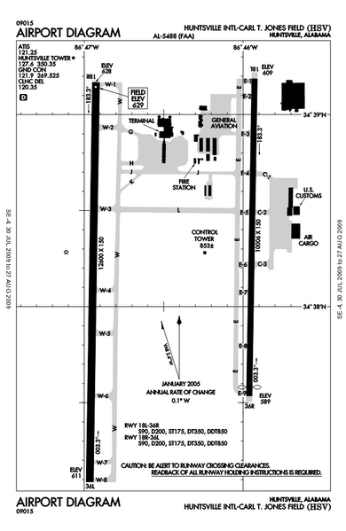
English: FAA airport diagram for
Huntsville International Airport (HSV) in Huntsville, Alabama, United States. |
|||
| Date | Effective 2009-07-30 to 2009-08-27. | |||
| Source |
http://naco.faa.gov/d-tpp/0908/05488AD.PDF Note: this URL changes every 28 days; the airport article should contain a link to the current FAA diagram. |
|||
| Author | Produced by the National Aeronautical Charting Office (NACO), a department of the Federal Aviation Administration (FAA). | |||
| Permission ( Reusing this file) |
|

File history
Click on a date/time to view the file as it appeared at that time.
| Date/Time | Thumbnail | Dimensions | User | Comment | |
|---|---|---|---|---|---|
| current | 04:54, 9 August 2009 |
| 651 × 1,000 (121 KB) | Spyder Monkey | {{Information | Description = {{en|FAA airport diagram for {{w|Huntsville International Airport}} (HSV) in Huntsville, Alabama, United States.}} | Source = http://naco.faa.gov/d-tpp/0908/05488AD.PDF<br>Note: this URL changes [[:en:Aeronautical Information |
File usage
The following pages on the English Wikipedia use this file (pages on other projects are not listed):
Global file usage
The following other wikis use this file:
- Usage on es.wikipedia.org
- Usage on www.wikidata.org
Size of this preview:
390 × 599 pixels. Other resolutions:
156 × 240 pixels |
312 × 480 pixels |
651 × 1,000 pixels.
Original file (651 × 1,000 pixels, file size: 121 KB, MIME type: image/png)
| This is a file from the
Wikimedia Commons. Information from its
description page there is shown below. Commons is a freely licensed media file repository. You can help. |
| Description |
English: FAA airport diagram for
Huntsville International Airport (HSV) in Huntsville, Alabama, United States. |
|||
| Date | Effective 2009-07-30 to 2009-08-27. | |||
| Source |
http://naco.faa.gov/d-tpp/0908/05488AD.PDF Note: this URL changes every 28 days; the airport article should contain a link to the current FAA diagram. |
|||
| Author | Produced by the National Aeronautical Charting Office (NACO), a department of the Federal Aviation Administration (FAA). | |||
| Permission ( Reusing this file) |
|
File history
Click on a date/time to view the file as it appeared at that time.
| Date/Time | Thumbnail | Dimensions | User | Comment | |
|---|---|---|---|---|---|
| current | 04:54, 9 August 2009 |
| 651 × 1,000 (121 KB) | Spyder Monkey | {{Information | Description = {{en|FAA airport diagram for {{w|Huntsville International Airport}} (HSV) in Huntsville, Alabama, United States.}} | Source = http://naco.faa.gov/d-tpp/0908/05488AD.PDF<br>Note: this URL changes [[:en:Aeronautical Information |
File usage
The following pages on the English Wikipedia use this file (pages on other projects are not listed):
Global file usage
The following other wikis use this file:
- Usage on es.wikipedia.org
- Usage on www.wikidata.org