HMSO_Graf_Spee_map_of_River_Plate.jpg (751 × 517 pixels, file size: 57 KB, MIME type: image/jpeg)
| This is a file from the
Wikimedia Commons. Information from its
description page there is shown below. Commons is a freely licensed media file repository. You can help. |
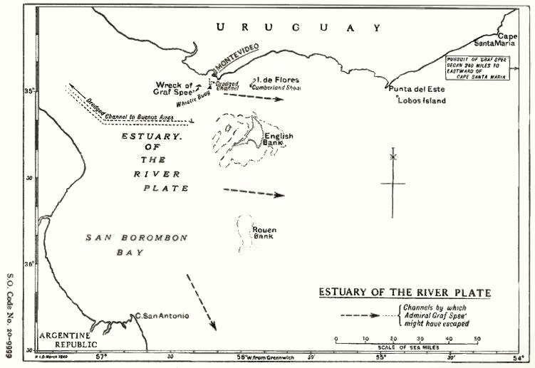
| Description | Map of the estuary of the River Plate showing possible exit channels available to the German heavy cruiser Admiral Graf Spee after the Battle of the River Plate in December 1939. | |||
| Date | ||||
| Source |
From official British report into the cruise of the Graf Spee and Battle of the River Plate. Published by HMSO (His Majesty's Stationery Office). Originally uploaded to EN Wikipedia as en:File:HMSO Graf Spee map of River Plate.jpg by en:User:Duncharris 26 December 2004; modified by en:User:Lhgodoy 22 March 2006. |
|||
| Author | British Government | |||
| Permission ( Reusing this file) |
Crown Copyright expired (50 years)
|
|||
| Other versions | en:File:HMSO Graf Spee map of River Plate.jpg |

File history
Click on a date/time to view the file as it appeared at that time.
| Date/Time | Thumbnail | Dimensions | User | Comment | |
|---|---|---|---|---|---|
| current | 17:05, 20 December 2009 |
| 751 × 517 (57 KB) | Rcbutcher | {{Information |Description=Map of the estuary of the River Plate showing possible exit channels available to the German heavy cruiser Admiral Graf Spee after the Battle of the River Plate in December 1939. |Source=From official British report into the cru |
File usage
Global file usage
The following other wikis use this file:
- Usage on azb.wikipedia.org
- Usage on ca.wikipedia.org
- Usage on de.wikipedia.org
- Usage on es.wikipedia.org
- Usage on hu.wikipedia.org
- Usage on it.wikipedia.org
- Usage on nl.wikipedia.org
Metadata
HMSO_Graf_Spee_map_of_River_Plate.jpg (751 × 517 pixels, file size: 57 KB, MIME type: image/jpeg)
| This is a file from the
Wikimedia Commons. Information from its
description page there is shown below. Commons is a freely licensed media file repository. You can help. |
| Description | Map of the estuary of the River Plate showing possible exit channels available to the German heavy cruiser Admiral Graf Spee after the Battle of the River Plate in December 1939. | |||
| Date | ||||
| Source |
From official British report into the cruise of the Graf Spee and Battle of the River Plate. Published by HMSO (His Majesty's Stationery Office). Originally uploaded to EN Wikipedia as en:File:HMSO Graf Spee map of River Plate.jpg by en:User:Duncharris 26 December 2004; modified by en:User:Lhgodoy 22 March 2006. |
|||
| Author | British Government | |||
| Permission ( Reusing this file) |
Crown Copyright expired (50 years)
|
|||
| Other versions | en:File:HMSO Graf Spee map of River Plate.jpg |
File history
Click on a date/time to view the file as it appeared at that time.
| Date/Time | Thumbnail | Dimensions | User | Comment | |
|---|---|---|---|---|---|
| current | 17:05, 20 December 2009 |
| 751 × 517 (57 KB) | Rcbutcher | {{Information |Description=Map of the estuary of the River Plate showing possible exit channels available to the German heavy cruiser Admiral Graf Spee after the Battle of the River Plate in December 1939. |Source=From official British report into the cru |
File usage
Global file usage
The following other wikis use this file:
- Usage on azb.wikipedia.org
- Usage on ca.wikipedia.org
- Usage on de.wikipedia.org
- Usage on es.wikipedia.org
- Usage on hu.wikipedia.org
- Usage on it.wikipedia.org
- Usage on nl.wikipedia.org