
Size of this PNG preview of this SVG file:
800 × 566 pixels. Other resolutions:
320 × 226 pixels |
640 × 453 pixels |
1,024 × 724 pixels |
1,280 × 905 pixels |
2,560 × 1,810 pixels |
1,052 × 744 pixels.
Original file (SVG file, nominally 1,052 × 744 pixels, file size: 1.26 MB)
| This is a file from the
Wikimedia Commons. Information from its
description page there is shown below. Commons is a freely licensed media file repository. You can help. |
Summary
| Description |
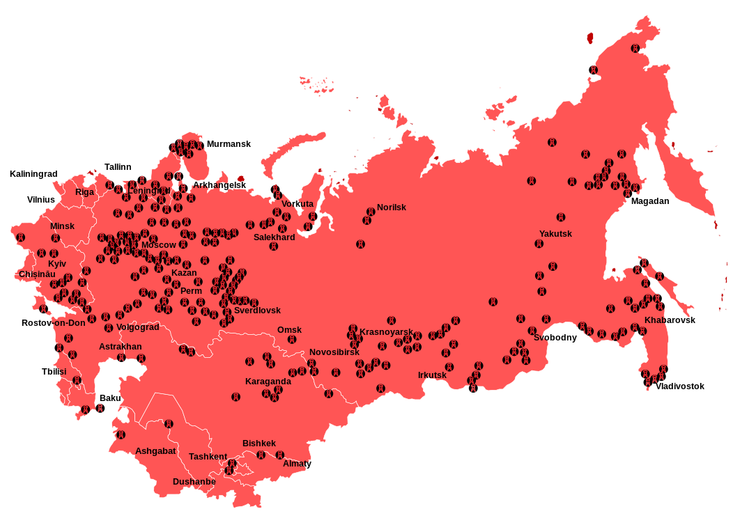
English: Location map of Soviet
Gulag system concentration camps
Русский: Карта расположения исправительно-трудовых лагерей
ГУЛаг в Союзе ССР. |
| Date | |
| Source | Собственная работа, основанная на материалах справочника « Система исправительно-трудовых лагерей в СССР», подготовленного правозащитным обществом « Мемориал». |
| Author | Antonu |
| Other versions |
|
| SVG development |
Licensing
I, the copyright holder of this work, hereby publish it under the following licenses:
This file is licensed under the
Creative Commons
Attribution-Share Alike 3.0 Unported license.
- You are free:
- to share – to copy, distribute and transmit the work
- to remix – to adapt the work
- Under the following conditions:
- attribution – You must give appropriate credit, provide a link to the license, and indicate if changes were made. You may do so in any reasonable manner, but not in any way that suggests the licensor endorses you or your use.
- share alike – If you remix, transform, or build upon the material, you must distribute your contributions under the same or compatible license as the original.

|
Permission is granted to copy, distribute and/or modify this document under the terms of the GNU Free Documentation License, Version 1.2 or any later version published by the Free Software Foundation; with no Invariant Sections, no Front-Cover Texts, and no Back-Cover Texts. A copy of the license is included in the section entitled GNU Free Documentation License. |
You may select the license of your choice.
File history
Click on a date/time to view the file as it appeared at that time.
| Date/Time | Thumbnail | Dimensions | User | Comment | |
|---|---|---|---|---|---|
| current | 03:22, 20 March 2024 |
| 1,052 × 744 (1.26 MB) | Saurmandal | EN correction // Editing SVG source code using c:User:Rillke/SVGedit.js |
| 03:20, 20 March 2024 |
 | 1,052 × 744 (1.26 MB) | Saurmandal | File uploaded using svgtranslate tool (https://svgtranslate.toolforge.org/). Added translation for hi. | |
| 03:07, 20 March 2024 |
 | 1,052 × 744 (1.25 MB) | Saurmandal | File uploaded using svgtranslate tool (https://svgtranslate.toolforge.org/). Added translation for en. | |
| 20:40, 17 October 2022 |
 | 1,052 × 744 (1.24 MB) | Archiwald | File uploaded using svgtranslate tool (https://svgtranslate.toolforge.org/). Added translation for pl. | |
| 17:18, 23 August 2016 |
 | 1,052 × 744 (1.25 MB) | Hohum | Clearer with lighter background | |
| 09:27, 26 July 2016 |
 | 1,052 × 744 (1.65 MB) | Nicolay Sidorov | + border between Ukraine and RSFSR in Crimea, + border between RSFSR and Karelo-Finnish SSR | |
| 19:19, 16 August 2011 |
 | 1,052 × 744 (1.53 MB) | Antonu | Embedded text | |
| 16:14, 16 August 2011 |
 | 1,052 × 744 (1.18 MB) | Antonu | {{Information |Description={{en|1=Location map of soviet Gulag system concentration camps}} {{ru|1=Карта расположения концентрационных лагерей системы ГУЛаг}} |Source=С� |
File usage
The following pages on the English Wikipedia use this file (pages on other projects are not listed):
Global file usage
The following other wikis use this file:
- Usage on ast.wikipedia.org
- Usage on az.wikipedia.org
- Usage on ba.wikipedia.org
- Usage on ca.wikipedia.org
- Usage on cs.wikipedia.org
- Usage on da.wikipedia.org
- Usage on de.wikipedia.org
- Usage on el.wikipedia.org
- Usage on eo.wikipedia.org
- Usage on eu.wikipedia.org
- Usage on fi.wikipedia.org
- Usage on fi.wikibooks.org
- Usage on fr.wikipedia.org
- Usage on ga.wikipedia.org
- Usage on gl.wikipedia.org
- Usage on he.wikipedia.org
- Usage on hi.wikipedia.org
- Usage on hu.wikipedia.org
- Usage on hy.wikipedia.org
- Usage on ja.wikipedia.org
- Usage on lt.wikipedia.org
- Usage on lv.wikipedia.org
- Usage on mk.wikipedia.org
- Usage on ms.wikipedia.org
- Usage on nl.wikipedia.org
- Usage on no.wikipedia.org
- Usage on pa.wikipedia.org
- Usage on pl.wikipedia.org
- Usage on pnb.wikipedia.org
- Usage on ro.wikipedia.org
- Usage on rue.wikipedia.org
- Usage on ru.wikipedia.org
- Usage on sk.wikipedia.org
- Usage on th.wikipedia.org
- Usage on tum.wikipedia.org
View more global usage of this file.
Metadata
Size of this PNG preview of this SVG file:
800 × 566 pixels. Other resolutions:
320 × 226 pixels |
640 × 453 pixels |
1,024 × 724 pixels |
1,280 × 905 pixels |
2,560 × 1,810 pixels |
1,052 × 744 pixels.
Original file (SVG file, nominally 1,052 × 744 pixels, file size: 1.26 MB)
| This is a file from the
Wikimedia Commons. Information from its
description page there is shown below. Commons is a freely licensed media file repository. You can help. |
Summary
| Description |
English: Location map of Soviet
Gulag system concentration camps
Русский: Карта расположения исправительно-трудовых лагерей
ГУЛаг в Союзе ССР. |
| Date | |
| Source | Собственная работа, основанная на материалах справочника « Система исправительно-трудовых лагерей в СССР», подготовленного правозащитным обществом « Мемориал». |
| Author | Antonu |
| Other versions |
|
| SVG development |
Licensing
I, the copyright holder of this work, hereby publish it under the following licenses:
This file is licensed under the
Creative Commons
Attribution-Share Alike 3.0 Unported license.
- You are free:
- to share – to copy, distribute and transmit the work
- to remix – to adapt the work
- Under the following conditions:
- attribution – You must give appropriate credit, provide a link to the license, and indicate if changes were made. You may do so in any reasonable manner, but not in any way that suggests the licensor endorses you or your use.
- share alike – If you remix, transform, or build upon the material, you must distribute your contributions under the same or compatible license as the original.
|
|
Permission is granted to copy, distribute and/or modify this document under the terms of the GNU Free Documentation License, Version 1.2 or any later version published by the Free Software Foundation; with no Invariant Sections, no Front-Cover Texts, and no Back-Cover Texts. A copy of the license is included in the section entitled GNU Free Documentation License. |
You may select the license of your choice.
File history
Click on a date/time to view the file as it appeared at that time.
| Date/Time | Thumbnail | Dimensions | User | Comment | |
|---|---|---|---|---|---|
| current | 03:22, 20 March 2024 |
| 1,052 × 744 (1.26 MB) | Saurmandal | EN correction // Editing SVG source code using c:User:Rillke/SVGedit.js |
| 03:20, 20 March 2024 |
| 1,052 × 744 (1.26 MB) | Saurmandal | File uploaded using svgtranslate tool (https://svgtranslate.toolforge.org/). Added translation for hi. | |
| 03:07, 20 March 2024 |
| 1,052 × 744 (1.25 MB) | Saurmandal | File uploaded using svgtranslate tool (https://svgtranslate.toolforge.org/). Added translation for en. | |
| 20:40, 17 October 2022 |
| 1,052 × 744 (1.24 MB) | Archiwald | File uploaded using svgtranslate tool (https://svgtranslate.toolforge.org/). Added translation for pl. | |
| 17:18, 23 August 2016 |
| 1,052 × 744 (1.25 MB) | Hohum | Clearer with lighter background | |
| 09:27, 26 July 2016 |
| 1,052 × 744 (1.65 MB) | Nicolay Sidorov | + border between Ukraine and RSFSR in Crimea, + border between RSFSR and Karelo-Finnish SSR | |
| 19:19, 16 August 2011 |
| 1,052 × 744 (1.53 MB) | Antonu | Embedded text | |
| 16:14, 16 August 2011 |
| 1,052 × 744 (1.18 MB) | Antonu | {{Information |Description={{en|1=Location map of soviet Gulag system concentration camps}} {{ru|1=Карта расположения концентрационных лагерей системы ГУЛаг}} |Source=С� |
File usage
The following pages on the English Wikipedia use this file (pages on other projects are not listed):
Global file usage
The following other wikis use this file:
- Usage on ast.wikipedia.org
- Usage on az.wikipedia.org
- Usage on ba.wikipedia.org
- Usage on ca.wikipedia.org
- Usage on cs.wikipedia.org
- Usage on da.wikipedia.org
- Usage on de.wikipedia.org
- Usage on el.wikipedia.org
- Usage on eo.wikipedia.org
- Usage on eu.wikipedia.org
- Usage on fi.wikipedia.org
- Usage on fi.wikibooks.org
- Usage on fr.wikipedia.org
- Usage on ga.wikipedia.org
- Usage on gl.wikipedia.org
- Usage on he.wikipedia.org
- Usage on hi.wikipedia.org
- Usage on hu.wikipedia.org
- Usage on hy.wikipedia.org
- Usage on ja.wikipedia.org
- Usage on lt.wikipedia.org
- Usage on lv.wikipedia.org
- Usage on mk.wikipedia.org
- Usage on ms.wikipedia.org
- Usage on nl.wikipedia.org
- Usage on no.wikipedia.org
- Usage on pa.wikipedia.org
- Usage on pl.wikipedia.org
- Usage on pnb.wikipedia.org
- Usage on ro.wikipedia.org
- Usage on rue.wikipedia.org
- Usage on ru.wikipedia.org
- Usage on sk.wikipedia.org
- Usage on th.wikipedia.org
- Usage on tum.wikipedia.org
View more global usage of this file.