Photos • Location


Size of this preview:
800 × 449 pixels. Other resolutions:
320 × 180 pixels |
640 × 359 pixels |
948 × 532 pixels.
Original file (948 × 532 pixels, file size: 49 KB, MIME type: image/jpeg)
| This is a file from the
Wikimedia Commons. Information from its
description page there is shown below. Commons is a freely licensed media file repository. You can help. |
Summary
| Description |
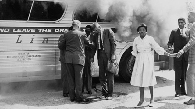
English:
Freedom Riders stand next to a bruning Greyhound bus after it was firebombed by a
Ku Klux Klan mob outside of
Anniston, Alabama. 14 May 1961. |
| Date | |
| Source | https://npgallery.nps.gov/AssetDetail/f35c833e96e7439e9aa2c71e6a8ecfee |
| Author | U.S. National Park Service |
| Camera location |
| View this and other nearby images on: OpenStreetMap |
|
|---|
Licensing
| This file is made available under the Creative Commons CC0 1.0 Universal Public Domain Dedication. | |
| The person who associated a work with this deed has dedicated the work to the
public domain by waiving all of their rights to the work worldwide under copyright law, including all related and neighboring rights, to the extent allowed by law. You can copy, modify, distribute and perform the work, even for commercial purposes, all without asking permission.
|
File history
Click on a date/time to view the file as it appeared at that time.
| Date/Time | Thumbnail | Dimensions | User | Comment | |
|---|---|---|---|---|---|
| current | 10:45, 3 April 2023 |
| 948 × 532 (49 KB) | PentagonPizza | Uploaded a work by U.S. National Park Service from https://npgallery.nps.gov/AssetDetail/f35c833e96e7439e9aa2c71e6a8ecfee with UploadWizard |
File usage
The following pages on the English Wikipedia use this file (pages on other projects are not listed):
Size of this preview:
800 × 449 pixels. Other resolutions:
320 × 180 pixels |
640 × 359 pixels |
948 × 532 pixels.
Original file (948 × 532 pixels, file size: 49 KB, MIME type: image/jpeg)
| This is a file from the
Wikimedia Commons. Information from its
description page there is shown below. Commons is a freely licensed media file repository. You can help. |
Summary
| Description |
English:
Freedom Riders stand next to a bruning Greyhound bus after it was firebombed by a
Ku Klux Klan mob outside of
Anniston, Alabama. 14 May 1961. |
| Date | |
| Source | https://npgallery.nps.gov/AssetDetail/f35c833e96e7439e9aa2c71e6a8ecfee |
| Author | U.S. National Park Service |
| Camera location |
| View this and other nearby images on: OpenStreetMap |
|
|---|
Licensing
| This file is made available under the Creative Commons CC0 1.0 Universal Public Domain Dedication. | |
| The person who associated a work with this deed has dedicated the work to the
public domain by waiving all of their rights to the work worldwide under copyright law, including all related and neighboring rights, to the extent allowed by law. You can copy, modify, distribute and perform the work, even for commercial purposes, all without asking permission.
|
File history
Click on a date/time to view the file as it appeared at that time.
| Date/Time | Thumbnail | Dimensions | User | Comment | |
|---|---|---|---|---|---|
| current | 10:45, 3 April 2023 |
| 948 × 532 (49 KB) | PentagonPizza | Uploaded a work by U.S. National Park Service from https://npgallery.nps.gov/AssetDetail/f35c833e96e7439e9aa2c71e6a8ecfee with UploadWizard |
File usage
The following pages on the English Wikipedia use this file (pages on other projects are not listed):