Size of this preview:
468 × 600 pixels. Other resolutions:
187 × 240 pixels |
374 × 480 pixels |
599 × 768 pixels |
799 × 1,024 pixels |
2,526 × 3,238 pixels.
Original file (2,526 × 3,238 pixels, file size: 3.64 MB, MIME type: image/jpeg)
| This is a file from the
Wikimedia Commons. Information from its
description page there is shown below. Commons is a freely licensed media file repository. You can help. |
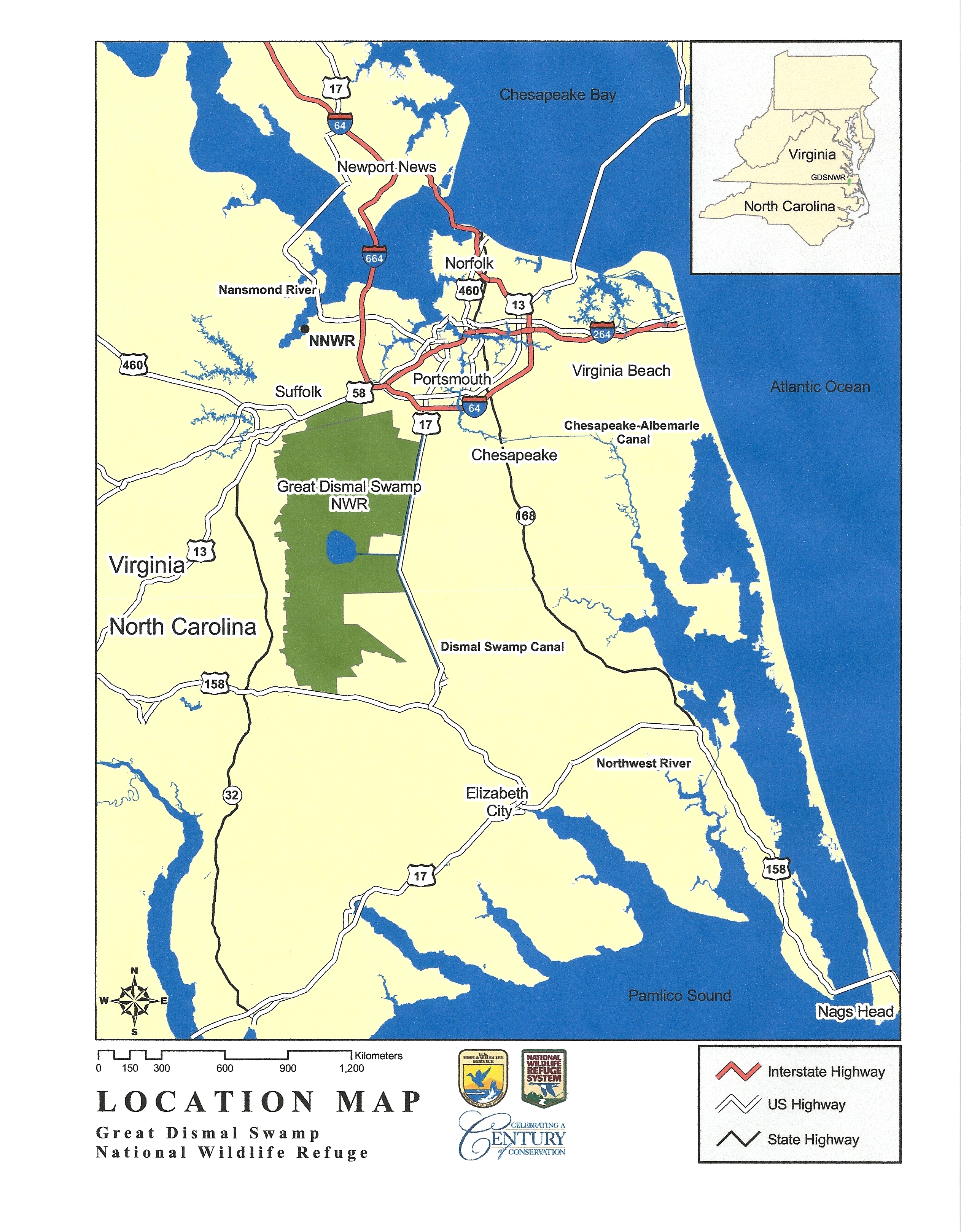
| Description | Map of the Great Dismal Swamp, in Virginia and North Carolina, USA | |||
| Date | Unknown date | |||
| Source | US Fish and Wildlife Service - http://www.fws.gov/northeast/greatdismalswamp/pdf/LocationMap8by11.pdf | |||
| Author | US Fish and Wildlife Service | |||
| Permission ( Reusing this file) |
|
|||
| Other versions |

.jpg)

|
This map image could be re-created using
vector graphics as an
SVG file. This has several advantages; see
Commons:Media for cleanup for more information. If an SVG form of this image is available, please upload it and afterwards replace this template with
{{
vector version available|new image name}}
.
It is recommended to name the SVG file “GreatDismalSwampMap.svg”—then the template Vector version available (or Vva) does not need the new image name parameter. |


File history
Click on a date/time to view the file as it appeared at that time.
| Date/Time | Thumbnail | Dimensions | User | Comment | |
|---|---|---|---|---|---|
| current | 00:22, 13 March 2023 |
| 2,526 × 3,238 (3.64 MB) | Smasongarrison | Cropped 7 % vertically using CropTool with lossless mode. |
| 22:15, 18 August 2011 |
 | 2,526 × 3,484 (3.25 MB) | PumpkinSky | {{Information |Description=Map of the Great Dismal Swamp, in Virginia and North Carolina, USA |Source=US Fish and Wildlife Service - http://www.fws.gov/northeast/greatdismalswamp/pdf/LocationMap8by11.pdf |Date= unknown |Author=US Fish and Wildlife Service |
File usage
The following pages on the English Wikipedia use this file (pages on other projects are not listed):
Global file usage
The following other wikis use this file:
- Usage on nl.wikipedia.org
Metadata
Size of this preview:
468 × 600 pixels. Other resolutions:
187 × 240 pixels |
374 × 480 pixels |
599 × 768 pixels |
799 × 1,024 pixels |
2,526 × 3,238 pixels.
Original file (2,526 × 3,238 pixels, file size: 3.64 MB, MIME type: image/jpeg)
| This is a file from the
Wikimedia Commons. Information from its
description page there is shown below. Commons is a freely licensed media file repository. You can help. |
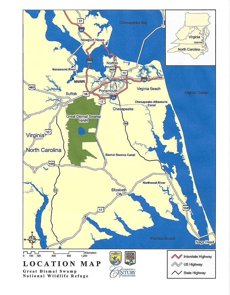
| Description | Map of the Great Dismal Swamp, in Virginia and North Carolina, USA | |||
| Date | Unknown date | |||
| Source | US Fish and Wildlife Service - http://www.fws.gov/northeast/greatdismalswamp/pdf/LocationMap8by11.pdf | |||
| Author | US Fish and Wildlife Service | |||
| Permission ( Reusing this file) |
|
|||
| Other versions |
|
|
This map image could be re-created using
vector graphics as an
SVG file. This has several advantages; see
Commons:Media for cleanup for more information. If an SVG form of this image is available, please upload it and afterwards replace this template with
{{
vector version available|new image name}}
.
It is recommended to name the SVG file “GreatDismalSwampMap.svg”—then the template Vector version available (or Vva) does not need the new image name parameter. |
File history
Click on a date/time to view the file as it appeared at that time.
| Date/Time | Thumbnail | Dimensions | User | Comment | |
|---|---|---|---|---|---|
| current | 00:22, 13 March 2023 |
| 2,526 × 3,238 (3.64 MB) | Smasongarrison | Cropped 7 % vertically using CropTool with lossless mode. |
| 22:15, 18 August 2011 |
| 2,526 × 3,484 (3.25 MB) | PumpkinSky | {{Information |Description=Map of the Great Dismal Swamp, in Virginia and North Carolina, USA |Source=US Fish and Wildlife Service - http://www.fws.gov/northeast/greatdismalswamp/pdf/LocationMap8by11.pdf |Date= unknown |Author=US Fish and Wildlife Service |
File usage
The following pages on the English Wikipedia use this file (pages on other projects are not listed):
Global file usage
The following other wikis use this file:
- Usage on nl.wikipedia.org