Size of this preview:
418 × 599 pixels. Other resolutions:
167 × 240 pixels |
606 × 868 pixels.
Original file (606 × 868 pixels, file size: 217 KB, MIME type: image/png)
| This is a file from the
Wikimedia Commons. Information from its
description page there is shown below. Commons is a freely licensed media file repository. You can help. |

|
This linguistic map image could be re-created using
vector graphics as an
SVG file. This has several advantages; see
Commons:Media for cleanup for more information. If an SVG form of this image is available, please upload it and afterwards replace this template with
{{
vector version available|new image name}}
.
It is recommended to name the SVG file “Geographical distribution of extant Slavic and East Baltic languages 2015.svg”—then the template Vector version available (or Vva) does not need the new image name parameter. |
Summary
| Description |
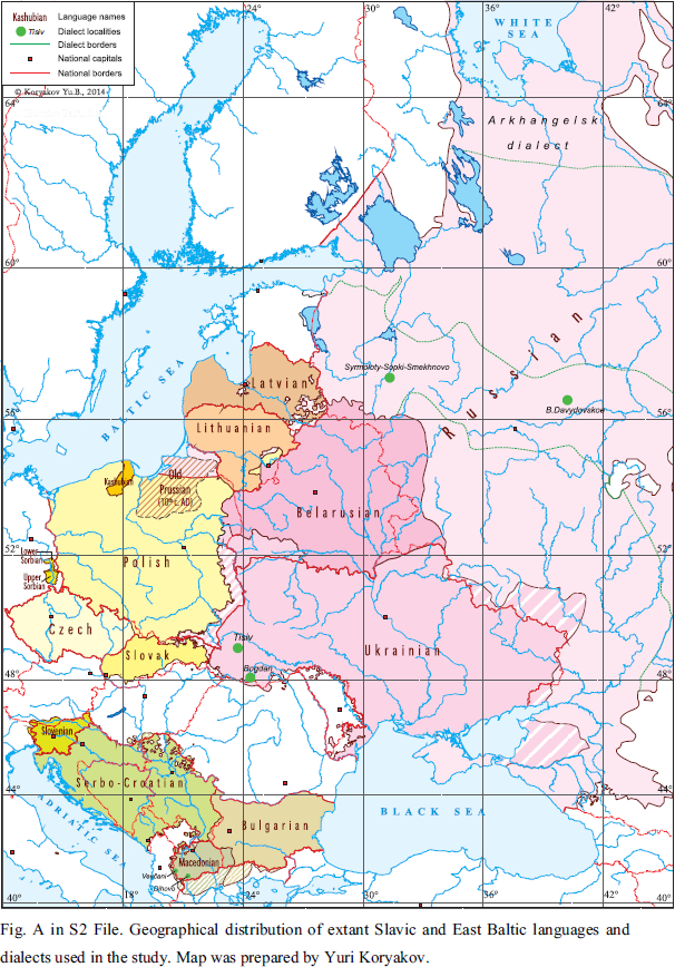
English: Ethnic map Belorussian, Bulgarian, Czech, Kashubian, Lithuanian, Latvian, Macedonian, Polish, Russian, Serbo-Croatian, Slovak, Slovenian, Sorbian, Ukrainian
Українська: Етнічна карта білоруська, болгарська, чеська, кашубська, литовська, латиська, македонська, польська, російська, сербо-хорватська, словацька, лужицька, українська
Русский: Этническая карта белорусский, болгарский, чешский, кашубский, литовский, латышский, македонский, польский, русский, сербо-хорватский, словацкий, лужицкая, украинский |
| Date | |
| Source |
https://journals.plos.org/plosone/article?id=10.1371/journal.pone.0135820#sec021 Fig A in S2 File. Geographical distribution of extant Slavic and East Baltic languages and dialects used in the study. Map was prepared by Yuri Koryakov. |
| Author | Yuri Koryakov |
Licensing
This file is licensed under the
Creative Commons
Attribution 4.0 International license.
- You are free:
- to share – to copy, distribute and transmit the work
- to remix – to adapt the work
- Under the following conditions:
- attribution – You must give appropriate credit, provide a link to the license, and indicate if changes were made. You may do so in any reasonable manner, but not in any way that suggests the licensor endorses you or your use.
File history
Click on a date/time to view the file as it appeared at that time.
| Date/Time | Thumbnail | Dimensions | User | Comment | |
|---|---|---|---|---|---|
| current | 13:58, 19 May 2020 |
| 606 × 868 (217 KB) | KKonstantin | Uploaded a work by Yuri Koryakov from https://journals.plos.org/plosone/article?id=10.1371/journal.pone.0135820#sec021 Fig A in S2 File. Geographical distribution of extant Slavic and East Baltic languages and dialects used in the study. Map was prepared by Yuri Koryakov. with UploadWizard |
File usage
The following pages on the English Wikipedia use this file (pages on other projects are not listed):
Global file usage
The following other wikis use this file:
- Usage on fr.wikipedia.org
- Usage on ko.wikipedia.org
- Usage on rw.wikipedia.org
- Usage on sl.wikipedia.org
- Usage on uk.wikipedia.org
Metadata
Size of this preview:
418 × 599 pixels. Other resolutions:
167 × 240 pixels |
606 × 868 pixels.
Original file (606 × 868 pixels, file size: 217 KB, MIME type: image/png)
| This is a file from the
Wikimedia Commons. Information from its
description page there is shown below. Commons is a freely licensed media file repository. You can help. |
|
|
This linguistic map image could be re-created using
vector graphics as an
SVG file. This has several advantages; see
Commons:Media for cleanup for more information. If an SVG form of this image is available, please upload it and afterwards replace this template with
{{
vector version available|new image name}}
.
It is recommended to name the SVG file “Geographical distribution of extant Slavic and East Baltic languages 2015.svg”—then the template Vector version available (or Vva) does not need the new image name parameter. |
Summary
| Description |
English: Ethnic map Belorussian, Bulgarian, Czech, Kashubian, Lithuanian, Latvian, Macedonian, Polish, Russian, Serbo-Croatian, Slovak, Slovenian, Sorbian, Ukrainian
Українська: Етнічна карта білоруська, болгарська, чеська, кашубська, литовська, латиська, македонська, польська, російська, сербо-хорватська, словацька, лужицька, українська
Русский: Этническая карта белорусский, болгарский, чешский, кашубский, литовский, латышский, македонский, польский, русский, сербо-хорватский, словацкий, лужицкая, украинский |
| Date | |
| Source |
https://journals.plos.org/plosone/article?id=10.1371/journal.pone.0135820#sec021 Fig A in S2 File. Geographical distribution of extant Slavic and East Baltic languages and dialects used in the study. Map was prepared by Yuri Koryakov. |
| Author | Yuri Koryakov |
Licensing
This file is licensed under the
Creative Commons
Attribution 4.0 International license.
- You are free:
- to share – to copy, distribute and transmit the work
- to remix – to adapt the work
- Under the following conditions:
- attribution – You must give appropriate credit, provide a link to the license, and indicate if changes were made. You may do so in any reasonable manner, but not in any way that suggests the licensor endorses you or your use.
File history
Click on a date/time to view the file as it appeared at that time.
| Date/Time | Thumbnail | Dimensions | User | Comment | |
|---|---|---|---|---|---|
| current | 13:58, 19 May 2020 |
| 606 × 868 (217 KB) | KKonstantin | Uploaded a work by Yuri Koryakov from https://journals.plos.org/plosone/article?id=10.1371/journal.pone.0135820#sec021 Fig A in S2 File. Geographical distribution of extant Slavic and East Baltic languages and dialects used in the study. Map was prepared by Yuri Koryakov. with UploadWizard |
File usage
The following pages on the English Wikipedia use this file (pages on other projects are not listed):
Global file usage
The following other wikis use this file:
- Usage on fr.wikipedia.org
- Usage on ko.wikipedia.org
- Usage on rw.wikipedia.org
- Usage on sl.wikipedia.org
- Usage on uk.wikipedia.org