
Original file (SVG file, nominally 938 ├Ś 810 pixels, file size: 1.77 MB)
| This is a file from the
Wikimedia Commons. Information from its
description page there is shown below. Commons is a freely licensed media file repository. You can help. |
.svg)
Summary
| Description |
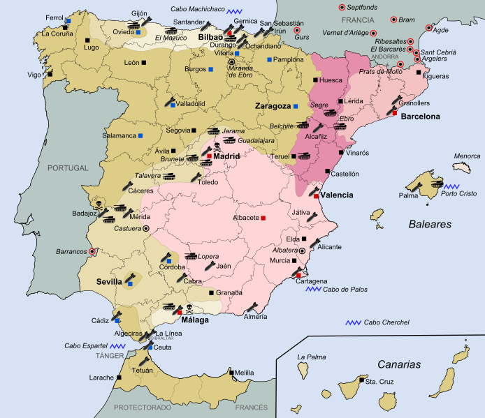
Espa├▒ol: Mapa general de la Guerra Civil Espa├▒ola (1936-1939).
Zona sublevada inicial - julio 1936
Avance sublevado hasta septiembre de 1936
Avance sublevado hasta octubre de 1937
Avance sublevado hasta noviembre de 1938
Avance sublevado hasta febrero de 1939
Última zona bajo control republicano
English: General map of the Spanish Civil War (1936-1939).
Initial Rebel zone - July 1936
Rebel advance until September 1936
Rebel advance until October 1937
Rebel advance until November 1938
Rebel advance until February 1939
Last area under Republican control
õĖŁµ¢ć’╝Ü1936Õ╣┤Ķć│1939Õ╣┤Ķź┐ńÅŁńēÖÕåģµłśÕøŠńż║
1936Õ╣┤7µ£łÕøĮµ░æÕåøÕłØÕ¦ŗµÄ¦ÕłČĶīāÕø┤
1936Õ╣┤9µ£łÕøĮµ░æÕåøµÄ¦ÕłČĶīāÕø┤
1937Õ╣┤10µ£łÕøĮµ░æÕåøµÄ¦ÕłČĶīāÕø┤
1938Õ╣┤11µ£łÕøĮµ░æÕåøµÄ¦ÕłČĶīāÕø┤
1939Õ╣┤2µ£łÕøĮµ░æÕåøµÄ¦ÕłČĶīāÕø┤
Õģ▒ÕÆīÕåøµ£ĆÕÉÄµÄ¦ÕłČĶīāÕø┤
|
| Date | |
| Source | Own work==> CORRECTED ALIGNMENT KEY COLORS-MAP COLORS from this source: File:Guerra Civil Espa├▒ola.svg. |
| Author | FDRMRZUSA |
| Permission ( Reusing this file) |
I, the copyright holder of this work, hereby publish it under the following license: This file is licensed under the
Creative Commons
Attribution-Share Alike 4.0 International license.
|
File history
Click on a date/time to view the file as it appeared at that time.
| Date/Time | Thumbnail | Dimensions | User | Comment | |
|---|---|---|---|---|---|
| current | 16:25, 14 October 2021 |
| 938 ├Ś 810 (1.77 MB) | Lojwe | Elimino marco |
| 18:09, 20 December 2018 |
 | 938 ├Ś 810 (1.77 MB) | FDRMRZUSA | Adjustments. | |
| 17:47, 20 December 2018 |
 | 1,000 ├Ś 869 (1.77 MB) | FDRMRZUSA | User created page with UploadWizard |
File usage
Global file usage
The following other wikis use this file:
- Usage on ar.wikipedia.org
- Usage on bg.wikipedia.org
- Usage on de.wikipedia.org
- Usage on es.wikipedia.org
- Usage on fr.wikipedia.org
- Usage on it.wikipedia.org
- Usage on ko.wikipedia.org
- Usage on pnb.wikipedia.org
- Usage on uk.wikipedia.org
- Usage on ur.wikipedia.org
- Usage on zh.wikipedia.org
Metadata
.svg)
Original file (SVG file, nominally 938 ├Ś 810 pixels, file size: 1.77 MB)
| This is a file from the
Wikimedia Commons. Information from its
description page there is shown below. Commons is a freely licensed media file repository. You can help. |
Summary
| Description |
Espa├▒ol: Mapa general de la Guerra Civil Espa├▒ola (1936-1939).
Zona sublevada inicial - julio 1936
Avance sublevado hasta septiembre de 1936
Avance sublevado hasta octubre de 1937
Avance sublevado hasta noviembre de 1938
Avance sublevado hasta febrero de 1939
Última zona bajo control republicano
English: General map of the Spanish Civil War (1936-1939).
Initial Rebel zone - July 1936
Rebel advance until September 1936
Rebel advance until October 1937
Rebel advance until November 1938
Rebel advance until February 1939
Last area under Republican control
õĖŁµ¢ć’╝Ü1936Õ╣┤Ķć│1939Õ╣┤Ķź┐ńÅŁńēÖÕåģµłśÕøŠńż║
1936Õ╣┤7µ£łÕøĮµ░æÕåøÕłØÕ¦ŗµÄ¦ÕłČĶīāÕø┤
1936Õ╣┤9µ£łÕøĮµ░æÕåøµÄ¦ÕłČĶīāÕø┤
1937Õ╣┤10µ£łÕøĮµ░æÕåøµÄ¦ÕłČĶīāÕø┤
1938Õ╣┤11µ£łÕøĮµ░æÕåøµÄ¦ÕłČĶīāÕø┤
1939Õ╣┤2µ£łÕøĮµ░æÕåøµÄ¦ÕłČĶīāÕø┤
Õģ▒ÕÆīÕåøµ£ĆÕÉÄµÄ¦ÕłČĶīāÕø┤
|
| Date | |
| Source | Own work==> CORRECTED ALIGNMENT KEY COLORS-MAP COLORS from this source: File:Guerra Civil Espa├▒ola.svg. |
| Author | FDRMRZUSA |
| Permission ( Reusing this file) |
I, the copyright holder of this work, hereby publish it under the following license: This file is licensed under the
Creative Commons
Attribution-Share Alike 4.0 International license.
|
File history
Click on a date/time to view the file as it appeared at that time.
| Date/Time | Thumbnail | Dimensions | User | Comment | |
|---|---|---|---|---|---|
| current | 16:25, 14 October 2021 |
| 938 ├Ś 810 (1.77 MB) | Lojwe | Elimino marco |
| 18:09, 20 December 2018 |
| 938 ├Ś 810 (1.77 MB) | FDRMRZUSA | Adjustments. | |
| 17:47, 20 December 2018 |
| 1,000 ├Ś 869 (1.77 MB) | FDRMRZUSA | User created page with UploadWizard |
File usage
Global file usage
The following other wikis use this file:
- Usage on ar.wikipedia.org
- Usage on bg.wikipedia.org
- Usage on de.wikipedia.org
- Usage on es.wikipedia.org
- Usage on fr.wikipedia.org
- Usage on it.wikipedia.org
- Usage on ko.wikipedia.org
- Usage on pnb.wikipedia.org
- Usage on uk.wikipedia.org
- Usage on ur.wikipedia.org
- Usage on zh.wikipedia.org