No higher resolution available.
Galapagos-satellite-esislandnames.jpg (674 × 525 pixels, file size: 48 KB, MIME type: image/jpeg)
| This is a file from the
Wikimedia Commons. Information from its
description page there is shown below. Commons is a freely licensed media file repository. You can help. |
Summary
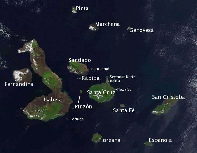
| Description | Satellite photo of the Galapagos islands overlayed with the Spanish names of the visible main islands. | ||||||||||
| Source | Based on the public domain NASA satellite photo Image:Galapagos-satellite-2002.jpg. Island names on labels are from the Wikipedia article w:en:Galápagos Islands and placed to the best of the author's knowledge. | ||||||||||
| Author | labeled by Storpilot | ||||||||||
| Permission ( Reusing this file) |
|
||||||||||
| Other versions |
 |

Licensing
| I, the copyright holder of this work, release this work into the
public domain. This applies worldwide. In some countries this may not be legally possible; if so: I grant anyone the right to use this work for any purpose, without any conditions, unless such conditions are required by law. |
File history
Click on a date/time to view the file as it appeared at that time.
| Date/Time | Thumbnail | Dimensions | User | Comment | |
|---|---|---|---|---|---|
| current | 15:57, 19 January 2006 |
| 674 × 525 (48 KB) | Storpilot | Description: Satellite photo of the Galapagos islands overlayed with the Spanish names of the visible main islands. Source: Based on the public domain NASA satellite photo Image:Galapagos-EO.jpg. Island names on labels are from the Wikipedia article |
File usage
The following pages on the English Wikipedia use this file (pages on other projects are not listed):
Global file usage
The following other wikis use this file:
- Usage on ar.wikipedia.org
- Usage on ban.wikipedia.org
- Usage on ba.wikipedia.org
- Usage on bg.wikipedia.org
- Usage on bs.wikipedia.org
- Usage on ca.wikipedia.org
- Usage on ceb.wikipedia.org
- Usage on cy.wikipedia.org
- Usage on da.wikipedia.org
- Usage on el.wikipedia.org
- Usage on en.wikiversity.org
- Usage on en.wiktionary.org
- Usage on es.wikipedia.org
- Usage on et.wikipedia.org
- Usage on eu.wikipedia.org
- Usage on fa.wikipedia.org
- Usage on fi.wikipedia.org
View more global usage of this file.
Metadata
No higher resolution available.
Galapagos-satellite-esislandnames.jpg (674 × 525 pixels, file size: 48 KB, MIME type: image/jpeg)
| This is a file from the
Wikimedia Commons. Information from its
description page there is shown below. Commons is a freely licensed media file repository. You can help. |
Summary
| Description | Satellite photo of the Galapagos islands overlayed with the Spanish names of the visible main islands. | ||||||||||
| Source | Based on the public domain NASA satellite photo Image:Galapagos-satellite-2002.jpg. Island names on labels are from the Wikipedia article w:en:Galápagos Islands and placed to the best of the author's knowledge. | ||||||||||
| Author | labeled by Storpilot | ||||||||||
| Permission ( Reusing this file) |
|
||||||||||
| Other versions |
|
Licensing
| I, the copyright holder of this work, release this work into the
public domain. This applies worldwide. In some countries this may not be legally possible; if so: I grant anyone the right to use this work for any purpose, without any conditions, unless such conditions are required by law. |
File history
Click on a date/time to view the file as it appeared at that time.
| Date/Time | Thumbnail | Dimensions | User | Comment | |
|---|---|---|---|---|---|
| current | 15:57, 19 January 2006 |
| 674 × 525 (48 KB) | Storpilot | Description: Satellite photo of the Galapagos islands overlayed with the Spanish names of the visible main islands. Source: Based on the public domain NASA satellite photo Image:Galapagos-EO.jpg. Island names on labels are from the Wikipedia article |
File usage
The following pages on the English Wikipedia use this file (pages on other projects are not listed):
Global file usage
The following other wikis use this file:
- Usage on ar.wikipedia.org
- Usage on ban.wikipedia.org
- Usage on ba.wikipedia.org
- Usage on bg.wikipedia.org
- Usage on bs.wikipedia.org
- Usage on ca.wikipedia.org
- Usage on ceb.wikipedia.org
- Usage on cy.wikipedia.org
- Usage on da.wikipedia.org
- Usage on el.wikipedia.org
- Usage on en.wikiversity.org
- Usage on en.wiktionary.org
- Usage on es.wikipedia.org
- Usage on et.wikipedia.org
- Usage on eu.wikipedia.org
- Usage on fa.wikipedia.org
- Usage on fi.wikipedia.org
View more global usage of this file.