Photos • Location


Size of this preview:
800 × 600 pixels. Other resolutions:
320 × 240 pixels |
640 × 480 pixels |
1,024 × 768 pixels |
1,280 × 960 pixels |
2,560 × 1,920 pixels.
Original file (2,560 × 1,920 pixels, file size: 818 KB, MIME type: image/jpeg)
| This is a file from the
Wikimedia Commons. Information from its
description page there is shown below. Commons is a freely licensed media file repository. You can help. |
|
This is an image of a place or building that is listed on the
National Register of Historic Places in the
United States of America. Its reference number is
66000106. |
| Description |
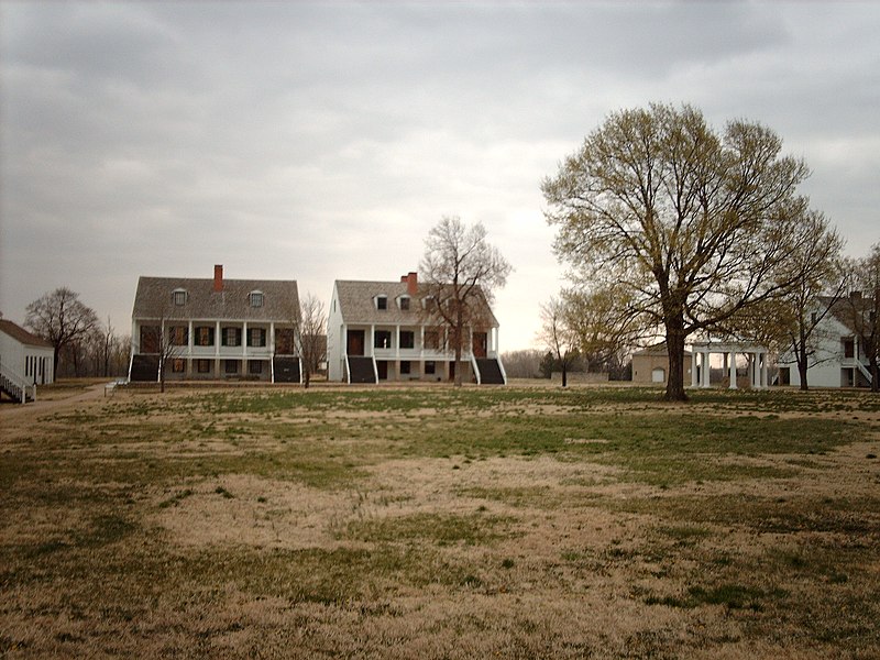
English:
Fort Scott National Historic Site. I took this myself. |
| Date | 19 April 2006 (original upload date) |
| Source | Transferred from en.wikipedia to Commons. |
| Author | The original uploader was Nationalparks at English Wikipedia. |
| Object location |
| View this and other nearby images on: OpenStreetMap |
|
|---|
Licensing
This file is licensed under the
Creative Commons
Attribution-Share Alike 2.5 Generic license.
- You are free:
- to share – to copy, distribute and transmit the work
- to remix – to adapt the work
- Under the following conditions:
- attribution – You must give appropriate credit, provide a link to the license, and indicate if changes were made. You may do so in any reasonable manner, but not in any way that suggests the licensor endorses you or your use.
- share alike – If you remix, transform, or build upon the material, you must distribute your contributions under the same or compatible license as the original.
Original upload log
The original description page was
here. All following user names refer to en.wikipedia.
- 2006-04-19 10:00 Nationalparks 2560×1920× (837617 bytes) [[Fort Scott National Historic Site]]. I took this myself.
File history
Click on a date/time to view the file as it appeared at that time.
| Date/Time | Thumbnail | Dimensions | User | Comment | |
|---|---|---|---|---|---|
| current | 14:58, 16 April 2009 |
| 2,560 × 1,920 (818 KB) | Urdangaray | {{Information |Description={{en| en:Fort Scott National Historic Site. I took this myself. en:Category:Images of Kansas}} |Source=Transferred from [http://en.wikipedia.org en.wikipedia] |Date={{Date|2006|04|19}} (original upload date) |Autho |
File usage
The following pages on the English Wikipedia use this file (pages on other projects are not listed):
- Fort Scott National Historic Site
- List of National Historic Landmarks in Kansas
- National Historic Site (United States)
- National Register of Historic Places listings in Bourbon County, Kansas
- National Register of Historic Places listings in Kansas
- User:Nationalparks
- Portal:American Civil War/Featured article
- Portal:Kansas/Selected article
- Portal:Kansas/Selected article/7
Global file usage
The following other wikis use this file:
- Usage on ceb.wikipedia.org
- Usage on de.wikipedia.org
- Usage on en.wikivoyage.org
- Usage on es.wikipedia.org
- Usage on fr.wikipedia.org
- Usage on la.wikipedia.org
- Usage on pt.wikipedia.org
- Usage on www.wikidata.org
Metadata
Size of this preview:
800 × 600 pixels. Other resolutions:
320 × 240 pixels |
640 × 480 pixels |
1,024 × 768 pixels |
1,280 × 960 pixels |
2,560 × 1,920 pixels.
Original file (2,560 × 1,920 pixels, file size: 818 KB, MIME type: image/jpeg)
| This is a file from the
Wikimedia Commons. Information from its
description page there is shown below. Commons is a freely licensed media file repository. You can help. |
|
This is an image of a place or building that is listed on the
National Register of Historic Places in the
United States of America. Its reference number is
66000106. |
| Description |
English:
Fort Scott National Historic Site. I took this myself. |
| Date | 19 April 2006 (original upload date) |
| Source | Transferred from en.wikipedia to Commons. |
| Author | The original uploader was Nationalparks at English Wikipedia. |
| Object location |
| View this and other nearby images on: OpenStreetMap |
|
|---|
Licensing
This file is licensed under the
Creative Commons
Attribution-Share Alike 2.5 Generic license.
- You are free:
- to share – to copy, distribute and transmit the work
- to remix – to adapt the work
- Under the following conditions:
- attribution – You must give appropriate credit, provide a link to the license, and indicate if changes were made. You may do so in any reasonable manner, but not in any way that suggests the licensor endorses you or your use.
- share alike – If you remix, transform, or build upon the material, you must distribute your contributions under the same or compatible license as the original.
Original upload log
The original description page was
here. All following user names refer to en.wikipedia.
- 2006-04-19 10:00 Nationalparks 2560×1920× (837617 bytes) [[Fort Scott National Historic Site]]. I took this myself.
File history
Click on a date/time to view the file as it appeared at that time.
| Date/Time | Thumbnail | Dimensions | User | Comment | |
|---|---|---|---|---|---|
| current | 14:58, 16 April 2009 |
| 2,560 × 1,920 (818 KB) | Urdangaray | {{Information |Description={{en| en:Fort Scott National Historic Site. I took this myself. en:Category:Images of Kansas}} |Source=Transferred from [http://en.wikipedia.org en.wikipedia] |Date={{Date|2006|04|19}} (original upload date) |Autho |
File usage
The following pages on the English Wikipedia use this file (pages on other projects are not listed):
- Fort Scott National Historic Site
- List of National Historic Landmarks in Kansas
- National Historic Site (United States)
- National Register of Historic Places listings in Bourbon County, Kansas
- National Register of Historic Places listings in Kansas
- User:Nationalparks
- Portal:American Civil War/Featured article
- Portal:Kansas/Selected article
- Portal:Kansas/Selected article/7
Global file usage
The following other wikis use this file:
- Usage on ceb.wikipedia.org
- Usage on de.wikipedia.org
- Usage on en.wikivoyage.org
- Usage on es.wikipedia.org
- Usage on fr.wikipedia.org
- Usage on la.wikipedia.org
- Usage on pt.wikipedia.org
- Usage on www.wikidata.org