Fort_Wayne-Huntington-Auburn_CSA.png (301 × 456 pixels, file size: 10 KB, MIME type: image/png)
| This is a file from the
Wikimedia Commons. Information from its
description page there is shown below. Commons is a freely licensed media file repository. You can help. |
| Description |
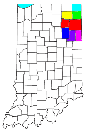
Locator map of the Fort Wayne-Huntington-Auburn Combined Statistical Area in the northeastern part of the U.S. state of Indiana. The seven components of the CSA are colored separately:
|
||
| Date | |||
| Source | Modified from this United States Census Bureau file, based on this Census definitions list. | ||
| Author | User:Nyttend | ||
| Permission ( Reusing this file) |
US Government work is public domain, and my work is
|
File history
Click on a date/time to view the file as it appeared at that time.
| Date/Time | Thumbnail | Dimensions | User | Comment | |
|---|---|---|---|---|---|
| current | 10:02, 12 August 2021 |
| 301 × 456 (10 KB) | Yassie | Definition as of March 6, 2020, on OMB 20-01 |
| 16:30, 30 July 2008 |
 | 301 × 456 (18 KB) | Nyttend | {{Information |Description=Locator map of the {{w|Fort Wayne-Huntington-Auburn, IN CSA|Fort Wayne-Huntington-Auburn}} {{w|Combined Statistical Area}} in the northeastern part of the {{w|U.S. state}} of {{w|Indiana}}. The five components of the CSA are co |
File usage
- Adams County, Indiana
- Albion, Indiana
- Allen County, Indiana
- Altona, Indiana
- Andrews, Indiana
- Ashley, Indiana
- Auburn, Indiana
- Avilla, Indiana
- Berne, Indiana
- Bluffton, Indiana
- Butler, Indiana
- Churubusco, Indiana
- Columbia City, Indiana
- Corunna, Indiana
- Cromwell, Indiana
- DeKalb County, Indiana
- Decatur, Indiana
- Fort Wayne, Indiana
- Fort Wayne metropolitan area, Indiana
- Garrett, Indiana
- Geneva, Indiana
- Grabill, Indiana
- Hamilton, Indiana
- Harlan, Indiana
- Hoagland, Indiana
- Huntertown, Indiana
- Huntington, Indiana
- Huntington County, Indiana
- Kendallville, Indiana
- Kimmell, Indiana
- Larwill, Indiana
- Leo-Cedarville, Indiana
- Ligonier, Indiana
- Markle, Indiana
- Monroe, Adams County, Indiana
- Monroeville, Indiana
- Mount Etna, Indiana
- New Haven, Indiana
- Noble County, Indiana
- Ossian, Indiana
- Poneto, Indiana
- Roanoke, Indiana
- Rome City, Indiana
- Saint Joe, Indiana
- South Whitley, Indiana
- Tri-Lakes, Indiana
- Uniondale, Indiana
- Vera Cruz, Indiana
- Warren, Indiana
- Waterloo, Indiana
- Wells County, Indiana
- Whitley County, Indiana
- Wolcottville, Indiana
- Woodburn, Indiana
- Zanesville, Indiana
- Template:Fort Wayne Metro
Global file usage
The following other wikis use this file:
- Usage on ja.wikipedia.org
- Usage on ro.wikipedia.org
- Usage on zh.wikipedia.org
Metadata
Fort_Wayne-Huntington-Auburn_CSA.png (301 × 456 pixels, file size: 10 KB, MIME type: image/png)
| This is a file from the
Wikimedia Commons. Information from its
description page there is shown below. Commons is a freely licensed media file repository. You can help. |
| Description |
Locator map of the Fort Wayne-Huntington-Auburn Combined Statistical Area in the northeastern part of the U.S. state of Indiana. The seven components of the CSA are colored separately:
|
||
| Date | |||
| Source | Modified from this United States Census Bureau file, based on this Census definitions list. | ||
| Author | User:Nyttend | ||
| Permission ( Reusing this file) |
US Government work is public domain, and my work is
|
File history
Click on a date/time to view the file as it appeared at that time.
| Date/Time | Thumbnail | Dimensions | User | Comment | |
|---|---|---|---|---|---|
| current | 10:02, 12 August 2021 |
| 301 × 456 (10 KB) | Yassie | Definition as of March 6, 2020, on OMB 20-01 |
| 16:30, 30 July 2008 |
| 301 × 456 (18 KB) | Nyttend | {{Information |Description=Locator map of the {{w|Fort Wayne-Huntington-Auburn, IN CSA|Fort Wayne-Huntington-Auburn}} {{w|Combined Statistical Area}} in the northeastern part of the {{w|U.S. state}} of {{w|Indiana}}. The five components of the CSA are co |
File usage
- Adams County, Indiana
- Albion, Indiana
- Allen County, Indiana
- Altona, Indiana
- Andrews, Indiana
- Ashley, Indiana
- Auburn, Indiana
- Avilla, Indiana
- Berne, Indiana
- Bluffton, Indiana
- Butler, Indiana
- Churubusco, Indiana
- Columbia City, Indiana
- Corunna, Indiana
- Cromwell, Indiana
- DeKalb County, Indiana
- Decatur, Indiana
- Fort Wayne, Indiana
- Fort Wayne metropolitan area, Indiana
- Garrett, Indiana
- Geneva, Indiana
- Grabill, Indiana
- Hamilton, Indiana
- Harlan, Indiana
- Hoagland, Indiana
- Huntertown, Indiana
- Huntington, Indiana
- Huntington County, Indiana
- Kendallville, Indiana
- Kimmell, Indiana
- Larwill, Indiana
- Leo-Cedarville, Indiana
- Ligonier, Indiana
- Markle, Indiana
- Monroe, Adams County, Indiana
- Monroeville, Indiana
- Mount Etna, Indiana
- New Haven, Indiana
- Noble County, Indiana
- Ossian, Indiana
- Poneto, Indiana
- Roanoke, Indiana
- Rome City, Indiana
- Saint Joe, Indiana
- South Whitley, Indiana
- Tri-Lakes, Indiana
- Uniondale, Indiana
- Vera Cruz, Indiana
- Warren, Indiana
- Waterloo, Indiana
- Wells County, Indiana
- Whitley County, Indiana
- Wolcottville, Indiana
- Woodburn, Indiana
- Zanesville, Indiana
- Template:Fort Wayne Metro
Global file usage
The following other wikis use this file:
- Usage on ja.wikipedia.org
- Usage on ro.wikipedia.org
- Usage on zh.wikipedia.org