Photos • Location


Size of this preview:
592 × 599 pixels. Other resolutions:
237 × 240 pixels |
474 × 480 pixels |
759 × 768 pixels |
1,012 × 1,024 pixels |
2,016 × 2,040 pixels.
Original file (2,016 × 2,040 pixels, file size: 728 KB, MIME type: image/jpeg)
| This is a file from the
Wikimedia Commons. Information from its
description page there is shown below. Commons is a freely licensed media file repository. You can help. |
Summary
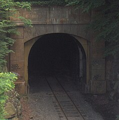
| Description | The Flat Rock Tunnel is an active railroad tunnel near Manayunk, Pennsylvania, USA. The tunnel was built by the Reading Railroad for its line along the Schuylkill River. |
| Date | |
| Source | Own work |
| Author | Davidt8 |
| Camera location |
| View this and other nearby images on: OpenStreetMap |
|
|---|
Licensing
| I, the copyright holder of this work, release this work into the
public domain. This applies worldwide. In some countries this may not be legally possible; if so: I grant anyone the right to use this work for any purpose, without any conditions, unless such conditions are required by law. |
File history
Click on a date/time to view the file as it appeared at that time.
| Date/Time | Thumbnail | Dimensions | User | Comment | |
|---|---|---|---|---|---|
| current | 15:54, 22 June 2010 |
| 2,016 × 2,040 (728 KB) | Davidt8 |
File usage
The following pages on the English Wikipedia use this file (pages on other projects are not listed):
Metadata
Size of this preview:
592 × 599 pixels. Other resolutions:
237 × 240 pixels |
474 × 480 pixels |
759 × 768 pixels |
1,012 × 1,024 pixels |
2,016 × 2,040 pixels.
Original file (2,016 × 2,040 pixels, file size: 728 KB, MIME type: image/jpeg)
| This is a file from the
Wikimedia Commons. Information from its
description page there is shown below. Commons is a freely licensed media file repository. You can help. |
Summary
| Description | The Flat Rock Tunnel is an active railroad tunnel near Manayunk, Pennsylvania, USA. The tunnel was built by the Reading Railroad for its line along the Schuylkill River. |
| Date | |
| Source | Own work |
| Author | Davidt8 |
| Camera location |
| View this and other nearby images on: OpenStreetMap |
|
|---|
Licensing
| I, the copyright holder of this work, release this work into the
public domain. This applies worldwide. In some countries this may not be legally possible; if so: I grant anyone the right to use this work for any purpose, without any conditions, unless such conditions are required by law. |
File history
Click on a date/time to view the file as it appeared at that time.
| Date/Time | Thumbnail | Dimensions | User | Comment | |
|---|---|---|---|---|---|
| current | 15:54, 22 June 2010 |
| 2,016 × 2,040 (728 KB) | Davidt8 |
File usage
The following pages on the English Wikipedia use this file (pages on other projects are not listed):