
Size of this PNG preview of this SVG file:
450 × 456 pixels. Other resolutions:
237 × 240 pixels |
474 × 480 pixels |
758 × 768 pixels |
1,011 × 1,024 pixels |
2,021 × 2,048 pixels.
Original file (SVG file, nominally 450 × 456 pixels, file size: 464 KB)
| This is a file from the
Wikimedia Commons. Information from its
description page there is shown below. Commons is a freely licensed media file repository. You can help. |
Summary


.svg)
.svg)
.svg)
.svg)
.svg)


.svg)
.svg)
.svg)


.png)
.png)


.svg)


.svg)

.svg)


.svg)
.svg)
.svg)
.svg)


.svg)
.png)


.svg)


.svg)
.svg)


.svg)


.svg)


.svg)
.svg)
.svg)
.svg)
.svg)
.svg)
.svg)
.svg)
_cropped.svg)
.svg)
.svg)
.svg)
.svg)
.svg)
.svg)
.svg)
.svg)
.svg)
.svg)
.svg)
.svg)
.svg)
.svg)
.svg)
.svg)
.svg)
.svg)
.svg)
.svg)
.svg)
.svg)
.svg)
.svg)
.svg)
.svg)
.svg)
.svg)
.svg)
.svg)
.svg)
.svg)
.svg)
.svg)
.svg)
.svg)
.svg)
.svg)
.svg)
.svg)
.svg)
.svg)
.svg)
.svg)
.svg)
Licensing
This file is licensed under the
Creative Commons
Attribution-Share Alike 3.0 Unported license.
- You are free:
- to share – to copy, distribute and transmit the work
- to remix – to adapt the work
- Under the following conditions:
- attribution – You must give appropriate credit, provide a link to the license, and indicate if changes were made. You may do so in any reasonable manner, but not in any way that suggests the licensor endorses you or your use.
- share alike – If you remix, transform, or build upon the material, you must distribute your contributions under the same or compatible license as the original.
Original upload log
This image is a derivative work of the following images:
-
File:Blank_map_of_Europe.svg licensed with Cc-by-sa-2.5
- 2011-09-19T22:57:58Z Alphathon 680x520 (603759 Bytes) Added North/Northern Cyprus
- 2011-08-23T10:26:48Z Heb 680x520 (604212 Bytes) Added [[:en:Bornholm]] (taken from [[:File:Denmark blank map.svg]])
- 2011-04-12T00:40:40Z Alphathon 680x520 (602549 Bytes) Upgraded Sicily based on "File:Freeworldmaps-sicily.jpg". Upgraded Malta based on "File:Map of Malta 2.png". Simplified Croatian borders.
- 2011-04-10T21:43:04Z Alphathon 680x520 (607359 Bytes) Upgraded Croatia, Bosnia & Herzegovina, Slovenia and surrounding countries based on data from "File:Kroatien - Politische Gliederung (Karte).png"
- 2011-04-10T20:05:09Z Alphathon 680x520 (568373 Bytes) Improved Serbia, Montenegro and surrounding countries using data from "File:Serbia Map.png". Fixed Serbia-Montenegro border. Added Kosovo (using dashed border, since it is not a universally recognised nation, and left the lan
- 2011-04-10T15:55:02Z Alphathon 680x520 (524980 Bytes) Tweaked Ukraine and surrounding countries based on data from "File:Up-map.png"
- 2011-04-10T04:02:09Z Alphathon 680x520 (511168 Bytes) Improved Greece, Albania, F.Y.R. Macedonia and Bulgaria based on "File:Greece topo.jpg"
- 2011-04-10T02:48:52Z Alphathon 680x520 (505569 Bytes) Tweaked Germany and surrounding countries based on info from "File:Germany_general_map.png"
- 2011-04-10T01:54:05Z Alphathon 680x520 (493733 Bytes) Converted all lakes back to separate layer. Added Finish lakes and tweaked Finland shape based on "File:Finland 1996 CIA map.jpg". Added Swiss lakes based on "File:Suisse cantons.svg". Tweaked Scotland and added Lochs.
- 2011-04-10T00:07:54Z Alphathon 680x520 (450120 Bytes) Improved England outline and added Isle of Wight based on "File:England Regions - Blank.svg". Improved Denmark based on "File:2 digit postcode danmark.png". Improved Sweden based on "File:Map of Sweden, CIA, 1996.jpg"
- 2011-04-08T15:53:07Z Alphathon 680x520 (438878 Bytes) Upgraded/fixed various parts of the map. Details: *Some minor fixes to Ireland and added some of the larger lakes based on [[:File:Ireland_trad_counties_named.svg]] *Pretty major fixes to Scotland (mainly the west coast and i
- 2008-09-17T09:50:25Z F7 680x520 (531491 Bytes)
- 2008-09-17T09:42:57Z F7 680x520 (2353 Bytes)
- 2008-05-26T19:04:07Z Collard 680x520 (531491 Bytes) uploading on behalf of [[User:Checkit]], direct complaints to him plox: 'Moved countries out of the "outlines" group, removed "outlines" style class, remove separate style information for Russia'
- 2008-04-30T01:38:52Z TimothyBourke 680x520 (531767 Bytes) Changed the country code of Serbia to RS per [http://en.wikipedia.org/wiki/Serbian_country_codes] and the file [http://www.iso.org/iso/iso3166_en_code_lists.txt].
- 2008-02-08T22:44:37Z CarolSpears 680x520 (531767 Bytes) validated
- 2007-07-10T11:47:59Z MrWeeble 680x520 (533112 Bytes) Updated to include British Crown Dependencies as seperate entities and regroup them as "British Islands", with some simplifications to the XML and CSS
- 2007-05-14T17:17:34Z Zirland 680x520 (540659 Bytes) serbia and montenegro
- 2007-03-30T20:40:49Z W!B: 680x520 (538830 Bytes) minor corr: update nl:Ijsselmeer, del fi:lakes (all small), add ru:lake Oneka (all ref maps.google), glued northern irland back to ie ;)
- 2007-02-05T18:44:32Z Maix 680x520 (538295 Bytes) cropped
- 2007-02-04T15:07:29Z Maix 680x520 (538310 Bytes) {{Information |Description=A blank Map of Europe in SVG format. Every country has an id which is its ISO-3116-1-ALPHA2 code in lower case for easy coloring. |Source=Image based on [[Image:Europe_countries.svg|]] by [[User:Ti
Uploaded with derivativeFX
File history
Click on a date/time to view the file as it appeared at that time.
| Date/Time | Thumbnail | Dimensions | User | Comment | |
|---|---|---|---|---|---|
| current | 18:29, 30 July 2012 |
| 450 × 456 (464 KB) | Alphathon | Prinicpalities |
| 00:14, 25 April 2012 |
 | 450 × 456 (462 KB) | Alphathon | Naming of objects | |
| 23:50, 24 April 2012 |
 | 450 × 456 (462 KB) | Alphathon | Added the Septinsular Republic. | |
| 01:53, 21 February 2012 |
 | 450 × 456 (459 KB) | Alphathon | +Semi-autonomous Ottoman states | |
| 21:10, 19 February 2012 |
 | 450 × 456 (437 KB) | Alphathon | Fixed Portugal | |
| 21:06, 19 February 2012 |
 | 450 × 456 (437 KB) | Alphathon | == {{int:filedesc}} == {{Information |Description=A map of the First French Empire in 1812. |Source={{Derived from|Blank_map_of_Europe.svg|display=50}} |Date=2012-02-19 21:04 (UTC) |Author=* File:Blank_map_of_Europe.svg: maix<sup>[[User |
File usage
The following pages on the English Wikipedia use this file (pages on other projects are not listed):
- Anconine Republic
- Batavian Republic
- Bolognese Republic
- Canton of Léman
- Cisalpine Republic
- Cispadane Republic
- Confederation of the Rhine
- Duchy of Berg
- Duchy of Warsaw
- First French Empire
- Free City of Danzig (Napoleonic)
- Gozo (1798–1800)
- Grand Duchy of Berg
- Grand Duchy of Frankfurt
- Grand Duchy of Würzburg
- Helvetic Republic
- Illyrian Provinces
- Irish Rebellion of 1798
- Italian Republic (Napoleonic)
- Kingdom of Etruria
- Kingdom of Holland
- Kingdom of Italy (Napoleonic)
- Kingdom of Naples (Napoleonic)
- Kingdom of Westphalia
- Ligurian Republic
- List of French client states
- Napoleonic Wars
- Parthenopean Republic
- Piedmontese Republic
- Principality of Aschaffenburg
- Principality of Erfurt
- Principality of Leyen
- Principality of Lucca and Piombino
- Principality of Pontecorvo
- Principality of Regensburg
- Principality of Salm
- Provisional Municipality of Venice
- Rauracian Republic
- Republic of Alba
- Republic of Bergamo
- Republic of Bouillon
- Republic of Brescia
- Republic of Crema
- Republic of Liège
- Republic of Lucca
- Republic of Mainz
- Roman Republic (1798–1799)
- Salm-Horstmar
- Salm-Reifferscheid-Dyck
- Sister republic
- Spain under Joseph Bonaparte
- Subalpine Republic
- Switzerland in the Napoleonic era
- Tellgovie
- Tiberina Republic
- Transpadane Republic
- Valais Republic
- Wetzlar
- User:Falcaorib
- User:InforManiac/Navbox04
- User:MarcusBritish/Sandbox/Military career of Napoleon Bonaparte
- User:Michael!/sandbox
- Template:Client states of the French Revolutionary and Napoleonic Wars
Global file usage
The following other wikis use this file:
- Usage on ar.wikipedia.org
- الحروب النابليونية
- جمهورية لكة
- مملكة نابولي
- مملكة بافاريا
- مملكة ساكسونيا
- مملكة فورتمبيرغ
- دوقية تسكانة الكبرى
- الجمهورية الألبية
- فتسلار
- دوقية بينيفينتو
- دوقية ماسا وكرارا
- اتحاد الراين
- مملكة إيطاليا النابوليونية
- جمهورية إيطاليا النابوليونية
- جمهورية شقيقة
- الجمهورية الرومانية (القرن 18)
- الجمهورية الليغورية
- دوقية بيرغ الكبرى
- مملكة فستفالن
- دوقية بادن الكبرى
- الجمهورية البارثينوبية
- دوقية هسن الكبرى
- إمارة ريغنسبورغ
- دوقية فورتسبورغ الكبرى
- دوقية فرانكفورت الكبرى
- إمارة زالم
- إمارة لاين
- الجمهورية الباتافية
- المملكة الهولندية
- جمهورية ألبا
- جمهورية لياج
- قالب:دول عميلة في الثورة الفرنسية وحروب نابليون
- مملكة إسبانيا النابليونية
- دوقية وارسو
- مدينة دانزيغ الحرة النابليونية
- سويسرا في العهد النابليوني
- الثورة الأيرلندية 1798
- مملكة إتروريا
- أقاليم إيليرية
- الجمهورية الهيلفيتية
- Usage on ast.wikipedia.org
- Usage on bg.wikipedia.org
- Usage on ca.wikipedia.org
View more global usage of this file.
Metadata
Size of this PNG preview of this SVG file:
450 × 456 pixels. Other resolutions:
237 × 240 pixels |
474 × 480 pixels |
758 × 768 pixels |
1,011 × 1,024 pixels |
2,021 × 2,048 pixels.
Original file (SVG file, nominally 450 × 456 pixels, file size: 464 KB)
| This is a file from the
Wikimedia Commons. Information from its
description page there is shown below. Commons is a freely licensed media file repository. You can help. |
Summary
| Description |
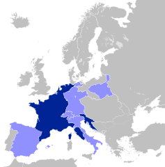
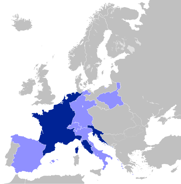
English: A map of the First French Empire and its dependencies/allies in 1812. Français : Carte du Premier Empire en 1812. |
||||||||||||||||||||||||||||||||||||||||||||||||||||||||||||||||||||||||||||||||||||||||||||||||||||||||||||||||||||||||||||||||||||||||||||||||||||||||||||||||||||||||||||||||||||||||||||||||||||||||||||||||||||||||||||||||||||||||||||||||||||||||||||||||||||||||||||||||||||||||||||||||||||||||||||||||||||||||||||||||||||||||||||||||||||||||||||||||||||||||||||||||||||||||||||||||||||||||||||||||||||||||||||||||||||||||||||||||||||||||||||||||||||||||||||||||||||||||||||||||||||||||||||||||||||||||||||||||||||||||||||||||||||||||||||||||||||||||||||||||||||||||||||||||||||||||||||||||||||||||||||
| Date | (UTC) | ||||||||||||||||||||||||||||||||||||||||||||||||||||||||||||||||||||||||||||||||||||||||||||||||||||||||||||||||||||||||||||||||||||||||||||||||||||||||||||||||||||||||||||||||||||||||||||||||||||||||||||||||||||||||||||||||||||||||||||||||||||||||||||||||||||||||||||||||||||||||||||||||||||||||||||||||||||||||||||||||||||||||||||||||||||||||||||||||||||||||||||||||||||||||||||||||||||||||||||||||||||||||||||||||||||||||||||||||||||||||||||||||||||||||||||||||||||||||||||||||||||||||||||||||||||||||||||||||||||||||||||||||||||||||||||||||||||||||||||||||||||||||||||||||||||||||||||||||||||||||||||
| Source |
This file was derived from:
Blank map of Europe (with disputed regions).svg:
|
||||||||||||||||||||||||||||||||||||||||||||||||||||||||||||||||||||||||||||||||||||||||||||||||||||||||||||||||||||||||||||||||||||||||||||||||||||||||||||||||||||||||||||||||||||||||||||||||||||||||||||||||||||||||||||||||||||||||||||||||||||||||||||||||||||||||||||||||||||||||||||||||||||||||||||||||||||||||||||||||||||||||||||||||||||||||||||||||||||||||||||||||||||||||||||||||||||||||||||||||||||||||||||||||||||||||||||||||||||||||||||||||||||||||||||||||||||||||||||||||||||||||||||||||||||||||||||||||||||||||||||||||||||||||||||||||||||||||||||||||||||||||||||||||||||||||||||||||||||||||||||
| Author |
|
||||||||||||||||||||||||||||||||||||||||||||||||||||||||||||||||||||||||||||||||||||||||||||||||||||||||||||||||||||||||||||||||||||||||||||||||||||||||||||||||||||||||||||||||||||||||||||||||||||||||||||||||||||||||||||||||||||||||||||||||||||||||||||||||||||||||||||||||||||||||||||||||||||||||||||||||||||||||||||||||||||||||||||||||||||||||||||||||||||||||||||||||||||||||||||||||||||||||||||||||||||||||||||||||||||||||||||||||||||||||||||||||||||||||||||||||||||||||||||||||||||||||||||||||||||||||||||||||||||||||||||||||||||||||||||||||||||||||||||||||||||||||||||||||||||||||||||||||||||||||||||
| Other versions |
English: This map is part of a series of historical political maps of Europe. All maps by
Alphathon and based upon
Blank map of Europe.svg unless otherwise stated.
Deutsch: Diese Karte ist Teil einer Serie historischer politischer Europakarten. Solange nicht anders angegeben, wurden alle Karten durch
Alphathon auf Basis von
Blank map of Europe.svg erstellt, sofern nicht anders angegeben.
Français : Cette carte fait partie d'une série de cartes historiques et politiques d'Europe. Toutes les cartes ont été créées par
Alphathon et basées sur
Blank map of Europe.svg sauf indication contraire.
Evolution of specific states Greece/Byzantine Empire
France
Germany/Holy Roman Empire
Austria
Hungary
Italy
Poland
Brandenburg, the Teutonic Order and Prussia
9th Century 814
11th Century 1000
1097
12th Century 1190
18th Century 1714
1789
1797
19th Century 1812
1815
1839
1890
20th Century 1914
1929-1938
October 1938 - March 1939
March - September 1939
1942
1956-1990
|
||||||||||||||||||||||||||||||||||||||||||||||||||||||||||||||||||||||||||||||||||||||||||||||||||||||||||||||||||||||||||||||||||||||||||||||||||||||||||||||||||||||||||||||||||||||||||||||||||||||||||||||||||||||||||||||||||||||||||||||||||||||||||||||||||||||||||||||||||||||||||||||||||||||||||||||||||||||||||||||||||||||||||||||||||||||||||||||||||||||||||||||||||||||||||||||||||||||||||||||||||||||||||||||||||||||||||||||||||||||||||||||||||||||||||||||||||||||||||||||||||||||||||||||||||||||||||||||||||||||||||||||||||||||||||||||||||||||||||||||||||||||||||||||||||||||||||||||||||||||||||||
Licensing
This file is licensed under the
Creative Commons
Attribution-Share Alike 3.0 Unported license.
- You are free:
- to share – to copy, distribute and transmit the work
- to remix – to adapt the work
- Under the following conditions:
- attribution – You must give appropriate credit, provide a link to the license, and indicate if changes were made. You may do so in any reasonable manner, but not in any way that suggests the licensor endorses you or your use.
- share alike – If you remix, transform, or build upon the material, you must distribute your contributions under the same or compatible license as the original.
Original upload log
This image is a derivative work of the following images:
-
File:Blank_map_of_Europe.svg licensed with Cc-by-sa-2.5
- 2011-09-19T22:57:58Z Alphathon 680x520 (603759 Bytes) Added North/Northern Cyprus
- 2011-08-23T10:26:48Z Heb 680x520 (604212 Bytes) Added [[:en:Bornholm]] (taken from [[:File:Denmark blank map.svg]])
- 2011-04-12T00:40:40Z Alphathon 680x520 (602549 Bytes) Upgraded Sicily based on "File:Freeworldmaps-sicily.jpg". Upgraded Malta based on "File:Map of Malta 2.png". Simplified Croatian borders.
- 2011-04-10T21:43:04Z Alphathon 680x520 (607359 Bytes) Upgraded Croatia, Bosnia & Herzegovina, Slovenia and surrounding countries based on data from "File:Kroatien - Politische Gliederung (Karte).png"
- 2011-04-10T20:05:09Z Alphathon 680x520 (568373 Bytes) Improved Serbia, Montenegro and surrounding countries using data from "File:Serbia Map.png". Fixed Serbia-Montenegro border. Added Kosovo (using dashed border, since it is not a universally recognised nation, and left the lan
- 2011-04-10T15:55:02Z Alphathon 680x520 (524980 Bytes) Tweaked Ukraine and surrounding countries based on data from "File:Up-map.png"
- 2011-04-10T04:02:09Z Alphathon 680x520 (511168 Bytes) Improved Greece, Albania, F.Y.R. Macedonia and Bulgaria based on "File:Greece topo.jpg"
- 2011-04-10T02:48:52Z Alphathon 680x520 (505569 Bytes) Tweaked Germany and surrounding countries based on info from "File:Germany_general_map.png"
- 2011-04-10T01:54:05Z Alphathon 680x520 (493733 Bytes) Converted all lakes back to separate layer. Added Finish lakes and tweaked Finland shape based on "File:Finland 1996 CIA map.jpg". Added Swiss lakes based on "File:Suisse cantons.svg". Tweaked Scotland and added Lochs.
- 2011-04-10T00:07:54Z Alphathon 680x520 (450120 Bytes) Improved England outline and added Isle of Wight based on "File:England Regions - Blank.svg". Improved Denmark based on "File:2 digit postcode danmark.png". Improved Sweden based on "File:Map of Sweden, CIA, 1996.jpg"
- 2011-04-08T15:53:07Z Alphathon 680x520 (438878 Bytes) Upgraded/fixed various parts of the map. Details: *Some minor fixes to Ireland and added some of the larger lakes based on [[:File:Ireland_trad_counties_named.svg]] *Pretty major fixes to Scotland (mainly the west coast and i
- 2008-09-17T09:50:25Z F7 680x520 (531491 Bytes)
- 2008-09-17T09:42:57Z F7 680x520 (2353 Bytes)
- 2008-05-26T19:04:07Z Collard 680x520 (531491 Bytes) uploading on behalf of [[User:Checkit]], direct complaints to him plox: 'Moved countries out of the "outlines" group, removed "outlines" style class, remove separate style information for Russia'
- 2008-04-30T01:38:52Z TimothyBourke 680x520 (531767 Bytes) Changed the country code of Serbia to RS per [http://en.wikipedia.org/wiki/Serbian_country_codes] and the file [http://www.iso.org/iso/iso3166_en_code_lists.txt].
- 2008-02-08T22:44:37Z CarolSpears 680x520 (531767 Bytes) validated
- 2007-07-10T11:47:59Z MrWeeble 680x520 (533112 Bytes) Updated to include British Crown Dependencies as seperate entities and regroup them as "British Islands", with some simplifications to the XML and CSS
- 2007-05-14T17:17:34Z Zirland 680x520 (540659 Bytes) serbia and montenegro
- 2007-03-30T20:40:49Z W!B: 680x520 (538830 Bytes) minor corr: update nl:Ijsselmeer, del fi:lakes (all small), add ru:lake Oneka (all ref maps.google), glued northern irland back to ie ;)
- 2007-02-05T18:44:32Z Maix 680x520 (538295 Bytes) cropped
- 2007-02-04T15:07:29Z Maix 680x520 (538310 Bytes) {{Information |Description=A blank Map of Europe in SVG format. Every country has an id which is its ISO-3116-1-ALPHA2 code in lower case for easy coloring. |Source=Image based on [[Image:Europe_countries.svg|]] by [[User:Ti
Uploaded with derivativeFX
File history
Click on a date/time to view the file as it appeared at that time.
| Date/Time | Thumbnail | Dimensions | User | Comment | |
|---|---|---|---|---|---|
| current | 18:29, 30 July 2012 |
| 450 × 456 (464 KB) | Alphathon | Prinicpalities |
| 00:14, 25 April 2012 |
| 450 × 456 (462 KB) | Alphathon | Naming of objects | |
| 23:50, 24 April 2012 |
| 450 × 456 (462 KB) | Alphathon | Added the Septinsular Republic. | |
| 01:53, 21 February 2012 |
| 450 × 456 (459 KB) | Alphathon | +Semi-autonomous Ottoman states | |
| 21:10, 19 February 2012 |
| 450 × 456 (437 KB) | Alphathon | Fixed Portugal | |
| 21:06, 19 February 2012 |
| 450 × 456 (437 KB) | Alphathon | == {{int:filedesc}} == {{Information |Description=A map of the First French Empire in 1812. |Source={{Derived from|Blank_map_of_Europe.svg|display=50}} |Date=2012-02-19 21:04 (UTC) |Author=* File:Blank_map_of_Europe.svg: maix<sup>[[User |
File usage
The following pages on the English Wikipedia use this file (pages on other projects are not listed):
- Anconine Republic
- Batavian Republic
- Bolognese Republic
- Canton of Léman
- Cisalpine Republic
- Cispadane Republic
- Confederation of the Rhine
- Duchy of Berg
- Duchy of Warsaw
- First French Empire
- Free City of Danzig (Napoleonic)
- Gozo (1798–1800)
- Grand Duchy of Berg
- Grand Duchy of Frankfurt
- Grand Duchy of Würzburg
- Helvetic Republic
- Illyrian Provinces
- Irish Rebellion of 1798
- Italian Republic (Napoleonic)
- Kingdom of Etruria
- Kingdom of Holland
- Kingdom of Italy (Napoleonic)
- Kingdom of Naples (Napoleonic)
- Kingdom of Westphalia
- Ligurian Republic
- List of French client states
- Napoleonic Wars
- Parthenopean Republic
- Piedmontese Republic
- Principality of Aschaffenburg
- Principality of Erfurt
- Principality of Leyen
- Principality of Lucca and Piombino
- Principality of Pontecorvo
- Principality of Regensburg
- Principality of Salm
- Provisional Municipality of Venice
- Rauracian Republic
- Republic of Alba
- Republic of Bergamo
- Republic of Bouillon
- Republic of Brescia
- Republic of Crema
- Republic of Liège
- Republic of Lucca
- Republic of Mainz
- Roman Republic (1798–1799)
- Salm-Horstmar
- Salm-Reifferscheid-Dyck
- Sister republic
- Spain under Joseph Bonaparte
- Subalpine Republic
- Switzerland in the Napoleonic era
- Tellgovie
- Tiberina Republic
- Transpadane Republic
- Valais Republic
- Wetzlar
- User:Falcaorib
- User:InforManiac/Navbox04
- User:MarcusBritish/Sandbox/Military career of Napoleon Bonaparte
- User:Michael!/sandbox
- Template:Client states of the French Revolutionary and Napoleonic Wars
Global file usage
The following other wikis use this file:
- Usage on ar.wikipedia.org
- الحروب النابليونية
- جمهورية لكة
- مملكة نابولي
- مملكة بافاريا
- مملكة ساكسونيا
- مملكة فورتمبيرغ
- دوقية تسكانة الكبرى
- الجمهورية الألبية
- فتسلار
- دوقية بينيفينتو
- دوقية ماسا وكرارا
- اتحاد الراين
- مملكة إيطاليا النابوليونية
- جمهورية إيطاليا النابوليونية
- جمهورية شقيقة
- الجمهورية الرومانية (القرن 18)
- الجمهورية الليغورية
- دوقية بيرغ الكبرى
- مملكة فستفالن
- دوقية بادن الكبرى
- الجمهورية البارثينوبية
- دوقية هسن الكبرى
- إمارة ريغنسبورغ
- دوقية فورتسبورغ الكبرى
- دوقية فرانكفورت الكبرى
- إمارة زالم
- إمارة لاين
- الجمهورية الباتافية
- المملكة الهولندية
- جمهورية ألبا
- جمهورية لياج
- قالب:دول عميلة في الثورة الفرنسية وحروب نابليون
- مملكة إسبانيا النابليونية
- دوقية وارسو
- مدينة دانزيغ الحرة النابليونية
- سويسرا في العهد النابليوني
- الثورة الأيرلندية 1798
- مملكة إتروريا
- أقاليم إيليرية
- الجمهورية الهيلفيتية
- Usage on ast.wikipedia.org
- Usage on bg.wikipedia.org
- Usage on ca.wikipedia.org
View more global usage of this file.