
Size of this PNG preview of this SVG file:
800 × 423 pixels. Other resolutions:
320 × 169 pixels |
640 × 339 pixels |
1,024 × 542 pixels |
1,280 × 677 pixels |
2,560 × 1,354 pixels |
1,565 × 828 pixels.
Original file (SVG file, nominally 1,565 × 828 pixels, file size: 69 KB)
| This is a file from the
Wikimedia Commons. Information from its
description page there is shown below. Commons is a freely licensed media file repository. You can help. |
Summary
| Description |
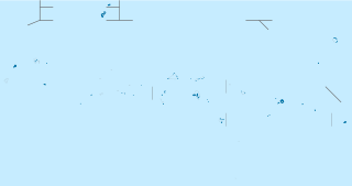
Deutsch: Positionskarte der
Föderierten Staaten von Mikronesien
Quadratische Plattkarte. Geographische Begrenzung der Karte:
English: Location map of the
Federated States of Micronesia
Equirectangular projection. Geographic limits of the map:
|
| Date | |
| Source |
own work, using
|
| Author | NordNordWest |

|
This map has been made or improved in the German
Kartenwerkstatt (Map Lab). You can
propose maps to improve as well.
|
Licensing
I, the copyright holder of this work, hereby publish it under the following licenses:

|
Permission is granted to copy, distribute and/or modify this document under the terms of the GNU Free Documentation License, Version 1.2 or any later version published by the Free Software Foundation; with no Invariant Sections, no Front-Cover Texts, and no Back-Cover Texts. A copy of the license is included in the section entitled GNU Free Documentation License. |
This file is licensed under the
Creative Commons
Attribution 3.0 Unported license.
- You are free:
- to share – to copy, distribute and transmit the work
- to remix – to adapt the work
- Under the following conditions:
- attribution – You must give appropriate credit, provide a link to the license, and indicate if changes were made. You may do so in any reasonable manner, but not in any way that suggests the licensor endorses you or your use.
You may select the license of your choice.
File history
Click on a date/time to view the file as it appeared at that time.
| Date/Time | Thumbnail | Dimensions | User | Comment | |
|---|---|---|---|---|---|
| current | 18:10, 18 April 2009 |
| 1,565 × 828 (69 KB) | NordNordWest | corr |
| 18:03, 18 April 2009 |
 | 1,565 × 828 (69 KB) | NordNordWest | {{Information |Description= {{de|Positionskarte der Föderierten Staaten von Mikronesien}} Quadratische Plattkarte. Geographische Begrenzung der Karte: * N: 14.5° N * S: 0.5° N * W: 139.0° O * O: 163.5° O {{ |
File usage
The following pages on the English Wikipedia use this file (pages on other projects are not listed):
- Catholic Belltower
- Chief Agriculturist House
- Chuuk International Airport
- Dolohmwar
- Eauripik
- Falalop
- Fauba Archaeological Site
- Fayu Atoll
- Fono, Federated States of Micronesia
- German Cemetery
- Immaculate Heart of Mary Cathedral (Weno, Chuuk)
- Japanese Army Headquarters (Tonowas)
- Japanese Artillery Road and Pohndolap Area
- Japanese Elementary School for Ponapean Children
- Japanese Hydro-electric Power Plant
- Japanese Shrine (Pohnpei)
- Kosrae International Airport
- Lelu, Federated States of Micronesia
- Likinlulem
- List of World Heritage Sites in The Federated States of Micronesia
- Mount Nanlaud
- Namonuito Atoll
- Nan Madol
- Nomwin
- Pattiw
- Piagailoe
- Pikelot
- Pingelap
- Pohnpei International Airport
- Poluwat
- Pulap
- Pulusuk
- Rull Men's Meetinghouse
- Rumung
- Sapwuahfik
- Satawal
- Sokehs Mass Grave Site
- Sorol
- Spanish Fort (Yap)
- Spanish Wall
- Tol (island)
- Tonotan Guns and Caves
- Udot (island)
- Ulithi
- Ulithi Airport
- Utwe
- Walung, Federated States of Micronesia
- Weno
- Wiichen Men's Meetinghouse
- Woleai
- Xavier High School, Micronesia
- Yap International Airport
- User:Ty654/List of earthquakes from 1900-1949 exceeding magnitude 7+
- User:Ty654/List of earthquakes from 1930-1939 exceeding magnitude 6+
- User:Ty654/List of earthquakes from 1940-1949 exceeding magnitude 6+
- User:Ty654/List of earthquakes from 1950-1954 exceeding magnitude 6+
- User:Ty654/List of earthquakes from 1950-1999 exceeding magnitude 7+
- User:Ty654/List of earthquakes from 1955-1959 exceeding magnitude 6+
- User:Ty654/List of earthquakes from 1960-1964 exceeding magnitude 6+
- User:Ty654/List of earthquakes from 1965-1969 exceeding magnitude 6+
- User:Ty654/List of earthquakes from 1970-1974 exceeding magnitude 6+
- User:Ty654/List of earthquakes from 1975-1979 exceeding magnitude 6+
- User:Ty654/List of earthquakes from 1980-1984 exceeding magnitude 6+
- User:Ty654/List of earthquakes from 1985-1989 exceeding magnitude 6+
- User:Ty654/List of earthquakes from 1990-1994 exceeding magnitude 6+
- User:Ty654/List of earthquakes from 1995-1999 exceeding magnitude 6+
- User:Ty654/List of earthquakes from 2000-2004 exceeding magnitude 6+
- User:Ty654/List of earthquakes from 2005-2009 exceeding magnitude 6+
- User:Ty654/List of earthquakes from 2010-2014 exceeding magnitude 6+
- User:Ty654/List of earthquakes from 2015-2019 exceeding magnitude 6+
- Module:Location map/data/Federated States of Micronesia
- Module:Location map/data/Federated States of Micronesia/doc
Global file usage
The following other wikis use this file:
- Usage on af.wikipedia.org
- Usage on als.wikipedia.org
- Usage on an.wikipedia.org
- Usage on ar.wikipedia.org
- Usage on ast.wikipedia.org
- Yap
- Palikir
- Mar de Filipines
- Módulu:Mapa de llocalización/datos/Estaos Federaos de Micronesia
- Módulu:Mapa de llocalización/datos/Estaos Federaos de Micronesia/usu
- Aeropuertu Internacional de Chuuk
- Aeropuertu Internacional de Kosrae
- Aeropuertu Internacional de Pohnpei
- Aeropuertu Internacional de Yap
- Módulu:Mapa de llocalización/datos/Micronesia/usu
- Atolón Losap
- Ulithi
- Falalop
- Pulap
- Tamatam
- Usage on az.wikipedia.org
- Usage on be-tarask.wikipedia.org
- Usage on be.wikipedia.org
- Usage on bg.wikipedia.org
- Usage on bn.wikipedia.org
- Usage on bs.wikipedia.org
- Usage on ceb.wikipedia.org
View more global usage of this file.
Size of this PNG preview of this SVG file:
800 × 423 pixels. Other resolutions:
320 × 169 pixels |
640 × 339 pixels |
1,024 × 542 pixels |
1,280 × 677 pixels |
2,560 × 1,354 pixels |
1,565 × 828 pixels.
Original file (SVG file, nominally 1,565 × 828 pixels, file size: 69 KB)
| This is a file from the
Wikimedia Commons. Information from its
description page there is shown below. Commons is a freely licensed media file repository. You can help. |
Summary
| Description |
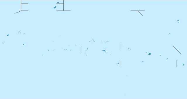
Deutsch: Positionskarte der
Föderierten Staaten von Mikronesien
Quadratische Plattkarte. Geographische Begrenzung der Karte:
English: Location map of the
Federated States of Micronesia
Equirectangular projection. Geographic limits of the map:
|
| Date | |
| Source |
own work, using
|
| Author | NordNordWest |
|
|
This map has been made or improved in the German
Kartenwerkstatt (Map Lab). You can
propose maps to improve as well.
|
Licensing
I, the copyright holder of this work, hereby publish it under the following licenses:
|
|
Permission is granted to copy, distribute and/or modify this document under the terms of the GNU Free Documentation License, Version 1.2 or any later version published by the Free Software Foundation; with no Invariant Sections, no Front-Cover Texts, and no Back-Cover Texts. A copy of the license is included in the section entitled GNU Free Documentation License. |
This file is licensed under the
Creative Commons
Attribution 3.0 Unported license.
- You are free:
- to share – to copy, distribute and transmit the work
- to remix – to adapt the work
- Under the following conditions:
- attribution – You must give appropriate credit, provide a link to the license, and indicate if changes were made. You may do so in any reasonable manner, but not in any way that suggests the licensor endorses you or your use.
You may select the license of your choice.
File history
Click on a date/time to view the file as it appeared at that time.
| Date/Time | Thumbnail | Dimensions | User | Comment | |
|---|---|---|---|---|---|
| current | 18:10, 18 April 2009 |
| 1,565 × 828 (69 KB) | NordNordWest | corr |
| 18:03, 18 April 2009 |
| 1,565 × 828 (69 KB) | NordNordWest | {{Information |Description= {{de|Positionskarte der Föderierten Staaten von Mikronesien}} Quadratische Plattkarte. Geographische Begrenzung der Karte: * N: 14.5° N * S: 0.5° N * W: 139.0° O * O: 163.5° O {{ |
File usage
The following pages on the English Wikipedia use this file (pages on other projects are not listed):
- Catholic Belltower
- Chief Agriculturist House
- Chuuk International Airport
- Dolohmwar
- Eauripik
- Falalop
- Fauba Archaeological Site
- Fayu Atoll
- Fono, Federated States of Micronesia
- German Cemetery
- Immaculate Heart of Mary Cathedral (Weno, Chuuk)
- Japanese Army Headquarters (Tonowas)
- Japanese Artillery Road and Pohndolap Area
- Japanese Elementary School for Ponapean Children
- Japanese Hydro-electric Power Plant
- Japanese Shrine (Pohnpei)
- Kosrae International Airport
- Lelu, Federated States of Micronesia
- Likinlulem
- List of World Heritage Sites in The Federated States of Micronesia
- Mount Nanlaud
- Namonuito Atoll
- Nan Madol
- Nomwin
- Pattiw
- Piagailoe
- Pikelot
- Pingelap
- Pohnpei International Airport
- Poluwat
- Pulap
- Pulusuk
- Rull Men's Meetinghouse
- Rumung
- Sapwuahfik
- Satawal
- Sokehs Mass Grave Site
- Sorol
- Spanish Fort (Yap)
- Spanish Wall
- Tol (island)
- Tonotan Guns and Caves
- Udot (island)
- Ulithi
- Ulithi Airport
- Utwe
- Walung, Federated States of Micronesia
- Weno
- Wiichen Men's Meetinghouse
- Woleai
- Xavier High School, Micronesia
- Yap International Airport
- User:Ty654/List of earthquakes from 1900-1949 exceeding magnitude 7+
- User:Ty654/List of earthquakes from 1930-1939 exceeding magnitude 6+
- User:Ty654/List of earthquakes from 1940-1949 exceeding magnitude 6+
- User:Ty654/List of earthquakes from 1950-1954 exceeding magnitude 6+
- User:Ty654/List of earthquakes from 1950-1999 exceeding magnitude 7+
- User:Ty654/List of earthquakes from 1955-1959 exceeding magnitude 6+
- User:Ty654/List of earthquakes from 1960-1964 exceeding magnitude 6+
- User:Ty654/List of earthquakes from 1965-1969 exceeding magnitude 6+
- User:Ty654/List of earthquakes from 1970-1974 exceeding magnitude 6+
- User:Ty654/List of earthquakes from 1975-1979 exceeding magnitude 6+
- User:Ty654/List of earthquakes from 1980-1984 exceeding magnitude 6+
- User:Ty654/List of earthquakes from 1985-1989 exceeding magnitude 6+
- User:Ty654/List of earthquakes from 1990-1994 exceeding magnitude 6+
- User:Ty654/List of earthquakes from 1995-1999 exceeding magnitude 6+
- User:Ty654/List of earthquakes from 2000-2004 exceeding magnitude 6+
- User:Ty654/List of earthquakes from 2005-2009 exceeding magnitude 6+
- User:Ty654/List of earthquakes from 2010-2014 exceeding magnitude 6+
- User:Ty654/List of earthquakes from 2015-2019 exceeding magnitude 6+
- Module:Location map/data/Federated States of Micronesia
- Module:Location map/data/Federated States of Micronesia/doc
Global file usage
The following other wikis use this file:
- Usage on af.wikipedia.org
- Usage on als.wikipedia.org
- Usage on an.wikipedia.org
- Usage on ar.wikipedia.org
- Usage on ast.wikipedia.org
- Yap
- Palikir
- Mar de Filipines
- Módulu:Mapa de llocalización/datos/Estaos Federaos de Micronesia
- Módulu:Mapa de llocalización/datos/Estaos Federaos de Micronesia/usu
- Aeropuertu Internacional de Chuuk
- Aeropuertu Internacional de Kosrae
- Aeropuertu Internacional de Pohnpei
- Aeropuertu Internacional de Yap
- Módulu:Mapa de llocalización/datos/Micronesia/usu
- Atolón Losap
- Ulithi
- Falalop
- Pulap
- Tamatam
- Usage on az.wikipedia.org
- Usage on be-tarask.wikipedia.org
- Usage on be.wikipedia.org
- Usage on bg.wikipedia.org
- Usage on bn.wikipedia.org
- Usage on bs.wikipedia.org
- Usage on ceb.wikipedia.org
View more global usage of this file.