
No higher resolution available.
FRYugoMap2k.jpg (351 × 378 pixels, file size: 116 KB, MIME type: image/jpeg)
| This is a file from the
Wikimedia Commons. Information from its
description page there is shown below. Commons is a freely licensed media file repository. You can help. |
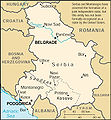
This is a map of The
Federal Republic of Yugoslavia (Serbia and Montenegro) [FRY (S&M)] from as the
2000 CIA World Factbook as mirrored by the
PCL.
-

-
 English 2000
 -
 English 2006
 -
 English 2006
 -
 English 2008
 -
 English 2008
 -
 español 2008
 -
 magyar 2008


This image is in the
public domain because it contains materials that originally came from the United States
Central Intelligence Agency's
World Factbook.
|
 |
File history
Click on a date/time to view the file as it appeared at that time.
| Date/Time | Thumbnail | Dimensions | User | Comment | |
|---|---|---|---|---|---|
| current | 05:18, 6 February 2007 |
| 351 × 378 (116 KB) | Hoshie | This is a map of The Federal Republic of Yugoslavia (Serbia and Montenegro) [FRY (S&M)] from as the [http://www.umsl.edu/services/govdocs/wofact2000/geos/sr.html 2000 CIA World Factbook] as mirrored by the [http://ww |
File usage
The following pages on the English Wikipedia use this file (pages on other projects are not listed):
Global file usage
The following other wikis use this file:
- Usage on es.wikipedia.org
- Usage on fa.wikipedia.org
- Usage on fr.wikipedia.org
- Usage on ja.wikipedia.org
- Usage on kk.wikipedia.org
- Usage on mr.wikipedia.org
- Usage on nl.wikipedia.org
- Usage on vi.wikipedia.org
- Usage on zh.wikipedia.org
Metadata
No higher resolution available.
FRYugoMap2k.jpg (351 × 378 pixels, file size: 116 KB, MIME type: image/jpeg)
| This is a file from the
Wikimedia Commons. Information from its
description page there is shown below. Commons is a freely licensed media file repository. You can help. |
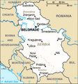
This is a map of The
Federal Republic of Yugoslavia (Serbia and Montenegro) [FRY (S&M)] from as the
2000 CIA World Factbook as mirrored by the
PCL.
-
-
English 2000
-
English 2006
-
English 2006
-
English 2008
-
English 2008
-
español 2008
-
magyar 2008
This image is in the
public domain because it contains materials that originally came from the United States
Central Intelligence Agency's
World Factbook.
|
|
File history
Click on a date/time to view the file as it appeared at that time.
| Date/Time | Thumbnail | Dimensions | User | Comment | |
|---|---|---|---|---|---|
| current | 05:18, 6 February 2007 |
| 351 × 378 (116 KB) | Hoshie | This is a map of The Federal Republic of Yugoslavia (Serbia and Montenegro) [FRY (S&M)] from as the [http://www.umsl.edu/services/govdocs/wofact2000/geos/sr.html 2000 CIA World Factbook] as mirrored by the [http://ww |
File usage
The following pages on the English Wikipedia use this file (pages on other projects are not listed):
Global file usage
The following other wikis use this file:
- Usage on es.wikipedia.org
- Usage on fa.wikipedia.org
- Usage on fr.wikipedia.org
- Usage on ja.wikipedia.org
- Usage on kk.wikipedia.org
- Usage on mr.wikipedia.org
- Usage on nl.wikipedia.org
- Usage on vi.wikipedia.org
- Usage on zh.wikipedia.org