Photos • Location


Size of this preview:
800 × 600 pixels. Other resolutions:
320 × 240 pixels |
640 × 480 pixels |
1,024 × 768 pixels |
1,280 × 960 pixels |
2,592 × 1,944 pixels.
Original file (2,592 × 1,944 pixels, file size: 2.33 MB, MIME type: image/jpeg)
| This is a file from the
Wikimedia Commons. Information from its
description page there is shown below. Commons is a freely licensed media file repository. You can help. |
Summary
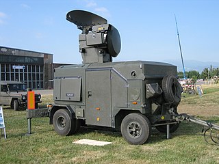
| Description | Oerlikon Contraves Skyguard. A towed anti-aircraft fire control system of the Austrian Air Force. |
| Date | |
| Source | Own work |
| Author | Markus Gattringer |
| Camera location |
| View this and other nearby images on: OpenStreetMap |
|
|---|
Licensing
I,
Markus Gattringer, the copyright holder of this work, hereby publishes it under the following licenses:

|
Permission is granted to copy, distribute and/or modify this document under the terms of the GNU Free Documentation License, Version 1.2 or any later version published by the Free Software Foundation; with no Invariant Sections, no Front-Cover Texts, and no Back-Cover Texts. A copy of the license is included in the section entitled GNU Free Documentation License. |
| This file is licensed under the Creative Commons Attribution-Share Alike 3.0 Unported license. | ||
| Attribution: I, Markus Gattringer | ||
| ||
| This licensing tag was added to this file as part of the GFDL licensing update. |
This file is licensed under the
Creative Commons Attribution-Share Alike
2.5 Generic,
2.0 Generic and
1.0 Generic license.
Attribution: I,
Markus Gattringer
- You are free:
- to share – to copy, distribute and transmit the work
- to remix – to adapt the work
- Under the following conditions:
- attribution – You must give appropriate credit, provide a link to the license, and indicate if changes were made. You may do so in any reasonable manner, but not in any way that suggests the licensor endorses you or your use.
- share alike – If you remix, transform, or build upon the material, you must distribute your contributions under the same or compatible license as the original.
You may select the license of your choice.
File history
Click on a date/time to view the file as it appeared at that time.
| Date/Time | Thumbnail | Dimensions | User | Comment | |
|---|---|---|---|---|---|
| current | 16:41, 13 July 2007 |
| 2,592 × 1,944 (2.33 MB) | Markus Gattringer | {{Information |Description=An Oerlikon Contraves Skyguard Radar of the Austrian Air Force |Source=self-made |Date=June 24, 2005 |Author= Markus Gattringer }} {{location dec|47.2023|14.7427}} |
File usage
The following pages on the English Wikipedia use this file (pages on other projects are not listed):
Global file usage
The following other wikis use this file:
- Usage on ar.wikipedia.org
- Usage on ca.wikipedia.org
- Usage on de.wikipedia.org
- Usage on es.wikipedia.org
- Usage on ru.wikipedia.org
- Usage on th.wikipedia.org
- Usage on tr.wikipedia.org
- Usage on uk.wikipedia.org
- Usage on ur.wikipedia.org
- Usage on www.wikidata.org
- Usage on zh.wikipedia.org
Metadata
Size of this preview:
800 × 600 pixels. Other resolutions:
320 × 240 pixels |
640 × 480 pixels |
1,024 × 768 pixels |
1,280 × 960 pixels |
2,592 × 1,944 pixels.
Original file (2,592 × 1,944 pixels, file size: 2.33 MB, MIME type: image/jpeg)
| This is a file from the
Wikimedia Commons. Information from its
description page there is shown below. Commons is a freely licensed media file repository. You can help. |
Summary
| Description | Oerlikon Contraves Skyguard. A towed anti-aircraft fire control system of the Austrian Air Force. |
| Date | |
| Source | Own work |
| Author | Markus Gattringer |
| Camera location |
| View this and other nearby images on: OpenStreetMap |
|
|---|
Licensing
I,
Markus Gattringer, the copyright holder of this work, hereby publishes it under the following licenses:
|
|
Permission is granted to copy, distribute and/or modify this document under the terms of the GNU Free Documentation License, Version 1.2 or any later version published by the Free Software Foundation; with no Invariant Sections, no Front-Cover Texts, and no Back-Cover Texts. A copy of the license is included in the section entitled GNU Free Documentation License. |
| This file is licensed under the Creative Commons Attribution-Share Alike 3.0 Unported license. | ||
| Attribution: I, Markus Gattringer | ||
| ||
| This licensing tag was added to this file as part of the GFDL licensing update. |
This file is licensed under the
Creative Commons Attribution-Share Alike
2.5 Generic,
2.0 Generic and
1.0 Generic license.
Attribution: I,
Markus Gattringer
- You are free:
- to share – to copy, distribute and transmit the work
- to remix – to adapt the work
- Under the following conditions:
- attribution – You must give appropriate credit, provide a link to the license, and indicate if changes were made. You may do so in any reasonable manner, but not in any way that suggests the licensor endorses you or your use.
- share alike – If you remix, transform, or build upon the material, you must distribute your contributions under the same or compatible license as the original.
You may select the license of your choice.
File history
Click on a date/time to view the file as it appeared at that time.
| Date/Time | Thumbnail | Dimensions | User | Comment | |
|---|---|---|---|---|---|
| current | 16:41, 13 July 2007 |
| 2,592 × 1,944 (2.33 MB) | Markus Gattringer | {{Information |Description=An Oerlikon Contraves Skyguard Radar of the Austrian Air Force |Source=self-made |Date=June 24, 2005 |Author= Markus Gattringer }} {{location dec|47.2023|14.7427}} |
File usage
The following pages on the English Wikipedia use this file (pages on other projects are not listed):
Global file usage
The following other wikis use this file:
- Usage on ar.wikipedia.org
- Usage on ca.wikipedia.org
- Usage on de.wikipedia.org
- Usage on es.wikipedia.org
- Usage on ru.wikipedia.org
- Usage on th.wikipedia.org
- Usage on tr.wikipedia.org
- Usage on uk.wikipedia.org
- Usage on ur.wikipedia.org
- Usage on www.wikidata.org
- Usage on zh.wikipedia.org