
Size of this PNG preview of this SVG file:
800 × 320 pixels. Other resolutions:
320 × 128 pixels |
640 × 256 pixels |
1,024 × 410 pixels |
1,280 × 512 pixels |
2,560 × 1,024 pixels |
1,000 × 400 pixels.
Original file (SVG file, nominally 1,000 × 400 pixels, file size: 127 KB)
| This is a file from the
Wikimedia Commons. Information from its
description page there is shown below. Commons is a freely licensed media file repository. You can help. |
Summary
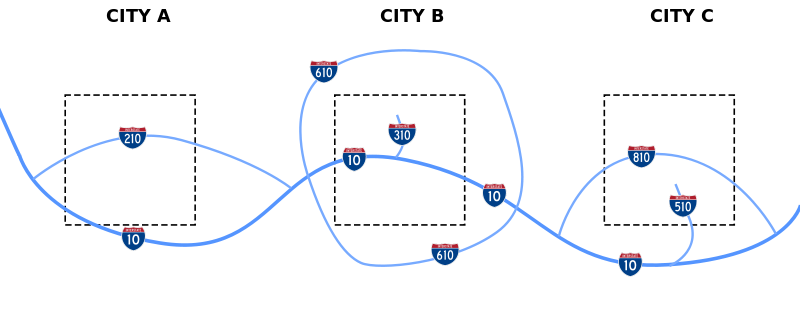
| Description | Diagram of how the FHWA assigns numbers to different types of interstate routes |
| Date | |
| Source | Own work |
| Author | Stratosphere |
| Permission ( Reusing this file) |
Public Domain |
Licensing
I, the copyright holder of this work, hereby publish it under the following license:
| This file is made available under the Creative Commons CC0 1.0 Universal Public Domain Dedication. | |
| The person who associated a work with this deed has dedicated the work to the
public domain by waiving all of their rights to the work worldwide under copyright law, including all related and neighboring rights, to the extent allowed by law. You can copy, modify, distribute and perform the work, even for commercial purposes, all without asking permission.
|
File history
Click on a date/time to view the file as it appeared at that time.
| Date/Time | Thumbnail | Dimensions | User | Comment | |
|---|---|---|---|---|---|
| current | 09:56, 18 February 2008 |
| 1,000 × 400 (127 KB) | Stratosphere | |
| 09:53, 18 February 2008 |
| 1,000 × 400 (21 KB) | Stratosphere | ||
| 09:47, 18 February 2008 |
| 1,000 × 400 (8 KB) | Stratosphere | ||
| 09:43, 18 February 2008 |
| 1,000 × 400 (7 KB) | Stratosphere | ||
| 09:41, 18 February 2008 |
| 1,000 × 400 (10 KB) | Stratosphere | {{Information |Description=Diagram of how the FHWA assigns numbers to different types of interstate routes |Source=self-made |Date=February 18, 2008 |Author= Stratosphere |Permission=Public Domain |other_versions= }} |
File usage
The following pages on the English Wikipedia use this file (pages on other projects are not listed):
Global file usage
The following other wikis use this file:
- Usage on es.wikipedia.org
- Usage on fr.wikipedia.org
- Usage on he.wikipedia.org
- Usage on it.wikipedia.org
- Usage on ru.wikipedia.org
- Usage on uk.wikipedia.org
- Usage on vi.wikipedia.org
- Usage on zh.wikipedia.org
Size of this PNG preview of this SVG file:
800 × 320 pixels. Other resolutions:
320 × 128 pixels |
640 × 256 pixels |
1,024 × 410 pixels |
1,280 × 512 pixels |
2,560 × 1,024 pixels |
1,000 × 400 pixels.
Original file (SVG file, nominally 1,000 × 400 pixels, file size: 127 KB)
| This is a file from the
Wikimedia Commons. Information from its
description page there is shown below. Commons is a freely licensed media file repository. You can help. |
Summary
| Description | Diagram of how the FHWA assigns numbers to different types of interstate routes |
| Date | |
| Source | Own work |
| Author | Stratosphere |
| Permission ( Reusing this file) |
Public Domain |
Licensing
I, the copyright holder of this work, hereby publish it under the following license:
| This file is made available under the Creative Commons CC0 1.0 Universal Public Domain Dedication. | |
| The person who associated a work with this deed has dedicated the work to the
public domain by waiving all of their rights to the work worldwide under copyright law, including all related and neighboring rights, to the extent allowed by law. You can copy, modify, distribute and perform the work, even for commercial purposes, all without asking permission.
|
File history
Click on a date/time to view the file as it appeared at that time.
| Date/Time | Thumbnail | Dimensions | User | Comment | |
|---|---|---|---|---|---|
| current | 09:56, 18 February 2008 |
| 1,000 × 400 (127 KB) | Stratosphere | |
| 09:53, 18 February 2008 |
| 1,000 × 400 (21 KB) | Stratosphere | ||
| 09:47, 18 February 2008 |
| 1,000 × 400 (8 KB) | Stratosphere | ||
| 09:43, 18 February 2008 |
| 1,000 × 400 (7 KB) | Stratosphere | ||
| 09:41, 18 February 2008 |
| 1,000 × 400 (10 KB) | Stratosphere | {{Information |Description=Diagram of how the FHWA assigns numbers to different types of interstate routes |Source=self-made |Date=February 18, 2008 |Author= Stratosphere |Permission=Public Domain |other_versions= }} |
File usage
The following pages on the English Wikipedia use this file (pages on other projects are not listed):
Global file usage
The following other wikis use this file:
- Usage on es.wikipedia.org
- Usage on fr.wikipedia.org
- Usage on he.wikipedia.org
- Usage on it.wikipedia.org
- Usage on ru.wikipedia.org
- Usage on uk.wikipedia.org
- Usage on vi.wikipedia.org
- Usage on zh.wikipedia.org