
Size of this PNG preview of this SVG file:
800 × 564 pixels. Other resolutions:
320 × 225 pixels |
640 × 451 pixels |
1,024 × 722 pixels |
1,280 × 902 pixels |
2,560 × 1,804 pixels |
3,535 × 2,491 pixels.
Original file (SVG file, nominally 3,535 × 2,491 pixels, file size: 710 KB)
| This is a file from the
Wikimedia Commons. Information from its
description page there is shown below. Commons is a freely licensed media file repository. You can help. |
Summary
| Description |
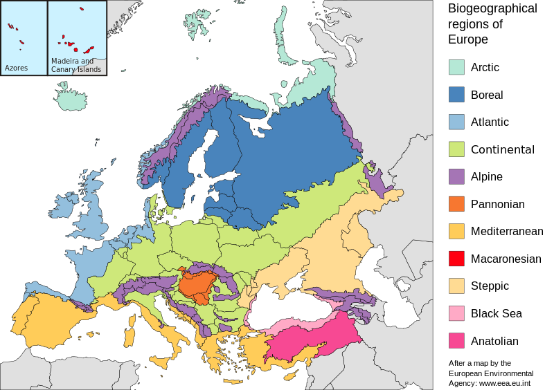
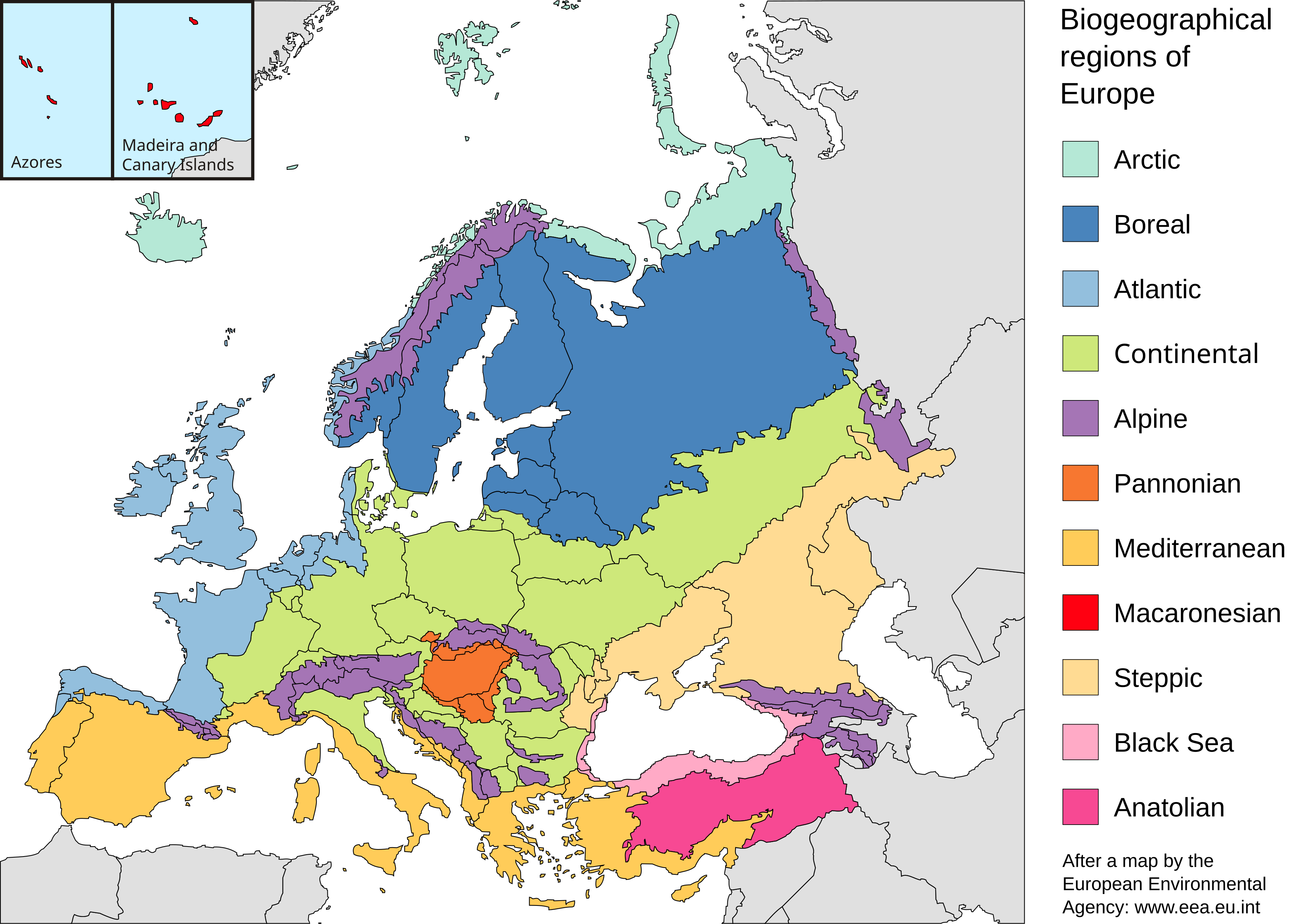
English: Map of the biogeographic regions of Europe, after EEA's map. Shows both country and biogeographical region boundaries. Legend in English. SVG format.
Español: Regiones biogeográficas de Europa.
Português: Regiões biogeográficas da Europa e regiões adjacentes.
한국어: Biogeographic regions. Biogeographic regions(Biogeographic regions.
Türkçe: Avrupa'nın Biyocoğrafik Bölgeleri (Türkiye'nin Asya kısmı da dahil).
Dansk: Pannonisk klima er her angivet med orange farve, der dækker dele af Slovakiet, Østrig, Serbien og Rumænien samt hele Ungarn.
Galego: Rexións bioxeográficas de Europa.
Norsk bokmål: Biogeografiske områder i Europa.
Norsk nynorsk: Biogeografiske område i Europa.
پښتو: Biogeographic regions of Europe.
Mirandés: Regiones biogeográficas de la Ouropa. |
| Date | |
| Source | Made with Inkscape from Image:Biogeographical Regions Europe - Map (intl).png by the European Environmental Agency |
| Author | Júlio Reis |
| Other versions |
Regions only:
Image:Europe biogeography regions.svg; blank map:
Image:Europe biogeography blank.svg  |
.png)
Licensing
This file is licensed under the
Creative Commons
Attribution-Share Alike 3.0 Unported license.
- You are free:
- to share – to copy, distribute and transmit the work
- to remix – to adapt the work
- Under the following conditions:
- attribution – You must give appropriate credit, provide a link to the license, and indicate if changes were made. You may do so in any reasonable manner, but not in any way that suggests the licensor endorses you or your use.
- share alike – If you remix, transform, or build upon the material, you must distribute your contributions under the same or compatible license as the original.
File history
Click on a date/time to view the file as it appeared at that time.
| Date/Time | Thumbnail | Dimensions | User | Comment | |
|---|---|---|---|---|---|
| current | 20:41, 19 July 2010 |
| 3,535 × 2,491 (710 KB) | Malus Catulus | Changed according graphic lab request: removed frame, hopefully fixed text, fixed some other stuff |
| 10:48, 23 May 2006 |
 | 3,600 × 2,610 (876 KB) | Tintazul | {{Tintazul| |Description=Map of the biogeographic regions of Europe, after EEA's map. Shows both country and biogeographical region boundaries. Legend in English. SVG format. |Date=20 May 2006 |Source=Made with Inkscape from [[:Image:Biogeographical Regi |
File usage
The following pages on the English Wikipedia use this file (pages on other projects are not listed):
- Alpine Biogeographic Region
- Anatolian Biogeographic Region
- Arctic Biogeographic Region
- Atlantic Biogeographic Region
- Biogeographic regions of Europe
- Biogeography
- Black Sea Biogeographic Region
- Boreal Biogeographic Region
- Continental Biogeographic Region
- Europe
- Fauna of Europe
- Geography of Armenia
- List of butterflies of Europe
- Macaronesian Biogeographic Region
- Mediterranean Biogeographic Region
- Pannonian Basin
- Pannonian Biogeographic Region
- Steppic Biogeographic Region
- User:Engram
- User:Kaarel/sandbox/Fauna of Europe
- User:Whytecypress/UserboxCaucasian
- User talk:BadYodels
- Template talk:Greek diaspora
- Portal:Maps
- Portal:Maps/Maps/Geographic
- Portal:Maps/Maps/Geographic/6
Global file usage
The following other wikis use this file:
- Usage on ar.wikipedia.org
- Usage on azb.wikipedia.org
- Usage on az.wikipedia.org
- Usage on beta.wikiversity.org
- Usage on bn.wikipedia.org
- Usage on bs.wikipedia.org
- Usage on cs.wikipedia.org
- Usage on da.wikipedia.org
- Usage on el.wikipedia.org
- Usage on en.wikiversity.org
- Usage on eo.wikipedia.org
- Usage on es.wikipedia.org
- Usage on fa.wikipedia.org
- Usage on ga.wikipedia.org
- Usage on gl.wikipedia.org
- Usage on hy.wikipedia.org
- Usage on ja.wikipedia.org
- Usage on ka.wikipedia.org
- Usage on ko.wikipedia.org
- Usage on mwl.wikipedia.org
- Usage on nl.wikipedia.org
- Usage on nn.wikipedia.org
- Usage on no.wikipedia.org
- Usage on pa.wikipedia.org
- Usage on pt.wikipedia.org
- Usage on ro.wikipedia.org
- Usage on ru.wikipedia.org
- Usage on sv.wikipedia.org
- Usage on sv.wikiversity.org
- Usage on tr.wikipedia.org
- Usage on uz.wikipedia.org
- Usage on vi.wikipedia.org
- Usage on www.wikidata.org
- Usage on xmf.wikipedia.org
- Usage on zh.wikipedia.org
Metadata
Size of this PNG preview of this SVG file:
800 × 564 pixels. Other resolutions:
320 × 225 pixels |
640 × 451 pixels |
1,024 × 722 pixels |
1,280 × 902 pixels |
2,560 × 1,804 pixels |
3,535 × 2,491 pixels.
Original file (SVG file, nominally 3,535 × 2,491 pixels, file size: 710 KB)
| This is a file from the
Wikimedia Commons. Information from its
description page there is shown below. Commons is a freely licensed media file repository. You can help. |
Summary
| Description |
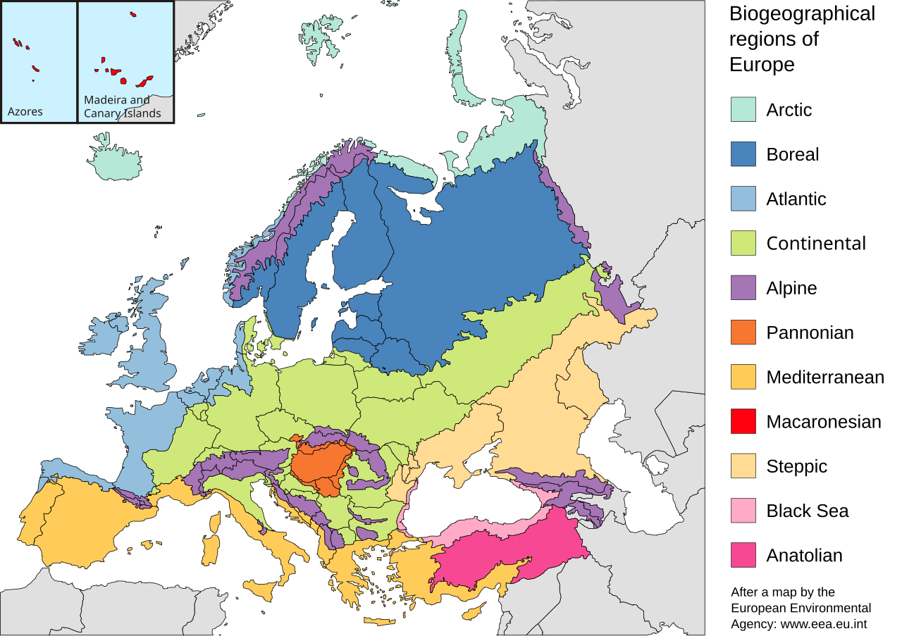
English: Map of the biogeographic regions of Europe, after EEA's map. Shows both country and biogeographical region boundaries. Legend in English. SVG format.
Español: Regiones biogeográficas de Europa.
Português: Regiões biogeográficas da Europa e regiões adjacentes.
한국어: Biogeographic regions. Biogeographic regions(Biogeographic regions.
Türkçe: Avrupa'nın Biyocoğrafik Bölgeleri (Türkiye'nin Asya kısmı da dahil).
Dansk: Pannonisk klima er her angivet med orange farve, der dækker dele af Slovakiet, Østrig, Serbien og Rumænien samt hele Ungarn.
Galego: Rexións bioxeográficas de Europa.
Norsk bokmål: Biogeografiske områder i Europa.
Norsk nynorsk: Biogeografiske område i Europa.
پښتو: Biogeographic regions of Europe.
Mirandés: Regiones biogeográficas de la Ouropa. |
| Date | |
| Source | Made with Inkscape from Image:Biogeographical Regions Europe - Map (intl).png by the European Environmental Agency |
| Author | Júlio Reis |
| Other versions |
Regions only:
Image:Europe biogeography regions.svg; blank map:
Image:Europe biogeography blank.svg |
Licensing
This file is licensed under the
Creative Commons
Attribution-Share Alike 3.0 Unported license.
- You are free:
- to share – to copy, distribute and transmit the work
- to remix – to adapt the work
- Under the following conditions:
- attribution – You must give appropriate credit, provide a link to the license, and indicate if changes were made. You may do so in any reasonable manner, but not in any way that suggests the licensor endorses you or your use.
- share alike – If you remix, transform, or build upon the material, you must distribute your contributions under the same or compatible license as the original.
File history
Click on a date/time to view the file as it appeared at that time.
| Date/Time | Thumbnail | Dimensions | User | Comment | |
|---|---|---|---|---|---|
| current | 20:41, 19 July 2010 |
| 3,535 × 2,491 (710 KB) | Malus Catulus | Changed according graphic lab request: removed frame, hopefully fixed text, fixed some other stuff |
| 10:48, 23 May 2006 |
| 3,600 × 2,610 (876 KB) | Tintazul | {{Tintazul| |Description=Map of the biogeographic regions of Europe, after EEA's map. Shows both country and biogeographical region boundaries. Legend in English. SVG format. |Date=20 May 2006 |Source=Made with Inkscape from [[:Image:Biogeographical Regi |
File usage
The following pages on the English Wikipedia use this file (pages on other projects are not listed):
- Alpine Biogeographic Region
- Anatolian Biogeographic Region
- Arctic Biogeographic Region
- Atlantic Biogeographic Region
- Biogeographic regions of Europe
- Biogeography
- Black Sea Biogeographic Region
- Boreal Biogeographic Region
- Continental Biogeographic Region
- Europe
- Fauna of Europe
- Geography of Armenia
- List of butterflies of Europe
- Macaronesian Biogeographic Region
- Mediterranean Biogeographic Region
- Pannonian Basin
- Pannonian Biogeographic Region
- Steppic Biogeographic Region
- User:Engram
- User:Kaarel/sandbox/Fauna of Europe
- User:Whytecypress/UserboxCaucasian
- User talk:BadYodels
- Template talk:Greek diaspora
- Portal:Maps
- Portal:Maps/Maps/Geographic
- Portal:Maps/Maps/Geographic/6
Global file usage
The following other wikis use this file:
- Usage on ar.wikipedia.org
- Usage on azb.wikipedia.org
- Usage on az.wikipedia.org
- Usage on beta.wikiversity.org
- Usage on bn.wikipedia.org
- Usage on bs.wikipedia.org
- Usage on cs.wikipedia.org
- Usage on da.wikipedia.org
- Usage on el.wikipedia.org
- Usage on en.wikiversity.org
- Usage on eo.wikipedia.org
- Usage on es.wikipedia.org
- Usage on fa.wikipedia.org
- Usage on ga.wikipedia.org
- Usage on gl.wikipedia.org
- Usage on hy.wikipedia.org
- Usage on ja.wikipedia.org
- Usage on ka.wikipedia.org
- Usage on ko.wikipedia.org
- Usage on mwl.wikipedia.org
- Usage on nl.wikipedia.org
- Usage on nn.wikipedia.org
- Usage on no.wikipedia.org
- Usage on pa.wikipedia.org
- Usage on pt.wikipedia.org
- Usage on ro.wikipedia.org
- Usage on ru.wikipedia.org
- Usage on sv.wikipedia.org
- Usage on sv.wikiversity.org
- Usage on tr.wikipedia.org
- Usage on uz.wikipedia.org
- Usage on vi.wikipedia.org
- Usage on www.wikidata.org
- Usage on xmf.wikipedia.org
- Usage on zh.wikipedia.org