
Original file (SVG file, nominally 700 × 512 pixels, file size: 384 KB)
| This is a file from the
Wikimedia Commons. Information from its
description page there is shown below. Commons is a freely licensed media file repository. You can help. |
Summary
| Description |
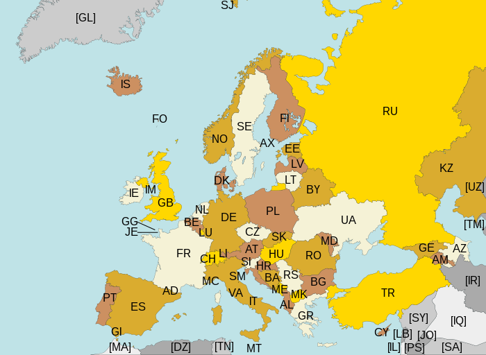
Map of Europe, with ISO 3166-1 pt · en country and territory codes. SVG format. Map legend in Portuguese and English, with name of sovereign state given in parenthesis, where applicable:
Non-European countries and territories featured in map:
|
| Date | |
| Source | Own work |
| Author | Júlio Reis |
| Other versions | Without country codes: Europe countries.svg · Only continent boundaries: Europe continents.svg · Country names in Italian: Europa-it-politica-names-big.svg · Including Kosovo: Europe ISO 3166-1 (with Kosovo).svg |
| SVG development |
.svg)
Licensing
- You are free:
- to share – to copy, distribute and transmit the work
- to remix – to adapt the work
- Under the following conditions:
- attribution – You must give appropriate credit, provide a link to the license, and indicate if changes were made. You may do so in any reasonable manner, but not in any way that suggests the licensor endorses you or your use.
- share alike – If you remix, transform, or build upon the material, you must distribute your contributions under the same or compatible license as the original.
File history
Click on a date/time to view the file as it appeared at that time.
| Date/Time | Thumbnail | Dimensions | User | Comment | |
|---|---|---|---|---|---|
| current | 22:43, 10 August 2015 |
| 700 × 512 (384 KB) | SiBr4 | Increasing contrast by slightly changing the map colors; splitting Serbia and Montenegro; cropping some more; plain SVG |
| 18:46, 10 April 2012 |
 | 800 × 512 (421 KB) | Ras67 | "cropped" | |
| 04:52, 13 March 2011 |
 | 800 × 520 (597 KB) | Chipmunkdavis | Fixing Turkey, adding Gibraltar | |
| 23:11, 22 August 2009 |
 | 800 × 520 (599 KB) | Tintazul | Croatia, Palestine | |
| 23:15, 4 November 2007 |
 | 800 × 520 (601 KB) | Lupo | Re-upload; trying to fix wrong MIME type | |
| 13:06, 14 August 2007 | No thumbnail | (601 KB) | Tintazul | replaced CS with RS+ME; replaced UK with GB; added AX, SJ, FO, IM, GG, JE | |
| 01:32, 11 January 2007 |
 | 800 × 520 (594 KB) | Angus | PT → HR | |
| 21:51, 7 June 2006 |
 | 800 × 520 (594 KB) | Tintazul | {{Tintazul| |Description=Map of Europe, with ISO 3166-1 <sup> pt · en</sup> country and territory codes. SVG format. Map legend in Portuguese and English, with name of sovereign state given in parenthesis, where appl |
File usage
Global file usage
The following other wikis use this file:
- Usage on ar.wikipedia.org
- Usage on arz.wikipedia.org
- Usage on bg.wikipedia.org
- Usage on bn.wikipedia.org
- Usage on cs.wikipedia.org
- Usage on eo.wikipedia.org
- Usage on es.wikipedia.org
- Usage on fi.wikipedia.org
- Usage on fo.wikipedia.org
- Usage on fr.wikipedia.org
- Usage on gl.wikipedia.org
- Usage on he.wikipedia.org
- Usage on id.wikipedia.org
- Usage on ilo.wikipedia.org
- Usage on ja.wikipedia.org
- Usage on ka.wikipedia.org
- Usage on lt.wikipedia.org
- Usage on mk.wikipedia.org
- Usage on nl.wikipedia.org
- Usage on no.wikipedia.org
- Usage on pt.wikipedia.org
- Usage on ru.wikipedia.org
- Usage on rw.wikipedia.org
- Usage on si.wikipedia.org
- Usage on sr.wikipedia.org
- Usage on su.wikipedia.org
- Usage on ta.wikipedia.org
- Usage on www.wikidata.org
- Usage on zh.wikipedia.org
Metadata
Original file (SVG file, nominally 700 × 512 pixels, file size: 384 KB)
| This is a file from the
Wikimedia Commons. Information from its
description page there is shown below. Commons is a freely licensed media file repository. You can help. |
Summary
| Description |
Map of Europe, with ISO 3166-1 pt · en country and territory codes. SVG format. Map legend in Portuguese and English, with name of sovereign state given in parenthesis, where applicable:
Non-European countries and territories featured in map:
|
| Date | |
| Source | Own work |
| Author | Júlio Reis |
| Other versions | Without country codes: Europe countries.svg · Only continent boundaries: Europe continents.svg · Country names in Italian: Europa-it-politica-names-big.svg · Including Kosovo: Europe ISO 3166-1 (with Kosovo).svg |
| SVG development |
Licensing
- You are free:
- to share – to copy, distribute and transmit the work
- to remix – to adapt the work
- Under the following conditions:
- attribution – You must give appropriate credit, provide a link to the license, and indicate if changes were made. You may do so in any reasonable manner, but not in any way that suggests the licensor endorses you or your use.
- share alike – If you remix, transform, or build upon the material, you must distribute your contributions under the same or compatible license as the original.
File history
Click on a date/time to view the file as it appeared at that time.
| Date/Time | Thumbnail | Dimensions | User | Comment | |
|---|---|---|---|---|---|
| current | 22:43, 10 August 2015 |
| 700 × 512 (384 KB) | SiBr4 | Increasing contrast by slightly changing the map colors; splitting Serbia and Montenegro; cropping some more; plain SVG |
| 18:46, 10 April 2012 |
| 800 × 512 (421 KB) | Ras67 | "cropped" | |
| 04:52, 13 March 2011 |
| 800 × 520 (597 KB) | Chipmunkdavis | Fixing Turkey, adding Gibraltar | |
| 23:11, 22 August 2009 |
| 800 × 520 (599 KB) | Tintazul | Croatia, Palestine | |
| 23:15, 4 November 2007 |
| 800 × 520 (601 KB) | Lupo | Re-upload; trying to fix wrong MIME type | |
| 13:06, 14 August 2007 | No thumbnail | (601 KB) | Tintazul | replaced CS with RS+ME; replaced UK with GB; added AX, SJ, FO, IM, GG, JE | |
| 01:32, 11 January 2007 |
| 800 × 520 (594 KB) | Angus | PT → HR | |
| 21:51, 7 June 2006 |
| 800 × 520 (594 KB) | Tintazul | {{Tintazul| |Description=Map of Europe, with ISO 3166-1 <sup> pt · en</sup> country and territory codes. SVG format. Map legend in Portuguese and English, with name of sovereign state given in parenthesis, where appl |
File usage
Global file usage
The following other wikis use this file:
- Usage on ar.wikipedia.org
- Usage on arz.wikipedia.org
- Usage on bg.wikipedia.org
- Usage on bn.wikipedia.org
- Usage on cs.wikipedia.org
- Usage on eo.wikipedia.org
- Usage on es.wikipedia.org
- Usage on fi.wikipedia.org
- Usage on fo.wikipedia.org
- Usage on fr.wikipedia.org
- Usage on gl.wikipedia.org
- Usage on he.wikipedia.org
- Usage on id.wikipedia.org
- Usage on ilo.wikipedia.org
- Usage on ja.wikipedia.org
- Usage on ka.wikipedia.org
- Usage on lt.wikipedia.org
- Usage on mk.wikipedia.org
- Usage on nl.wikipedia.org
- Usage on no.wikipedia.org
- Usage on pt.wikipedia.org
- Usage on ru.wikipedia.org
- Usage on rw.wikipedia.org
- Usage on si.wikipedia.org
- Usage on sr.wikipedia.org
- Usage on su.wikipedia.org
- Usage on ta.wikipedia.org
- Usage on www.wikidata.org
- Usage on zh.wikipedia.org