
Original file (1,444 × 1,200 pixels, file size: 1.25 MB, MIME type: image/jpeg)
| This is a file from the
Wikimedia Commons. Information from its
description page there is shown below. Commons is a freely licensed media file repository. You can help. |
Summary
| Description |
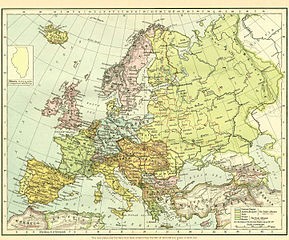
English: Map of Europe immediately after WWI. Pre-WWI borders are kept in color, while new states that emerged after WWI are presented in with red borders (see bottom of image). |
||||||||||||||||||||||
| Source | http://grossmanproject.net/Europe%20before%201918.htm | ||||||||||||||||||||||
| Author |
|
||||||||||||||||||||||
Similar map by the same author: http://en.wikipedia.org/wiki/File:Distribution_of_Races_on_the_Balkans_in_1923.jpg
Licensing
|
This work is in the public domain in its country of origin and other countries and areas where the copyright term is the author's life plus 70 years or fewer.
| |
| This file has been identified as being free of known restrictions under copyright law, including all related and neighboring rights. | |
and
This work is in the
public domain because it was published in the United States between 1929 and 1963, and although there may or may not have been a copyright notice, the
copyright was not renewed. For further explanation, see
Commons:Hirtle chart and
the copyright renewal logs. Note that it may still be copyrighted in jurisdictions that do not apply the
rule of the shorter term for US works (depending on the date of the author's death), such as Canada (70 years
p.m.a.), Mainland China (50 years p.m.a., not Hong Kong or Macao), Germany (70 years p.m.a.), Mexico (100 years p.m.a.), Switzerland (70 years p.m.a.), and other countries with individual treaties.
|
 |
File history
Click on a date/time to view the file as it appeared at that time.
| Date/Time | Thumbnail | Dimensions | User | Comment | |
|---|---|---|---|---|---|
| current | 19:36, 27 September 2010 |
| 1,444 × 1,200 (1.25 MB) | Kentronhayastan | Edited a red mark that isn't supposed to be there on the original scan (little square mark that was added by the source from which I found this file). |
| 10:55, 16 September 2010 |
 | 1,444 × 1,200 (862 KB) | Kentronhayastan | {{Information |Description={{en|1=Map of Europe immediately after WWI. Pre-WWI borders are kept in color, while new states that emerged after WWI are presented in with red borders (see bottom of image).}} |Source=Google search |Author=Unknown |Date= |Perm |
File usage
Global file usage
The following other wikis use this file:
- Usage on ar.wikipedia.org
- Usage on arz.wikipedia.org
- Usage on azb.wikipedia.org
- Usage on eo.wikipedia.org
- Usage on et.wikipedia.org
- Usage on fr.wikipedia.org
- Usage on hu.wikipedia.org
- Usage on hy.wikipedia.org
- Usage on it.wikipedia.org
- Usage on ro.wikipedia.org
Metadata
Original file (1,444 × 1,200 pixels, file size: 1.25 MB, MIME type: image/jpeg)
| This is a file from the
Wikimedia Commons. Information from its
description page there is shown below. Commons is a freely licensed media file repository. You can help. |
Summary
| Description |
English: Map of Europe immediately after WWI. Pre-WWI borders are kept in color, while new states that emerged after WWI are presented in with red borders (see bottom of image). |
||||||||||||||||||||||
| Source | http://grossmanproject.net/Europe%20before%201918.htm | ||||||||||||||||||||||
| Author |
|
||||||||||||||||||||||
Similar map by the same author: http://en.wikipedia.org/wiki/File:Distribution_of_Races_on_the_Balkans_in_1923.jpg
Licensing
|
This work is in the public domain in its country of origin and other countries and areas where the copyright term is the author's life plus 70 years or fewer.
| |
| This file has been identified as being free of known restrictions under copyright law, including all related and neighboring rights. | |
and
This work is in the
public domain because it was published in the United States between 1929 and 1963, and although there may or may not have been a copyright notice, the
copyright was not renewed. For further explanation, see
Commons:Hirtle chart and
the copyright renewal logs. Note that it may still be copyrighted in jurisdictions that do not apply the
rule of the shorter term for US works (depending on the date of the author's death), such as Canada (70 years
p.m.a.), Mainland China (50 years p.m.a., not Hong Kong or Macao), Germany (70 years p.m.a.), Mexico (100 years p.m.a.), Switzerland (70 years p.m.a.), and other countries with individual treaties.
|
|
File history
Click on a date/time to view the file as it appeared at that time.
| Date/Time | Thumbnail | Dimensions | User | Comment | |
|---|---|---|---|---|---|
| current | 19:36, 27 September 2010 |
| 1,444 × 1,200 (1.25 MB) | Kentronhayastan | Edited a red mark that isn't supposed to be there on the original scan (little square mark that was added by the source from which I found this file). |
| 10:55, 16 September 2010 |
| 1,444 × 1,200 (862 KB) | Kentronhayastan | {{Information |Description={{en|1=Map of Europe immediately after WWI. Pre-WWI borders are kept in color, while new states that emerged after WWI are presented in with red borders (see bottom of image).}} |Source=Google search |Author=Unknown |Date= |Perm |
File usage
Global file usage
The following other wikis use this file:
- Usage on ar.wikipedia.org
- Usage on arz.wikipedia.org
- Usage on azb.wikipedia.org
- Usage on eo.wikipedia.org
- Usage on et.wikipedia.org
- Usage on fr.wikipedia.org
- Usage on hu.wikipedia.org
- Usage on hy.wikipedia.org
- Usage on it.wikipedia.org
- Usage on ro.wikipedia.org