
Original file (4,000 × 3,000 pixels, file size: 2.82 MB, MIME type: image/jpeg)
| This is a file from the
Wikimedia Commons. Information from its
description page there is shown below. Commons is a freely licensed media file repository. You can help. |
.jpg)
Summary
| Description |
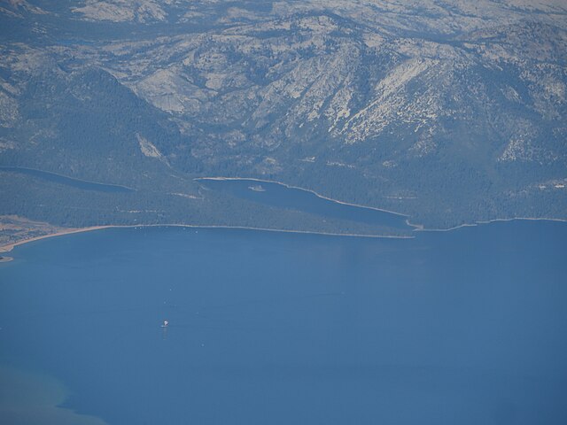
Emerald Bay State Park is a state park of California, USA, preserving Lake Tahoe's Emerald Bay, a National Natural Landmark. Park features include Eagle Falls and Vikingsholm, a 38-room mansion that is considered one of the finest examples of Scandinavian architecture in the United States. The architect was Leonard Palme, who was hired by his aunt Laura Knight to design and build Vikingsholm. The park contains the only island in Lake Tahoe, Fannette Island. The park is accessible by California State Route 89 near the southwest shore of the lake. Emerald Bay is one of Lake Tahoe's most photographed and popular locations. In 1969 Emerald Bay was recognized as a National Natural Landmark by the federal Department of the Interior. In 1994 California State Parks included the surrounding water of the bay as a part of the park, making Emerald Bay one of the first underwater parks of its type in the state, protecting the various wrecks and other items on the bay's bottom. The 1,533-acre (620 ha) park was established in 1953. It is located directly south of D. L. Bliss State Park. Summer temperatures at the park range from the low 40 °F (4 °C) at night to mid-70 °F (21 °C) during the day, and during the winter visitors will usually experience temperatures between 20 and 40 °F (−7 and 4 °C). During harsh winters the bay freezes over. The bay is about 1.7 miles (2.7 km) in length, and about two-thirds of a mile (1 km) wide at its widest point. en.wikipedia.org/wiki/Emerald_Bay_State_Park en.wikipedia.org/wiki/Wikipedia:Text_of_Creative_Commons_... |
| Date | |
| Source | Emerald Bay, Lake Tahoe, Nevada |
| Author | Ken Lund from Reno, Nevada, USA |
| Camera location |
| View this and other nearby images on: OpenStreetMap |
|
|---|
.jpg¶ms=038.987219_N_-119.642070_E_globe:Earth_type:camera_source:Flickr_&language=en)
Licensing
- You are free:
- to share – to copy, distribute and transmit the work
- to remix – to adapt the work
- Under the following conditions:
- attribution – You must give appropriate credit, provide a link to the license, and indicate if changes were made. You may do so in any reasonable manner, but not in any way that suggests the licensor endorses you or your use.
- share alike – If you remix, transform, or build upon the material, you must distribute your contributions under the same or compatible license as the original.
| This image was originally posted to Flickr by Ken Lund at https://flickr.com/photos/75683070@N00/21560966962. It was reviewed on 4 December 2015 by FlickreviewR and was confirmed to be licensed under the terms of the cc-by-sa-2.0. |
File history
Click on a date/time to view the file as it appeared at that time.
| Date/Time | Thumbnail | Dimensions | User | Comment | |
|---|---|---|---|---|---|
| current | 04:54, 4 December 2015 |
| 4,000 × 3,000 (2.82 MB) | INeverCry | Transferred from Flickr via Flickr2Commons |
File usage
Metadata
.jpg)
Original file (4,000 × 3,000 pixels, file size: 2.82 MB, MIME type: image/jpeg)
| This is a file from the
Wikimedia Commons. Information from its
description page there is shown below. Commons is a freely licensed media file repository. You can help. |
Summary
| Description |
Emerald Bay State Park is a state park of California, USA, preserving Lake Tahoe's Emerald Bay, a National Natural Landmark. Park features include Eagle Falls and Vikingsholm, a 38-room mansion that is considered one of the finest examples of Scandinavian architecture in the United States. The architect was Leonard Palme, who was hired by his aunt Laura Knight to design and build Vikingsholm. The park contains the only island in Lake Tahoe, Fannette Island. The park is accessible by California State Route 89 near the southwest shore of the lake. Emerald Bay is one of Lake Tahoe's most photographed and popular locations. In 1969 Emerald Bay was recognized as a National Natural Landmark by the federal Department of the Interior. In 1994 California State Parks included the surrounding water of the bay as a part of the park, making Emerald Bay one of the first underwater parks of its type in the state, protecting the various wrecks and other items on the bay's bottom. The 1,533-acre (620 ha) park was established in 1953. It is located directly south of D. L. Bliss State Park. Summer temperatures at the park range from the low 40 °F (4 °C) at night to mid-70 °F (21 °C) during the day, and during the winter visitors will usually experience temperatures between 20 and 40 °F (−7 and 4 °C). During harsh winters the bay freezes over. The bay is about 1.7 miles (2.7 km) in length, and about two-thirds of a mile (1 km) wide at its widest point. en.wikipedia.org/wiki/Emerald_Bay_State_Park en.wikipedia.org/wiki/Wikipedia:Text_of_Creative_Commons_... |
| Date | |
| Source | Emerald Bay, Lake Tahoe, Nevada |
| Author | Ken Lund from Reno, Nevada, USA |
| Camera location |
| View this and other nearby images on: OpenStreetMap |
|
|---|
Licensing
- You are free:
- to share – to copy, distribute and transmit the work
- to remix – to adapt the work
- Under the following conditions:
- attribution – You must give appropriate credit, provide a link to the license, and indicate if changes were made. You may do so in any reasonable manner, but not in any way that suggests the licensor endorses you or your use.
- share alike – If you remix, transform, or build upon the material, you must distribute your contributions under the same or compatible license as the original.
| This image was originally posted to Flickr by Ken Lund at https://flickr.com/photos/75683070@N00/21560966962. It was reviewed on 4 December 2015 by FlickreviewR and was confirmed to be licensed under the terms of the cc-by-sa-2.0. |
File history
Click on a date/time to view the file as it appeared at that time.
| Date/Time | Thumbnail | Dimensions | User | Comment | |
|---|---|---|---|---|---|
| current | 04:54, 4 December 2015 |
| 4,000 × 3,000 (2.82 MB) | INeverCry | Transferred from Flickr via Flickr2Commons |