
Size of this preview:
800 × 536 pixels. Other resolutions:
320 × 215 pixels |
640 × 429 pixels |
1,024 × 686 pixels |
1,180 × 791 pixels.
Original file (1,180 × 791 pixels, file size: 555 KB, MIME type: image/jpeg)
| This is a file from the
Wikimedia Commons. Information from its
description page there is shown below. Commons is a freely licensed media file repository. You can help. |
Summary
| Description |
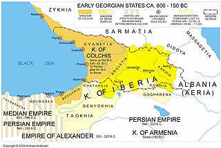
English: Early Georgian States of Colchis and Iberia. |
| Date | |
| Source | Own work |
| Author | Andrew Anderson |
| Permission ( Reusing this file) |
My own work |


Licensing
| I, the copyright holder of this work, release this work into the
public domain. This applies worldwide. In some countries this may not be legally possible; if so: I grant anyone the right to use this work for any purpose, without any conditions, unless such conditions are required by law. |
File history
Click on a date/time to view the file as it appeared at that time.
| Date/Time | Thumbnail | Dimensions | User | Comment | |
|---|---|---|---|---|---|
| current | 14:38, 15 May 2018 |
| 1,180 × 791 (555 KB) | Trecătorul răcit | Sarmatia, Massagetia without "h" |
| 22:25, 15 April 2010 |
 | 1,207 × 827 (135 KB) | AndersCaucasus | {{Information |Description={{en|1=Early Georgian States of Colchis and Iberia }} |Source=My own work based on research |Author=Andrew Anderson |Date=2005 |Permission=My own work |other_versions= }} |
File usage
The following pages on the English Wikipedia use this file (pages on other projects are not listed):
Global file usage
The following other wikis use this file:
- Usage on ar.wikipedia.org
- Usage on arz.wikipedia.org
- Usage on az.wikipedia.org
- Usage on bn.wikipedia.org
- Usage on ceb.wikipedia.org
- Usage on cy.wikipedia.org
- Usage on el.wikipedia.org
- Usage on es.wikipedia.org
- Usage on fa.wikipedia.org
- Usage on fr.wikipedia.org
- Usage on hr.wikipedia.org
- Usage on io.wikipedia.org
- Usage on it.wikipedia.org
- Usage on ja.wikipedia.org
- Usage on ka.wikipedia.org
- Usage on ko.wikipedia.org
- Usage on ru.wikipedia.org
- Usage on sh.wikipedia.org
- Usage on sr.wikipedia.org
- Usage on tr.wikipedia.org
- Usage on vi.wikipedia.org
- Usage on xmf.wikipedia.org
Metadata
Size of this preview:
800 × 536 pixels. Other resolutions:
320 × 215 pixels |
640 × 429 pixels |
1,024 × 686 pixels |
1,180 × 791 pixels.
Original file (1,180 × 791 pixels, file size: 555 KB, MIME type: image/jpeg)
| This is a file from the
Wikimedia Commons. Information from its
description page there is shown below. Commons is a freely licensed media file repository. You can help. |
Summary
| Description |
English: Early Georgian States of Colchis and Iberia. |
| Date | |
| Source | Own work |
| Author | Andrew Anderson |
| Permission ( Reusing this file) |
My own work |
Licensing
| I, the copyright holder of this work, release this work into the
public domain. This applies worldwide. In some countries this may not be legally possible; if so: I grant anyone the right to use this work for any purpose, without any conditions, unless such conditions are required by law. |
File history
Click on a date/time to view the file as it appeared at that time.
| Date/Time | Thumbnail | Dimensions | User | Comment | |
|---|---|---|---|---|---|
| current | 14:38, 15 May 2018 |
| 1,180 × 791 (555 KB) | Trecătorul răcit | Sarmatia, Massagetia without "h" |
| 22:25, 15 April 2010 |
| 1,207 × 827 (135 KB) | AndersCaucasus | {{Information |Description={{en|1=Early Georgian States of Colchis and Iberia }} |Source=My own work based on research |Author=Andrew Anderson |Date=2005 |Permission=My own work |other_versions= }} |
File usage
The following pages on the English Wikipedia use this file (pages on other projects are not listed):
Global file usage
The following other wikis use this file:
- Usage on ar.wikipedia.org
- Usage on arz.wikipedia.org
- Usage on az.wikipedia.org
- Usage on bn.wikipedia.org
- Usage on ceb.wikipedia.org
- Usage on cy.wikipedia.org
- Usage on el.wikipedia.org
- Usage on es.wikipedia.org
- Usage on fa.wikipedia.org
- Usage on fr.wikipedia.org
- Usage on hr.wikipedia.org
- Usage on io.wikipedia.org
- Usage on it.wikipedia.org
- Usage on ja.wikipedia.org
- Usage on ka.wikipedia.org
- Usage on ko.wikipedia.org
- Usage on ru.wikipedia.org
- Usage on sh.wikipedia.org
- Usage on sr.wikipedia.org
- Usage on tr.wikipedia.org
- Usage on vi.wikipedia.org
- Usage on xmf.wikipedia.org