
Original file (5,237 × 1,289 pixels, file size: 1.04 MB, MIME type: image/jpeg)
| This is a file from the
Wikimedia Commons. Information from its
description page there is shown below. Commons is a freely licensed media file repository. You can help. |
Summary
| Description |
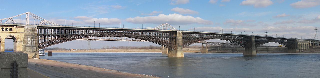
English: This is a panoramic image of the
Eads Bridge and Martin Luther King Bridge which span the
Mississippi River at
St. Louis, Missouri. This is a composite of four images taken with a Kodak P850 digital camera that were stitched with the
hugin panorama tool.
Français : Image panoramique montrant le pont Eads et le pont Martin Luther King franchissant le Mississippi à Saint Louis, dans le Missouri (Etats-Unis). Image obtenue en assemblant à l'aide de hugin quatre clichés pris avec un appareil numérique Kodak P850. |
| Date | |
| Source | Own work |
| Author | Kbh3rd |
Camera location 

View this and other nearby images on: OpenStreetMap 
Licensing
I, the copyright holder of this work, hereby publish it under the following licenses:

 This file is licensed under the Creative Commons Attribution-Share Alike 3.0 Unported license.
- You are free:
- to share – to copy, distribute and transmit the work
- to remix – to adapt the work
- Under the following conditions:
- attribution – You must give appropriate credit, provide a link to the license, and indicate if changes were made. You may do so in any reasonable manner, but not in any way that suggests the licensor endorses you or your use.
- share alike – If you remix, transform, or build upon the material, you must distribute your contributions under the same or compatible license as the original.
- You are free:

|
Permission is granted to copy, distribute and/or modify this document under the terms of the GNU Free Documentation License, Version 1.2 or any later version published by the Free Software Foundation; with no Invariant Sections, no Front-Cover Texts, and no Back-Cover Texts. A copy of the license is included in the section entitled GNU Free Documentation License. |

|
This image has been assessed under the valued image criteria and is considered the most valued image on Commons within the scope: Eads Bridge, St. Louis. You can see its nomination here. |
File history
Click on a date/time to view the file as it appeared at that time.
| Date/Time | Thumbnail | Dimensions | User | Comment | |
|---|---|---|---|---|---|
| current | 04:33, 21 January 2009 |
| 5,237 × 1,289 (1.04 MB) | Kbh3rd | |
| 01:31, 20 January 2009 |
| 4,868 × 1,474 (1.21 MB) | Kbh3rd | {{Information |Description={{en|1=This is a panoramic image of the Eads Bridge which spans the Mississippi River at St. Louis, Missouri. This is a composite of four images taken wi |
File usage
Global file usage
The following other wikis use this file:
- Usage on ar.wikipedia.org
- Usage on arz.wikipedia.org
- Usage on de.wikipedia.org
- Usage on en.wikivoyage.org
- Usage on es.wikipedia.org
- Usage on fa.wikipedia.org
- Usage on fr.wikipedia.org
- Usage on it.wikivoyage.org
- Usage on ja.wikipedia.org
- Usage on sv.wikipedia.org
- Usage on uz.wikipedia.org
- Usage on www.wikidata.org
Original file (5,237 × 1,289 pixels, file size: 1.04 MB, MIME type: image/jpeg)
| This is a file from the
Wikimedia Commons. Information from its
description page there is shown below. Commons is a freely licensed media file repository. You can help. |
Summary
| Description |
English: This is a panoramic image of the
Eads Bridge and Martin Luther King Bridge which span the
Mississippi River at
St. Louis, Missouri. This is a composite of four images taken with a Kodak P850 digital camera that were stitched with the
hugin panorama tool.
Français : Image panoramique montrant le pont Eads et le pont Martin Luther King franchissant le Mississippi à Saint Louis, dans le Missouri (Etats-Unis). Image obtenue en assemblant à l'aide de hugin quatre clichés pris avec un appareil numérique Kodak P850. |
| Date | |
| Source | Own work |
| Author | Kbh3rd |
Camera location
View this and other nearby images on: OpenStreetMap Licensing
I, the copyright holder of this work, hereby publish it under the following licenses:
This file is licensed under the Creative Commons Attribution-Share Alike 3.0 Unported license.- You are free:
- to share – to copy, distribute and transmit the work
- to remix – to adapt the work
- Under the following conditions:
- attribution – You must give appropriate credit, provide a link to the license, and indicate if changes were made. You may do so in any reasonable manner, but not in any way that suggests the licensor endorses you or your use.
- share alike – If you remix, transform, or build upon the material, you must distribute your contributions under the same or compatible license as the original.
- You are free:
|
|
Permission is granted to copy, distribute and/or modify this document under the terms of the GNU Free Documentation License, Version 1.2 or any later version published by the Free Software Foundation; with no Invariant Sections, no Front-Cover Texts, and no Back-Cover Texts. A copy of the license is included in the section entitled GNU Free Documentation License. |
|
|
This image has been assessed under the valued image criteria and is considered the most valued image on Commons within the scope: Eads Bridge, St. Louis. You can see its nomination here. |
File history
Click on a date/time to view the file as it appeared at that time.
| Date/Time | Thumbnail | Dimensions | User | Comment | |
|---|---|---|---|---|---|
| current | 04:33, 21 January 2009 |
| 5,237 × 1,289 (1.04 MB) | Kbh3rd | |
| 01:31, 20 January 2009 |
| 4,868 × 1,474 (1.21 MB) | Kbh3rd | {{Information |Description={{en|1=This is a panoramic image of the Eads Bridge which spans the Mississippi River at St. Louis, Missouri. This is a composite of four images taken wi |
File usage
Global file usage
The following other wikis use this file:
- Usage on ar.wikipedia.org
- Usage on arz.wikipedia.org
- Usage on de.wikipedia.org
- Usage on en.wikivoyage.org
- Usage on es.wikipedia.org
- Usage on fa.wikipedia.org
- Usage on fr.wikipedia.org
- Usage on it.wikivoyage.org
- Usage on ja.wikipedia.org
- Usage on sv.wikipedia.org
- Usage on uz.wikipedia.org
- Usage on www.wikidata.org