No higher resolution available.
ECO_CDC_Map.png (485 × 424 pixels, file size: 19 KB, MIME type: image/png)
| This is a file from the
Wikimedia Commons. Information from its
description page there is shown below. Commons is a freely licensed media file repository. You can help. |

|
This map image could be re-created using
vector graphics as an
SVG file. This has several advantages; see
Commons:Media for cleanup for more information. If an SVG form of this image is available, please upload it and afterwards replace this template with
{{
vector version available|new image name}}
.
It is recommended to name the SVG file “ECO CDC Map.svg”—then the template Vector version available (or Vva) does not need the new image name parameter. |
Summary
| Description |
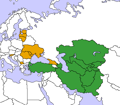
English: Map of the
Economic Cooperation Organization and the
Community of Democratic Choice. Created by me,
User:Aris Katsaris by modifying
Image:Turkestan.png.
Aris Katsaris 06:48, 15 March 2006 (UTC) |
| Source | No machine-readable source provided. Own work assumed (based on copyright claims). |
| Author | No machine-readable author provided. Aris Katsaris assumed (based on copyright claims). |
Licensing
I, the copyright holder of this work, hereby publish it under the following licenses:

|
Permission is granted to copy, distribute and/or modify this document under the terms of the GNU Free Documentation License, Version 1.2 or any later version published by the Free Software Foundation; with no Invariant Sections, no Front-Cover Texts, and no Back-Cover Texts. A copy of the license is included in the section entitled GNU Free Documentation License. |
| This file is licensed under the Creative Commons Attribution-Share Alike 3.0 Unported license. | ||
| ||
| This licensing tag was added to this file as part of the GFDL licensing update. |
This file is licensed under the
Creative Commons
Attribution 2.5 Generic license.
- You are free:
- to share – to copy, distribute and transmit the work
- to remix – to adapt the work
- Under the following conditions:
- attribution – You must give appropriate credit, provide a link to the license, and indicate if changes were made. You may do so in any reasonable manner, but not in any way that suggests the licensor endorses you or your use.
You may select the license of your choice.
File history
Click on a date/time to view the file as it appeared at that time.
| Date/Time | Thumbnail | Dimensions | User | Comment | |
|---|---|---|---|---|---|
| current | 10:31, 22 June 2018 |
| 485 × 424 (19 KB) | Koreanovsky | Fix, the map itself is very bad - working on a better version |
| 05:56, 10 April 2006 |
 | 485 × 424 (18 KB) | Aris Katsaris | Change in land/sea borders | |
| 06:48, 15 March 2006 |
 | 485 × 424 (20 KB) | Aris Katsaris | Map of the Economic Cooperation Organization and the Community of Democratic Choice. Created by me, User:Aris Katsaris by modifying Image:Turkestan.png. ~~~~ Category:Supranational maps |
File usage
The following pages on the English Wikipedia use this file (pages on other projects are not listed):
Global file usage
The following other wikis use this file:
- Usage on fa.wikipedia.org
- Usage on hr.wikipedia.org
- Usage on ja.wikipedia.org
- Usage on sh.wikipedia.org
- Usage on sr.wikipedia.org
- Usage on zh.wikipedia.org
Metadata
No higher resolution available.
ECO_CDC_Map.png (485 × 424 pixels, file size: 19 KB, MIME type: image/png)
| This is a file from the
Wikimedia Commons. Information from its
description page there is shown below. Commons is a freely licensed media file repository. You can help. |
|
|
This map image could be re-created using
vector graphics as an
SVG file. This has several advantages; see
Commons:Media for cleanup for more information. If an SVG form of this image is available, please upload it and afterwards replace this template with
{{
vector version available|new image name}}
.
It is recommended to name the SVG file “ECO CDC Map.svg”—then the template Vector version available (or Vva) does not need the new image name parameter. |
Summary
| Description |
English: Map of the
Economic Cooperation Organization and the
Community of Democratic Choice. Created by me,
User:Aris Katsaris by modifying
Image:Turkestan.png.
Aris Katsaris 06:48, 15 March 2006 (UTC) |
| Source | No machine-readable source provided. Own work assumed (based on copyright claims). |
| Author | No machine-readable author provided. Aris Katsaris assumed (based on copyright claims). |
Licensing
I, the copyright holder of this work, hereby publish it under the following licenses:
|
|
Permission is granted to copy, distribute and/or modify this document under the terms of the GNU Free Documentation License, Version 1.2 or any later version published by the Free Software Foundation; with no Invariant Sections, no Front-Cover Texts, and no Back-Cover Texts. A copy of the license is included in the section entitled GNU Free Documentation License. |
| This file is licensed under the Creative Commons Attribution-Share Alike 3.0 Unported license. | ||
| ||
| This licensing tag was added to this file as part of the GFDL licensing update. |
This file is licensed under the
Creative Commons
Attribution 2.5 Generic license.
- You are free:
- to share – to copy, distribute and transmit the work
- to remix – to adapt the work
- Under the following conditions:
- attribution – You must give appropriate credit, provide a link to the license, and indicate if changes were made. You may do so in any reasonable manner, but not in any way that suggests the licensor endorses you or your use.
You may select the license of your choice.
File history
Click on a date/time to view the file as it appeared at that time.
| Date/Time | Thumbnail | Dimensions | User | Comment | |
|---|---|---|---|---|---|
| current | 10:31, 22 June 2018 |
| 485 × 424 (19 KB) | Koreanovsky | Fix, the map itself is very bad - working on a better version |
| 05:56, 10 April 2006 |
| 485 × 424 (18 KB) | Aris Katsaris | Change in land/sea borders | |
| 06:48, 15 March 2006 |
| 485 × 424 (20 KB) | Aris Katsaris | Map of the Economic Cooperation Organization and the Community of Democratic Choice. Created by me, User:Aris Katsaris by modifying Image:Turkestan.png. ~~~~ Category:Supranational maps |
File usage
The following pages on the English Wikipedia use this file (pages on other projects are not listed):
Global file usage
The following other wikis use this file:
- Usage on fa.wikipedia.org
- Usage on hr.wikipedia.org
- Usage on ja.wikipedia.org
- Usage on sh.wikipedia.org
- Usage on sr.wikipedia.org
- Usage on zh.wikipedia.org