No higher resolution available.
Drum-Heller-Channels.jpg (500 × 388 pixels, file size: 37 KB, MIME type: image/jpeg)
| This is a file from the
Wikimedia Commons. Information from its
description page there is shown below. Commons is a freely licensed media file repository. You can help. |
Summary
| Description |
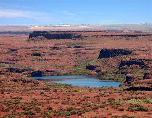
English: Drumheller Channels; East edge of the Royal Slope in the Columbia Valley south of the Pot Holes Reservoir by 10 miles; the lake I believe is Black Lake. |
| Date | 16 August 2004 (original upload date) |
| Source | Own work by the original uploader |
| Author | Woofles ( talk · contribs) |
| Permission ( Reusing this file) |
Released under the GNU Free Documentation License. |
Licensing
Woofles at
English Wikipedia, the copyright holder of this work, hereby publishes it under the following licenses:

|
Permission is granted to copy, distribute and/or modify this document under the terms of the GNU Free Documentation License, Version 1.2 or any later version published by the Free Software Foundation; with no Invariant Sections, no Front-Cover Texts, and no Back-Cover Texts. A copy of the license is included in the section entitled GNU Free Documentation License. Subject to disclaimers. |
| This file is licensed under the Creative Commons Attribution-Share Alike 3.0 Unported license. Subject to disclaimers. | ||
| Attribution: Woofles at English Wikipedia | ||
| ||
| This licensing tag was added to this file as part of the GFDL licensing update. |
You may select the license of your choice.
Original upload log
Transferred from en.wikipedia to Commons by Hike395.
The original description page was
here. All following user names refer to en.wikipedia.
- 2004-08-16 20:30 Woofles 500×388×8 (38205 bytes) DrumHeller Channels
File history
Click on a date/time to view the file as it appeared at that time.
| Date/Time | Thumbnail | Dimensions | User | Comment | |
|---|---|---|---|---|---|
| current | 05:12, 23 April 2007 |
| 500 × 388 (37 KB) | Hike395 | {{Information |Description=Drumheller Channels; East edge of the Royal Slope in the Columbia Valley south of the Pot Holes Reservoir by 10 miles; the lake I believe is Black Lake. Taken by myself |Source=Originally from [http://en.wikipedia.org en.wikiped |
File usage
The following pages on the English Wikipedia use this file (pages on other projects are not listed):
Global file usage
The following other wikis use this file:
- Usage on arz.wikipedia.org
- Usage on az.wikipedia.org
- Usage on ca.wikipedia.org
- Usage on de.wikipedia.org
- Usage on eo.wikipedia.org
- Usage on es.wikipedia.org
- Usage on fr.wikipedia.org
- Usage on gd.wikipedia.org
- Usage on hy.wikipedia.org
- Usage on it.wikipedia.org
- Usage on ja.wikipedia.org
- Usage on nl.wikipedia.org
- Usage on pl.wikipedia.org
- Usage on pt.wikipedia.org
- Usage on ru.wikipedia.org
- Usage on uk.wikipedia.org
- Usage on vi.wikipedia.org
- Usage on www.wikidata.org
Metadata
No higher resolution available.
Drum-Heller-Channels.jpg (500 × 388 pixels, file size: 37 KB, MIME type: image/jpeg)
| This is a file from the
Wikimedia Commons. Information from its
description page there is shown below. Commons is a freely licensed media file repository. You can help. |
Summary
| Description |
English: Drumheller Channels; East edge of the Royal Slope in the Columbia Valley south of the Pot Holes Reservoir by 10 miles; the lake I believe is Black Lake. |
| Date | 16 August 2004 (original upload date) |
| Source | Own work by the original uploader |
| Author | Woofles ( talk · contribs) |
| Permission ( Reusing this file) |
Released under the GNU Free Documentation License. |
Licensing
Woofles at
English Wikipedia, the copyright holder of this work, hereby publishes it under the following licenses:
|
|
Permission is granted to copy, distribute and/or modify this document under the terms of the GNU Free Documentation License, Version 1.2 or any later version published by the Free Software Foundation; with no Invariant Sections, no Front-Cover Texts, and no Back-Cover Texts. A copy of the license is included in the section entitled GNU Free Documentation License. Subject to disclaimers. |
| This file is licensed under the Creative Commons Attribution-Share Alike 3.0 Unported license. Subject to disclaimers. | ||
| Attribution: Woofles at English Wikipedia | ||
| ||
| This licensing tag was added to this file as part of the GFDL licensing update. |
You may select the license of your choice.
Original upload log
Transferred from en.wikipedia to Commons by Hike395.
The original description page was
here. All following user names refer to en.wikipedia.
- 2004-08-16 20:30 Woofles 500×388×8 (38205 bytes) DrumHeller Channels
File history
Click on a date/time to view the file as it appeared at that time.
| Date/Time | Thumbnail | Dimensions | User | Comment | |
|---|---|---|---|---|---|
| current | 05:12, 23 April 2007 |
| 500 × 388 (37 KB) | Hike395 | {{Information |Description=Drumheller Channels; East edge of the Royal Slope in the Columbia Valley south of the Pot Holes Reservoir by 10 miles; the lake I believe is Black Lake. Taken by myself |Source=Originally from [http://en.wikipedia.org en.wikiped |
File usage
The following pages on the English Wikipedia use this file (pages on other projects are not listed):
Global file usage
The following other wikis use this file:
- Usage on arz.wikipedia.org
- Usage on az.wikipedia.org
- Usage on ca.wikipedia.org
- Usage on de.wikipedia.org
- Usage on eo.wikipedia.org
- Usage on es.wikipedia.org
- Usage on fr.wikipedia.org
- Usage on gd.wikipedia.org
- Usage on hy.wikipedia.org
- Usage on it.wikipedia.org
- Usage on ja.wikipedia.org
- Usage on nl.wikipedia.org
- Usage on pl.wikipedia.org
- Usage on pt.wikipedia.org
- Usage on ru.wikipedia.org
- Usage on uk.wikipedia.org
- Usage on vi.wikipedia.org
- Usage on www.wikidata.org