No higher resolution available.
Dervish_1900.png (233 × 253 pixels, file size: 40 KB, MIME type: image/png)
| This is a file from the
Wikimedia Commons. Information from its
description page there is shown below. Commons is a freely licensed media file repository. You can help. |
Summary
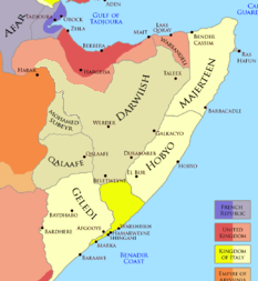
| Description |
English: The Ogaden region and the Dervish State and the Horn of Africa in 1900 After the Ogaden and Dervish attack upon the Area of Jigjiga The official Dervish borders were: Northwestern, was at Jidali per the excerpt "nearest dervish post was now at Jidali" (source: MOyse-Bartlett, The King's African Rifles page 421) western, was at Badwein per the excerpt "Badwein at the eastern extremity of the Ain Valley, and thence south-west to the southern border at a point where it is intersected by the 46th degree of longitude. It was our object to confine Dervish activities to their side of this line" (Source: Douglas Jardine, 1923, page 250) southern official boundary was at Damot/Do'mo per excerpt "cattle shall not be permitted to pass beyond the pasturage of the wells enumerated hereafter, they are the wells ... to Damot" (source: Douglas Jardine, 1923, page 158) |
| Date | |
| Source | https://www.pinterest.com/pin/589690144944704455/ |
| Author | Somaliyeed |

|
This image could be re-created using
vector graphics as an
SVG file. This has several advantages; see
Commons:Media for cleanup for more information. If an SVG form of this image is available, please upload it and afterwards replace this template with
{{
vector version available|new image name}}
.
It is recommended to name the SVG file “Dervish 1900.svg”—then the template Vector version available (or Vva) does not need the new image name parameter. |
Licensing
I, the copyright holder of this work, hereby publish it under the following license:
This file is licensed under the
Creative Commons
Attribution-Share Alike 4.0 International license.
- You are free:
- to share – to copy, distribute and transmit the work
- to remix – to adapt the work
- Under the following conditions:
- attribution – You must give appropriate credit, provide a link to the license, and indicate if changes were made. You may do so in any reasonable manner, but not in any way that suggests the licensor endorses you or your use.
- share alike – If you remix, transform, or build upon the material, you must distribute your contributions under the same or compatible license as the original.
File history
Click on a date/time to view the file as it appeared at that time.
| Date/Time | Thumbnail | Dimensions | User | Comment | |
|---|---|---|---|---|---|
| current | 05:37, 14 September 2023 |
| 233 × 253 (40 KB) | CXDS | Reverted to version as of 02:24, 4 November 2022 (UTC) |
| 12:47, 29 May 2023 |
 | 233 × 253 (48 KB) | Sgottharivuu | east | |
| 19:51, 28 May 2023 |
 | 233 × 253 (47 KB) | Sgottharivuu | Ogaden states | |
| 18:18, 28 May 2023 |
 | 233 × 253 (47 KB) | Sgottharivuu | There are no historical records that an annexation of Jigjiga took place. Hence corrected the map | |
| 02:24, 4 November 2022 |
 | 233 × 253 (40 KB) | Somaliyeed | Uploaded own work with UploadWizard |
File usage
The following pages on the English Wikipedia use this file (pages on other projects are not listed):
Global file usage
The following other wikis use this file:
- Usage on es.wikipedia.org
- Usage on tr.wikipedia.org
Metadata
No higher resolution available.
Dervish_1900.png (233 × 253 pixels, file size: 40 KB, MIME type: image/png)
| This is a file from the
Wikimedia Commons. Information from its
description page there is shown below. Commons is a freely licensed media file repository. You can help. |
Summary
| Description |
English: The Ogaden region and the Dervish State and the Horn of Africa in 1900 After the Ogaden and Dervish attack upon the Area of Jigjiga The official Dervish borders were: Northwestern, was at Jidali per the excerpt "nearest dervish post was now at Jidali" (source: MOyse-Bartlett, The King's African Rifles page 421) western, was at Badwein per the excerpt "Badwein at the eastern extremity of the Ain Valley, and thence south-west to the southern border at a point where it is intersected by the 46th degree of longitude. It was our object to confine Dervish activities to their side of this line" (Source: Douglas Jardine, 1923, page 250) southern official boundary was at Damot/Do'mo per excerpt "cattle shall not be permitted to pass beyond the pasturage of the wells enumerated hereafter, they are the wells ... to Damot" (source: Douglas Jardine, 1923, page 158) |
| Date | |
| Source | https://www.pinterest.com/pin/589690144944704455/ |
| Author | Somaliyeed |
|
|
This image could be re-created using
vector graphics as an
SVG file. This has several advantages; see
Commons:Media for cleanup for more information. If an SVG form of this image is available, please upload it and afterwards replace this template with
{{
vector version available|new image name}}
.
It is recommended to name the SVG file “Dervish 1900.svg”—then the template Vector version available (or Vva) does not need the new image name parameter. |
Licensing
I, the copyright holder of this work, hereby publish it under the following license:
This file is licensed under the
Creative Commons
Attribution-Share Alike 4.0 International license.
- You are free:
- to share – to copy, distribute and transmit the work
- to remix – to adapt the work
- Under the following conditions:
- attribution – You must give appropriate credit, provide a link to the license, and indicate if changes were made. You may do so in any reasonable manner, but not in any way that suggests the licensor endorses you or your use.
- share alike – If you remix, transform, or build upon the material, you must distribute your contributions under the same or compatible license as the original.
File history
Click on a date/time to view the file as it appeared at that time.
| Date/Time | Thumbnail | Dimensions | User | Comment | |
|---|---|---|---|---|---|
| current | 05:37, 14 September 2023 |
| 233 × 253 (40 KB) | CXDS | Reverted to version as of 02:24, 4 November 2022 (UTC) |
| 12:47, 29 May 2023 |
| 233 × 253 (48 KB) | Sgottharivuu | east | |
| 19:51, 28 May 2023 |
| 233 × 253 (47 KB) | Sgottharivuu | Ogaden states | |
| 18:18, 28 May 2023 |
| 233 × 253 (47 KB) | Sgottharivuu | There are no historical records that an annexation of Jigjiga took place. Hence corrected the map | |
| 02:24, 4 November 2022 |
| 233 × 253 (40 KB) | Somaliyeed | Uploaded own work with UploadWizard |
File usage
The following pages on the English Wikipedia use this file (pages on other projects are not listed):
Global file usage
The following other wikis use this file:
- Usage on es.wikipedia.org
- Usage on tr.wikipedia.org