
Original file (3,787 × 2,525 pixels, file size: 2.64 MB, MIME type: image/jpeg)
| This is a file from the
Wikimedia Commons. Information from its
description page there is shown below. Commons is a freely licensed media file repository. You can help. |
|
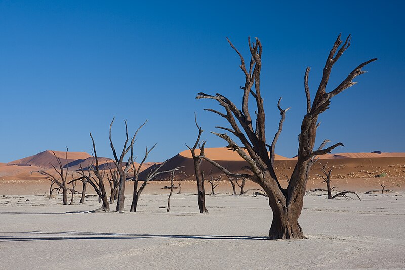
| This is a featured picture, which means that members of the community have identified it as one of the finest images on the English Wikipedia, adding significantly to its accompanying article. If you have a different image of similar quality, be sure to upload it using the proper free license tag, add it to a relevant article, and nominate it. |
|
| This image was selected as picture of the day on the English Wikipedia for May 28, 2011. |
|

This image was selected as
picture of the day on Wikimedia Commons for
29 September 2010. It was captioned as follows: English: Dead acacia trees in Dead Vlei,
Namibia Other languages:
English: Dead acacia trees in Dead Vlei,
Namibia Nederlands: Dode
acaciabomen in de Namibiaanse Dead Vlei (nationaal park Namib-Naukluft). Македонски: Исушени акации во Дед Влеј, Намибија മലയാളം : ഉണങ്ങിപ്പോയ അക്കേഷ്യാ മരങ്ങൾ.
നമീബിയയിലെ ഡെഡ് വ്ലീയിൽ നിന്നും 日本語: ナミビアの
デッド・フレイに立ち並ぶアカシアの枯木。 |
Summary
| Description |
Afrikaans: Afgestorwe Kameeldorings in Dooievlei, naby Sossusvlei, Namibië
Deutsch: Abgestorbene Akazien (Acacia erioloba) im Dead Vlei, in der nähe von Sossusvlei, Namibia
|
| Date | |
| Source | Own work |
| Author | Ikiwaner |
| Permission ( Reusing this file) |
GNU Free Documentation License v1.2 only |
| Other versions |


 |
| Camera location |
| View this and other nearby images on: OpenStreetMap |
|
|---|

|
Permission is granted to copy, distribute and/or modify this document under the terms of the GNU Free Documentation License, Version 1.2 only as published by the Free Software Foundation; with no Invariant Sections, no Front-Cover Texts, and no Back-Cover Texts. A copy of the license is included in the section entitled GNU Free Documentation License. | 1.2 only |
File history
Click on a date/time to view the file as it appeared at that time.
| Date/Time | Thumbnail | Dimensions | User | Comment | |
|---|---|---|---|---|---|
| current | 18:31, 19 October 2009 |
| 3,787 × 2,525 (2.64 MB) | Ikiwaner | {{Information |Description={{de|Abgestorbene Akazien im Dead vlei, Namibia}} |Source={{Own}} |Date=siehe Bild-Metadaten |Author= Ikiwaner |Permission=GNU Free Documentation License v1.2 only |other_versions= }} {{GFDL-1.2}} [[Category:D |
File usage
- Deadvlei
- Namib-Naukluft National Park
- Vlei
- Talk:Deadvlei
- User:Kerowyn
- User talk:Ikiwaner
- Wikipedia:Featured picture candidates/File:Dead Vlei 4.jpg
- Wikipedia:Featured picture candidates/November-2009
- Wikipedia:Featured pictures/Places/Landscapes
- Wikipedia:Featured pictures thumbs/21
- Wikipedia:Main Page history/2011 May 28
- Wikipedia:Picture of the day/May 2011
- Wikipedia:WikiProject Protected areas
- Wikipedia:Wikipedia Signpost/2009-11-16/Features and admins
- Wikipedia:Wikipedia Signpost/2009-11-16/SPV
- Wikipedia:Wikipedia Signpost/Single/2009-11-16
- Template:POTD/2011-05-28
- Portal:Geography
- Portal:Geography/Featured picture
- Portal:Geography/Featured picture/11
- Portal:Geology
Global file usage
The following other wikis use this file:
- Usage on af.wikipedia.org
- Usage on bn.wikipedia.org
- Usage on ca.wikipedia.org
- Usage on crh.wikipedia.org
- Usage on cv.wikipedia.org
- Usage on da.wikipedia.org
- Usage on de.wikipedia.org
- Naturschutzgebiete in Namibia
- Wikipedia:Exzellente Bilder/Landschaften
- Wikipedia:Kandidaten für exzellente Bilder/Archiv2009/18
- Datei:Dead Vlei 4.jpg
- Namib-Skelettküste-Nationalpark
- Benutzer:Der Wolf im Wald/Lieblingsbilder
- Wikipedia:Diskussionen über Bilder/Archiv/2010/Jan
- Portal:Afrika/Unsere besten Bilder
- Benutzer Diskussion:MBq/Archiv/2017
- Usage on eo.wikipedia.org
- Usage on es.wikipedia.org
- Usage on fa.wikipedia.org
- Usage on fr.wikipedia.org
- Usage on gn.wikipedia.org
- Usage on he.wikipedia.org
- Usage on hr.wikipedia.org
- Usage on hu.wikipedia.org
- Usage on ja.wikipedia.org
- Usage on ka.wikipedia.org
- Usage on ko.wikipedia.org
- Usage on kw.wikipedia.org
- Usage on lbe.wikipedia.org
- Usage on mg.wikipedia.org
- Usage on mk.wikipedia.org
- Usage on ml.wikipedia.org
- Usage on mt.wikipedia.org
- Usage on nl.wikipedia.org
View more global usage of this file.
Metadata
Original file (3,787 × 2,525 pixels, file size: 2.64 MB, MIME type: image/jpeg)
| This is a file from the
Wikimedia Commons. Information from its
description page there is shown below. Commons is a freely licensed media file repository. You can help. |
|
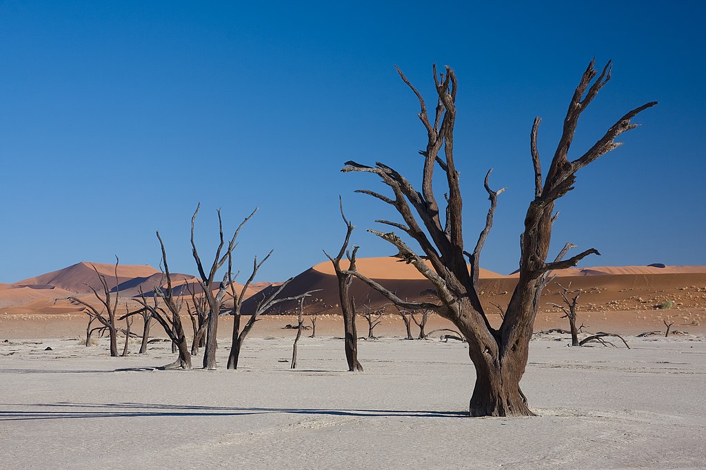
| This is a featured picture, which means that members of the community have identified it as one of the finest images on the English Wikipedia, adding significantly to its accompanying article. If you have a different image of similar quality, be sure to upload it using the proper free license tag, add it to a relevant article, and nominate it. |
|
| This image was selected as picture of the day on the English Wikipedia for May 28, 2011. |
|
This image was selected as
picture of the day on Wikimedia Commons for
29 September 2010. It was captioned as follows: English: Dead acacia trees in Dead Vlei,
Namibia Other languages:
English: Dead acacia trees in Dead Vlei,
Namibia Nederlands: Dode
acaciabomen in de Namibiaanse Dead Vlei (nationaal park Namib-Naukluft). Македонски: Исушени акации во Дед Влеј, Намибија മലയാളം : ഉണങ്ങിപ്പോയ അക്കേഷ്യാ മരങ്ങൾ.
നമീബിയയിലെ ഡെഡ് വ്ലീയിൽ നിന്നും 日本語: ナミビアの
デッド・フレイに立ち並ぶアカシアの枯木。 |
Summary
| Description |
Afrikaans: Afgestorwe Kameeldorings in Dooievlei, naby Sossusvlei, Namibië
Deutsch: Abgestorbene Akazien (Acacia erioloba) im Dead Vlei, in der nähe von Sossusvlei, Namibia
|
| Date | |
| Source | Own work |
| Author | Ikiwaner |
| Permission ( Reusing this file) |
GNU Free Documentation License v1.2 only |
| Other versions |
|
| Camera location |
| View this and other nearby images on: OpenStreetMap |
|
|---|
|
|
Permission is granted to copy, distribute and/or modify this document under the terms of the GNU Free Documentation License, Version 1.2 only as published by the Free Software Foundation; with no Invariant Sections, no Front-Cover Texts, and no Back-Cover Texts. A copy of the license is included in the section entitled GNU Free Documentation License. | 1.2 only |
File history
Click on a date/time to view the file as it appeared at that time.
| Date/Time | Thumbnail | Dimensions | User | Comment | |
|---|---|---|---|---|---|
| current | 18:31, 19 October 2009 |
| 3,787 × 2,525 (2.64 MB) | Ikiwaner | {{Information |Description={{de|Abgestorbene Akazien im Dead vlei, Namibia}} |Source={{Own}} |Date=siehe Bild-Metadaten |Author= Ikiwaner |Permission=GNU Free Documentation License v1.2 only |other_versions= }} {{GFDL-1.2}} [[Category:D |
File usage
- Deadvlei
- Namib-Naukluft National Park
- Vlei
- Talk:Deadvlei
- User:Kerowyn
- User talk:Ikiwaner
- Wikipedia:Featured picture candidates/File:Dead Vlei 4.jpg
- Wikipedia:Featured picture candidates/November-2009
- Wikipedia:Featured pictures/Places/Landscapes
- Wikipedia:Featured pictures thumbs/21
- Wikipedia:Main Page history/2011 May 28
- Wikipedia:Picture of the day/May 2011
- Wikipedia:WikiProject Protected areas
- Wikipedia:Wikipedia Signpost/2009-11-16/Features and admins
- Wikipedia:Wikipedia Signpost/2009-11-16/SPV
- Wikipedia:Wikipedia Signpost/Single/2009-11-16
- Template:POTD/2011-05-28
- Portal:Geography
- Portal:Geography/Featured picture
- Portal:Geography/Featured picture/11
- Portal:Geology
Global file usage
The following other wikis use this file:
- Usage on af.wikipedia.org
- Usage on bn.wikipedia.org
- Usage on ca.wikipedia.org
- Usage on crh.wikipedia.org
- Usage on cv.wikipedia.org
- Usage on da.wikipedia.org
- Usage on de.wikipedia.org
- Naturschutzgebiete in Namibia
- Wikipedia:Exzellente Bilder/Landschaften
- Wikipedia:Kandidaten für exzellente Bilder/Archiv2009/18
- Datei:Dead Vlei 4.jpg
- Namib-Skelettküste-Nationalpark
- Benutzer:Der Wolf im Wald/Lieblingsbilder
- Wikipedia:Diskussionen über Bilder/Archiv/2010/Jan
- Portal:Afrika/Unsere besten Bilder
- Benutzer Diskussion:MBq/Archiv/2017
- Usage on eo.wikipedia.org
- Usage on es.wikipedia.org
- Usage on fa.wikipedia.org
- Usage on fr.wikipedia.org
- Usage on gn.wikipedia.org
- Usage on he.wikipedia.org
- Usage on hr.wikipedia.org
- Usage on hu.wikipedia.org
- Usage on ja.wikipedia.org
- Usage on ka.wikipedia.org
- Usage on ko.wikipedia.org
- Usage on kw.wikipedia.org
- Usage on lbe.wikipedia.org
- Usage on mg.wikipedia.org
- Usage on mk.wikipedia.org
- Usage on ml.wikipedia.org
- Usage on mt.wikipedia.org
- Usage on nl.wikipedia.org
View more global usage of this file.