Photos • Location


Size of this preview:
800 × 380 pixels. Other resolutions:
320 × 152 pixels |
640 × 304 pixels |
1,024 × 486 pixels |
1,280 × 608 pixels |
3,370 × 1,600 pixels.
Original file (3,370 × 1,600 pixels, file size: 1.2 MB, MIME type: image/jpeg)
| This is a file from the
Wikimedia Commons. Information from its
description page there is shown below. Commons is a freely licensed media file repository. You can help. |
Summary
| Camera location |
| View this and other nearby images on: OpenStreetMap |
|
|---|
| Description |
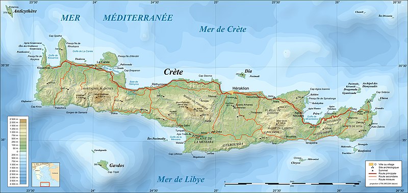
UTM projection; WGS84 datum; shaded relief (composite image of N-W, W and N lightning positions)
|
||
| Date | |||
| Source |
Own work;
|
||
| Author | Eric Gaba ( Sting) | ||
| Permission ( Reusing this file) |
|
||
| Other versions |
|


Licensing
I, the copyright holder of this work, hereby publish it under the following licenses:

|
Permission is granted to copy, distribute and/or modify this document under the terms of the GNU Free Documentation License, Version 1.2 or any later version published by the Free Software Foundation; with no Invariant Sections, no Front-Cover Texts, and no Back-Cover Texts. A copy of the license is included in the section entitled GNU Free Documentation License. |
This file is licensed under the
Creative Commons Attribution-Share Alike
4.0 International,
3.0 Unported,
2.5 Generic,
2.0 Generic and
1.0 Generic license.
- You are free:
- to share – to copy, distribute and transmit the work
- to remix – to adapt the work
- Under the following conditions:
- attribution – You must give appropriate credit, provide a link to the license, and indicate if changes were made. You may do so in any reasonable manner, but not in any way that suggests the licensor endorses you or your use.
- share alike – If you remix, transform, or build upon the material, you must distribute your contributions under the same or compatible license as the original.
You may select the license of your choice.
File history
Click on a date/time to view the file as it appeared at that time.
| Date/Time | Thumbnail | Dimensions | User | Comment | |
|---|---|---|---|---|---|
| current | 22:04, 17 July 2010 |
| 3,370 × 1,600 (1.2 MB) | Sting | Color profile |
| 20:05, 17 June 2008 |
 | 3,370 × 1,600 (1.18 MB) | Sting | == Summary == {{Location|35|20|00|N|25|00|00|E|scale:2000000}} <br/> {{Information |Description={{en|Topographic map in French of Crete island, Greece.}} {{fr|Carte topographique en français de l'île de Crète |
File usage
The following pages on the English Wikipedia use this file (pages on other projects are not listed):
Global file usage
The following other wikis use this file:
- Usage on fr.wikipedia.org
- Usage on mg.wikipedia.org
- Usage on oc.wikipedia.org
Metadata
Size of this preview:
800 × 380 pixels. Other resolutions:
320 × 152 pixels |
640 × 304 pixels |
1,024 × 486 pixels |
1,280 × 608 pixels |
3,370 × 1,600 pixels.
Original file (3,370 × 1,600 pixels, file size: 1.2 MB, MIME type: image/jpeg)
| This is a file from the
Wikimedia Commons. Information from its
description page there is shown below. Commons is a freely licensed media file repository. You can help. |
Summary
| Camera location |
| View this and other nearby images on: OpenStreetMap |
|
|---|
| Description |
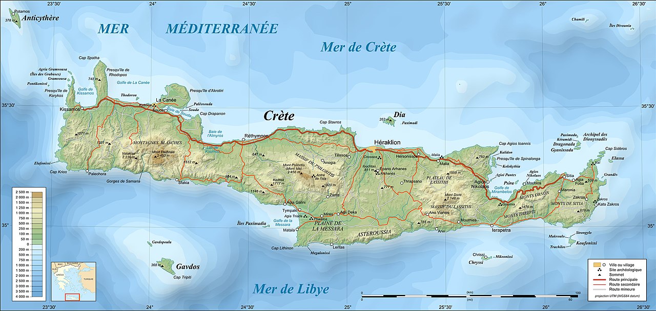
UTM projection; WGS84 datum; shaded relief (composite image of N-W, W and N lightning positions)
|
||
| Date | |||
| Source |
Own work;
|
||
| Author | Eric Gaba ( Sting) | ||
| Permission ( Reusing this file) |
|
||
| Other versions |
|
Licensing
I, the copyright holder of this work, hereby publish it under the following licenses:
|
|
Permission is granted to copy, distribute and/or modify this document under the terms of the GNU Free Documentation License, Version 1.2 or any later version published by the Free Software Foundation; with no Invariant Sections, no Front-Cover Texts, and no Back-Cover Texts. A copy of the license is included in the section entitled GNU Free Documentation License. |
This file is licensed under the
Creative Commons Attribution-Share Alike
4.0 International,
3.0 Unported,
2.5 Generic,
2.0 Generic and
1.0 Generic license.
- You are free:
- to share – to copy, distribute and transmit the work
- to remix – to adapt the work
- Under the following conditions:
- attribution – You must give appropriate credit, provide a link to the license, and indicate if changes were made. You may do so in any reasonable manner, but not in any way that suggests the licensor endorses you or your use.
- share alike – If you remix, transform, or build upon the material, you must distribute your contributions under the same or compatible license as the original.
You may select the license of your choice.
File history
Click on a date/time to view the file as it appeared at that time.
| Date/Time | Thumbnail | Dimensions | User | Comment | |
|---|---|---|---|---|---|
| current | 22:04, 17 July 2010 |
| 3,370 × 1,600 (1.2 MB) | Sting | Color profile |
| 20:05, 17 June 2008 |
| 3,370 × 1,600 (1.18 MB) | Sting | == Summary == {{Location|35|20|00|N|25|00|00|E|scale:2000000}} <br/> {{Information |Description={{en|Topographic map in French of Crete island, Greece.}} {{fr|Carte topographique en français de l'île de Crète |
File usage
The following pages on the English Wikipedia use this file (pages on other projects are not listed):
Global file usage
The following other wikis use this file:
- Usage on fr.wikipedia.org
- Usage on mg.wikipedia.org
- Usage on oc.wikipedia.org