
Size of this PNG preview of this SVG file:
800 × 406 pixels. Other resolutions:
320 × 162 pixels |
640 × 325 pixels |
1,024 × 520 pixels |
1,280 × 650 pixels |
2,560 × 1,300 pixels |
2,754 × 1,398 pixels.
Original file (SVG file, nominally 2,754 × 1,398 pixels, file size: 1.05 MB)
| This is a file from the
Wikimedia Commons. Information from its
description page there is shown below. Commons is a freely licensed media file repository. You can help. |

.svg)
Summary
| Description |
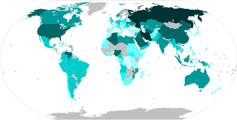
English: Countries by natural gas proven reserves (2014), based on data from
The World Factbook.
≥ 10,000 km3 ≥ 3,000 km3 ≥ 1,000 km3 ≥ 100 km3 ≥ 50 km3 ≥ 10 km3 ≥ 1 km3 > 0 km3 0 km3 |
| Date | |
| Source | Own work based on File:BlankMap-World.svg |
| Author | Ali Zifan |
Licensing
I, the copyright holder of this work, hereby publish it under the following license:
| This file is made available under the Creative Commons CC0 1.0 Universal Public Domain Dedication. | |
| The person who associated a work with this deed has dedicated the work to the
public domain by waiving all of their rights to the work worldwide under copyright law, including all related and neighboring rights, to the extent allowed by law. You can copy, modify, distribute and perform the work, even for commercial purposes, all without asking permission.
|
File history
Click on a date/time to view the file as it appeared at that time.
| Date/Time | Thumbnail | Dimensions | User | Comment | |
|---|---|---|---|---|---|
| current | 18:25, 6 December 2019 |
| 2,754 × 1,398 (1.05 MB) | Rino ap Codkelden | By changes made, Crimean peninsula depicted as a territory of Ukraine (see Talk page for details about accordance with UNGA [https://undocs.org/en/A/RES/68/262 Resolution 68/262], adopted on March 27, 2014. |
| 00:29, 19 November 2019 |
 | 2,754 × 1,398 (1.05 MB) | Getsnoopy | Changed the source to original BlankMap-World.svg to show Earth's elliptical outline, to fix some distorted countries, and to make the image locale-independent. | |
| 15:09, 21 September 2015 |
 | 863 × 396 (1.22 MB) | Oganesson007 | User created page with UploadWizard |
File usage
The following pages on the English Wikipedia use this file (pages on other projects are not listed):
- Economy of Iran
- Economy of Russia
- Economy of the United States
- Energy in Algeria
- Energy in Norway
- Energy policy of Canada
- Energy policy of China
- Energy policy of Russia
- Energy policy of Venezuela
- Energy security
- Gazprom
- Global energy crisis (2021–present)
- List of countries by natural gas production
- List of countries by natural gas proven reserves
- Natural gas
- Natural gas by country
- Natural gas in Iran
- Nord Stream 1
- Russia under Vladimir Putin
- World energy resources
- User:Oganesson007/World Maps
- Portal:Energy
Global file usage
The following other wikis use this file:
- Usage on ar.wikipedia.org
- Usage on az.wikipedia.org
- Usage on bg.wikipedia.org
- Usage on ca.wikipedia.org
- Usage on cs.wikipedia.org
- Usage on de.wikipedia.org
- Usage on es.wikipedia.org
- Usage on et.wikipedia.org
- Usage on fa.wikipedia.org
- Usage on fr.wikipedia.org
- Usage on hi.wikipedia.org
- Usage on hu.wikipedia.org
- Usage on hy.wikipedia.org
- Usage on ko.wikipedia.org
- Usage on mk.wikipedia.org
- Usage on nl.wikipedia.org
- Usage on pl.wikipedia.org
- Usage on pt.wikipedia.org
- Usage on sr.wikipedia.org
- Usage on sv.wikipedia.org
- Usage on test.wikipedia.org
- Usage on te.wikipedia.org
- Usage on th.wikipedia.org
- Usage on tr.wikipedia.org
- Usage on uk.wikipedia.org
- Usage on uz.wikipedia.org
- Usage on vi.wikipedia.org
Metadata
.svg)
Size of this PNG preview of this SVG file:
800 × 406 pixels. Other resolutions:
320 × 162 pixels |
640 × 325 pixels |
1,024 × 520 pixels |
1,280 × 650 pixels |
2,560 × 1,300 pixels |
2,754 × 1,398 pixels.
Original file (SVG file, nominally 2,754 × 1,398 pixels, file size: 1.05 MB)
| This is a file from the
Wikimedia Commons. Information from its
description page there is shown below. Commons is a freely licensed media file repository. You can help. |
Summary
| Description |
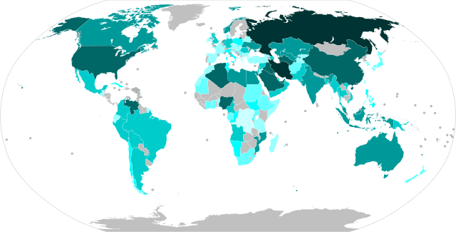
English: Countries by natural gas proven reserves (2014), based on data from
The World Factbook.
≥ 10,000 km3 ≥ 3,000 km3 ≥ 1,000 km3 ≥ 100 km3 ≥ 50 km3 ≥ 10 km3 ≥ 1 km3 > 0 km3 0 km3 |
| Date | |
| Source | Own work based on File:BlankMap-World.svg |
| Author | Ali Zifan |
Licensing
I, the copyright holder of this work, hereby publish it under the following license:
| This file is made available under the Creative Commons CC0 1.0 Universal Public Domain Dedication. | |
| The person who associated a work with this deed has dedicated the work to the
public domain by waiving all of their rights to the work worldwide under copyright law, including all related and neighboring rights, to the extent allowed by law. You can copy, modify, distribute and perform the work, even for commercial purposes, all without asking permission.
|
File history
Click on a date/time to view the file as it appeared at that time.
| Date/Time | Thumbnail | Dimensions | User | Comment | |
|---|---|---|---|---|---|
| current | 18:25, 6 December 2019 |
| 2,754 × 1,398 (1.05 MB) | Rino ap Codkelden | By changes made, Crimean peninsula depicted as a territory of Ukraine (see Talk page for details about accordance with UNGA [https://undocs.org/en/A/RES/68/262 Resolution 68/262], adopted on March 27, 2014. |
| 00:29, 19 November 2019 |
| 2,754 × 1,398 (1.05 MB) | Getsnoopy | Changed the source to original BlankMap-World.svg to show Earth's elliptical outline, to fix some distorted countries, and to make the image locale-independent. | |
| 15:09, 21 September 2015 |
| 863 × 396 (1.22 MB) | Oganesson007 | User created page with UploadWizard |
File usage
The following pages on the English Wikipedia use this file (pages on other projects are not listed):
- Economy of Iran
- Economy of Russia
- Economy of the United States
- Energy in Algeria
- Energy in Norway
- Energy policy of Canada
- Energy policy of China
- Energy policy of Russia
- Energy policy of Venezuela
- Energy security
- Gazprom
- Global energy crisis (2021–present)
- List of countries by natural gas production
- List of countries by natural gas proven reserves
- Natural gas
- Natural gas by country
- Natural gas in Iran
- Nord Stream 1
- Russia under Vladimir Putin
- World energy resources
- User:Oganesson007/World Maps
- Portal:Energy
Global file usage
The following other wikis use this file:
- Usage on ar.wikipedia.org
- Usage on az.wikipedia.org
- Usage on bg.wikipedia.org
- Usage on ca.wikipedia.org
- Usage on cs.wikipedia.org
- Usage on de.wikipedia.org
- Usage on es.wikipedia.org
- Usage on et.wikipedia.org
- Usage on fa.wikipedia.org
- Usage on fr.wikipedia.org
- Usage on hi.wikipedia.org
- Usage on hu.wikipedia.org
- Usage on hy.wikipedia.org
- Usage on ko.wikipedia.org
- Usage on mk.wikipedia.org
- Usage on nl.wikipedia.org
- Usage on pl.wikipedia.org
- Usage on pt.wikipedia.org
- Usage on sr.wikipedia.org
- Usage on sv.wikipedia.org
- Usage on test.wikipedia.org
- Usage on te.wikipedia.org
- Usage on th.wikipedia.org
- Usage on tr.wikipedia.org
- Usage on uk.wikipedia.org
- Usage on uz.wikipedia.org
- Usage on vi.wikipedia.org