
Original file (4,000 × 3,000 pixels, file size: 3.32 MB, MIME type: image/jpeg)
| This is a file from the
Wikimedia Commons. Information from its
description page there is shown below. Commons is a freely licensed media file repository. You can help. |
,_Chicago,_Illinois_(9179587177).jpg)
Summary
| Description |
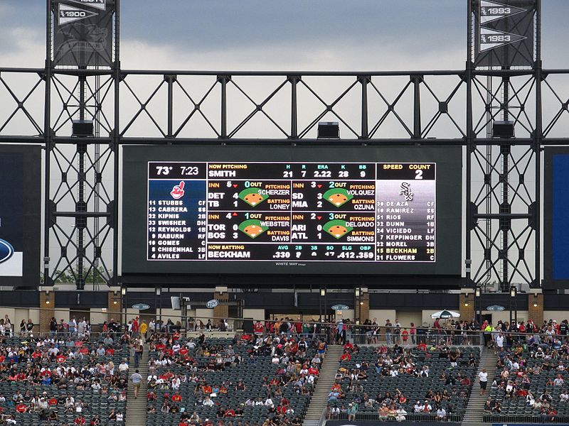
Cleveland Indians v. Chicago White Sox U.S. Cellular Field (formerly Comiskey Park) is a baseball park in Chicago, Illinois. It is the home of the Chicago White Sox of Major League Baseball's American League. The park is owned by the Illinois Sports Facilities Authority, but operated by the White Sox. The park opened for the 1991 season, after the White Sox had spent 81 years at the original Comiskey Park. The new park, completed at a cost of US$167 million, also opened with the Comiskey Park name, but became U.S. Cellular Field in 2003 after U.S. Cellular bought the naming rights at $68 million over 20 years. It hosted the MLB All-Star Game that same year. Many sportscasters and fans continue to use the name Comiskey Park. Prior to its demolition, the old Comiskey Park was the oldest in-use ballpark in Major League Baseball, a title now held by Fenway Park in Boston. The stadium is situated just to the west of the Dan Ryan Expressway in Chicago's Armour Square neighborhood. It was built directly across 35th Street from old Comiskey Park, which was demolished to make room for a parking lot that serves the venue. Old Comiskey's home plate is a marble plaque on the sidewalk next to U.S. Cellular Field and the foul lines are painted in the parking lot. Also, the spectator ramp across 35th Street is designed in such a way (partly curved, partly straight but angling east-northeast) that it echoes the contour of the old first-base grandstand. en.wikipedia.org/wiki/U.S._Cellular_Field en.wikipedia.org/wiki/Wikipedia:Text_of_Creative_Commons_... |
| Date | |
| Source | Cleveland Indians v. Chicago White Sox, U.S. Cellular Field (Comiskey Park), Chicago, Illinois |
| Author | Ken Lund from Reno, Nevada, USA |
| Camera location |
| View this and other nearby images on: OpenStreetMap |
|
|---|
,_Chicago,_Illinois_(9179587177).jpg¶ms=041.830496_N_-087.633926_E_globe:Earth_type:camera_source:Flickr_&language=en)
Licensing
- You are free:
- to share – to copy, distribute and transmit the work
- to remix – to adapt the work
- Under the following conditions:
- attribution – You must give appropriate credit, provide a link to the license, and indicate if changes were made. You may do so in any reasonable manner, but not in any way that suggests the licensor endorses you or your use.
- share alike – If you remix, transform, or build upon the material, you must distribute your contributions under the same or compatible license as the original.
| This image was originally posted to Flickr by Ken Lund at https://flickr.com/photos/75683070@N00/9179587177. It was reviewed on 2 March 2017 by FlickreviewR and was confirmed to be licensed under the terms of the cc-by-sa-2.0. |
File history
Click on a date/time to view the file as it appeared at that time.
| Date/Time | Thumbnail | Dimensions | User | Comment | |
|---|---|---|---|---|---|
| current | 03:01, 2 March 2017 |
| 4,000 × 3,000 (3.32 MB) | Victorgrigas | Transferred from Flickr via Flickr2Commons |
File usage
Metadata
,_Chicago,_Illinois_(9179587177).jpg)
Original file (4,000 × 3,000 pixels, file size: 3.32 MB, MIME type: image/jpeg)
| This is a file from the
Wikimedia Commons. Information from its
description page there is shown below. Commons is a freely licensed media file repository. You can help. |
Summary
| Description |
Cleveland Indians v. Chicago White Sox U.S. Cellular Field (formerly Comiskey Park) is a baseball park in Chicago, Illinois. It is the home of the Chicago White Sox of Major League Baseball's American League. The park is owned by the Illinois Sports Facilities Authority, but operated by the White Sox. The park opened for the 1991 season, after the White Sox had spent 81 years at the original Comiskey Park. The new park, completed at a cost of US$167 million, also opened with the Comiskey Park name, but became U.S. Cellular Field in 2003 after U.S. Cellular bought the naming rights at $68 million over 20 years. It hosted the MLB All-Star Game that same year. Many sportscasters and fans continue to use the name Comiskey Park. Prior to its demolition, the old Comiskey Park was the oldest in-use ballpark in Major League Baseball, a title now held by Fenway Park in Boston. The stadium is situated just to the west of the Dan Ryan Expressway in Chicago's Armour Square neighborhood. It was built directly across 35th Street from old Comiskey Park, which was demolished to make room for a parking lot that serves the venue. Old Comiskey's home plate is a marble plaque on the sidewalk next to U.S. Cellular Field and the foul lines are painted in the parking lot. Also, the spectator ramp across 35th Street is designed in such a way (partly curved, partly straight but angling east-northeast) that it echoes the contour of the old first-base grandstand. en.wikipedia.org/wiki/U.S._Cellular_Field en.wikipedia.org/wiki/Wikipedia:Text_of_Creative_Commons_... |
| Date | |
| Source | Cleveland Indians v. Chicago White Sox, U.S. Cellular Field (Comiskey Park), Chicago, Illinois |
| Author | Ken Lund from Reno, Nevada, USA |
| Camera location |
| View this and other nearby images on: OpenStreetMap |
|
|---|
Licensing
- You are free:
- to share – to copy, distribute and transmit the work
- to remix – to adapt the work
- Under the following conditions:
- attribution – You must give appropriate credit, provide a link to the license, and indicate if changes were made. You may do so in any reasonable manner, but not in any way that suggests the licensor endorses you or your use.
- share alike – If you remix, transform, or build upon the material, you must distribute your contributions under the same or compatible license as the original.
| This image was originally posted to Flickr by Ken Lund at https://flickr.com/photos/75683070@N00/9179587177. It was reviewed on 2 March 2017 by FlickreviewR and was confirmed to be licensed under the terms of the cc-by-sa-2.0. |
File history
Click on a date/time to view the file as it appeared at that time.
| Date/Time | Thumbnail | Dimensions | User | Comment | |
|---|---|---|---|---|---|
| current | 03:01, 2 March 2017 |
| 4,000 × 3,000 (3.32 MB) | Victorgrigas | Transferred from Flickr via Flickr2Commons |