
Size of this preview:
600 × 599 pixels. Other resolutions:
240 × 240 pixels |
480 × 480 pixels |
1,001 × 1,000 pixels.
Original file (1,001 × 1,000 pixels, file size: 1.46 MB, MIME type: image/png)
| This is a file from the
Wikimedia Commons. Information from its
description page there is shown below. Commons is a freely licensed media file repository. You can help. |
Summary
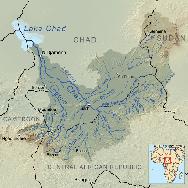
| Description | Map showing the Chari River drainage basin. |
| Date | |
| Source | Own work, Elevation data from SRTM, drainage basin from GTOPO [1], all other features from Vector Map. |
| Author | Kmusser |
Licensing
I, the copyright holder of this work, hereby publish it under the following license:
This file is licensed under the
Creative Commons
Attribution-Share Alike 3.0 Unported license.
- You are free:
- to share – to copy, distribute and transmit the work
- to remix – to adapt the work
- Under the following conditions:
- attribution – You must give appropriate credit, provide a link to the license, and indicate if changes were made. You may do so in any reasonable manner, but not in any way that suggests the licensor endorses you or your use.
- share alike – If you remix, transform, or build upon the material, you must distribute your contributions under the same or compatible license as the original.
File history
Click on a date/time to view the file as it appeared at that time.
| Date/Time | Thumbnail | Dimensions | User | Comment | |
|---|---|---|---|---|---|
| current | 16:26, 28 September 2010 |
| 1,001 × 1,000 (1.46 MB) | Kmusser | connect Azoum and Salamat |
| 18:36, 8 April 2010 |
 | 1,000 × 1,000 (1.57 MB) | Kmusser | == Summary == {{Information |Description=Map showing the Chari River drainage basin. |Source={{own}}, Elevation data from SRTM, drainage basin from GTOPO [http://eros.usgs.gov/#/Find_Data/Products |
File usage
The following pages on the English Wikipedia use this file (pages on other projects are not listed):
Global file usage
The following other wikis use this file:
- Usage on af.wikipedia.org
- Usage on ar.wikipedia.org
- Usage on arz.wikipedia.org
- Usage on be.wikipedia.org
- Usage on bg.wikipedia.org
- Usage on ca.wikipedia.org
- Usage on ceb.wikipedia.org
- Usage on cs.wikipedia.org
- Usage on de.wikipedia.org
- Schari
- Logone
- Ouham
- Tschadbecken
- Salamat (Fluss)
- Bahr Aouk
- Nana Barya
- Pendé (Fluss)
- Fafa (Ouham)
- Mbéré (Fluss)
- Wikipedia:Löschkandidaten/5. Februar 2018
- Liste der Flüsse in der Zentralafrikanischen Republik
- Liste der Flüsse in Kamerun
- Vina (Mbéré)
- Liste der Flüsse im Tschad
- Logone Occidental (Fluss)
- Liste der Flüsse im Sudan
- Usage on el.wikipedia.org
- Usage on eo.wikipedia.org
- Usage on es.wikipedia.org
- Usage on eu.wikipedia.org
- Usage on fa.wikipedia.org
- Usage on fi.wikipedia.org
- Usage on fr.wikipedia.org
View more global usage of this file.
Size of this preview:
600 × 599 pixels. Other resolutions:
240 × 240 pixels |
480 × 480 pixels |
1,001 × 1,000 pixels.
Original file (1,001 × 1,000 pixels, file size: 1.46 MB, MIME type: image/png)
| This is a file from the
Wikimedia Commons. Information from its
description page there is shown below. Commons is a freely licensed media file repository. You can help. |
Summary
| Description | Map showing the Chari River drainage basin. |
| Date | |
| Source | Own work, Elevation data from SRTM, drainage basin from GTOPO [1], all other features from Vector Map. |
| Author | Kmusser |
Licensing
I, the copyright holder of this work, hereby publish it under the following license:
This file is licensed under the
Creative Commons
Attribution-Share Alike 3.0 Unported license.
- You are free:
- to share – to copy, distribute and transmit the work
- to remix – to adapt the work
- Under the following conditions:
- attribution – You must give appropriate credit, provide a link to the license, and indicate if changes were made. You may do so in any reasonable manner, but not in any way that suggests the licensor endorses you or your use.
- share alike – If you remix, transform, or build upon the material, you must distribute your contributions under the same or compatible license as the original.
File history
Click on a date/time to view the file as it appeared at that time.
| Date/Time | Thumbnail | Dimensions | User | Comment | |
|---|---|---|---|---|---|
| current | 16:26, 28 September 2010 |
| 1,001 × 1,000 (1.46 MB) | Kmusser | connect Azoum and Salamat |
| 18:36, 8 April 2010 |
| 1,000 × 1,000 (1.57 MB) | Kmusser | == Summary == {{Information |Description=Map showing the Chari River drainage basin. |Source={{own}}, Elevation data from SRTM, drainage basin from GTOPO [http://eros.usgs.gov/#/Find_Data/Products |
File usage
The following pages on the English Wikipedia use this file (pages on other projects are not listed):
Global file usage
The following other wikis use this file:
- Usage on af.wikipedia.org
- Usage on ar.wikipedia.org
- Usage on arz.wikipedia.org
- Usage on be.wikipedia.org
- Usage on bg.wikipedia.org
- Usage on ca.wikipedia.org
- Usage on ceb.wikipedia.org
- Usage on cs.wikipedia.org
- Usage on de.wikipedia.org
- Schari
- Logone
- Ouham
- Tschadbecken
- Salamat (Fluss)
- Bahr Aouk
- Nana Barya
- Pendé (Fluss)
- Fafa (Ouham)
- Mbéré (Fluss)
- Wikipedia:Löschkandidaten/5. Februar 2018
- Liste der Flüsse in der Zentralafrikanischen Republik
- Liste der Flüsse in Kamerun
- Vina (Mbéré)
- Liste der Flüsse im Tschad
- Logone Occidental (Fluss)
- Liste der Flüsse im Sudan
- Usage on el.wikipedia.org
- Usage on eo.wikipedia.org
- Usage on es.wikipedia.org
- Usage on eu.wikipedia.org
- Usage on fa.wikipedia.org
- Usage on fi.wikipedia.org
- Usage on fr.wikipedia.org
View more global usage of this file.