No higher resolution available.
Central_African_Republic-CIA_WFB_Map.png (328 × 352 pixels, file size: 49 KB, MIME type: image/png)
| This is a file from the
Wikimedia Commons. Information from its
description page there is shown below. Commons is a freely licensed media file repository. You can help. |
Summary
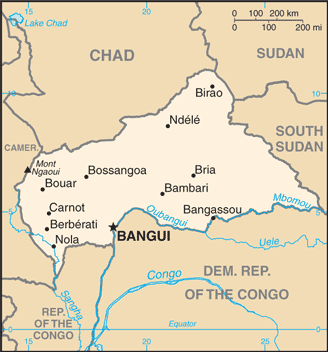
| Description | Central African Republic map from CIA World Factbook, converted from original GIF format (July 2011 version showing South Sudan) |
| Date | |
| Source |
CIA World Factbook |
| Author | United States Central Intelligence Agency |
| Other versions |
Licensing
This image is in the
public domain because it contains materials that originally came from the United States
Central Intelligence Agency's
World Factbook.
|
 |
Derivative works
Derivatives of 2011 map (showing South Sudan):
-
 Central African Republic-map-blank.png
 -
 Republique centrafricaine carte.gif
français -
 Centra Afrika Respubliko.png
Esperanto


Derivatives of 2004 map (not showing South Sudan):
-
 Central African Republic CIA map PL.jpg
polski -
 Mapa stredoafricke rep.png
čeština -
 SAR-kaart.png
Afrikaans


.png)
File history
Click on a date/time to view the file as it appeared at that time.
| Date/Time | Thumbnail | Dimensions | User | Comment | |
|---|---|---|---|---|---|
| current | 00:08, 13 July 2011 |
| 328 × 352 (49 KB) | Béka~commonswiki | new version with South Sudan, from CIA |
| 09:12, 27 March 2005 |
 | 326 × 350 (11 KB) | Wolfman~commonswiki | {{CIA-map}} |
File usage
The following pages on the English Wikipedia use this file (pages on other projects are not listed):
- Alexandre Banza
- Central African Republic–Sudan border
- Jean Izamo
- List of cities in the Central African Republic
- Petroleum industry in Nigeria
- Saint-Sylvestre coup d'état
- United Nations Mission in the Central African Republic
- United Nations Security Council Resolution 1271
- User:Mhs79/sandbox
- Module:Location map/data/Central African Republic
- Module:Location map/data/Central African Republic/doc
Global file usage
The following other wikis use this file:
- Usage on ar.wikipedia.org
- Usage on bcl.wikipedia.org
- Usage on be-tarask.wikipedia.org
- Usage on bs.wikipedia.org
- Usage on ca.wikipedia.org
- Usage on ckb.wikipedia.org
- Usage on cy.wikipedia.org
- Usage on da.wikipedia.org
- Usage on de.wikipedia.org
- Usage on de.wikinews.org
- Usage on en.wikinews.org
- Usage on en.wikisource.org
- Usage on eo.wikipedia.org
- Usage on es.wikipedia.org
- Usage on eu.wikipedia.org
- Usage on fa.wikipedia.org
- Usage on fi.wikipedia.org
- Usage on fi.wikivoyage.org
- Usage on fr.wikipedia.org
- Usage on fr.wikinews.org
- Usage on gd.wikipedia.org
- Usage on hu.wikipedia.org
- Usage on hu.wiktionary.org
- Usage on id.wikipedia.org
- Usage on ilo.wikipedia.org
- Usage on is.wikipedia.org
- Usage on it.wikipedia.org
- Usage on ja.wikipedia.org
View more global usage of this file.
No higher resolution available.
Central_African_Republic-CIA_WFB_Map.png (328 × 352 pixels, file size: 49 KB, MIME type: image/png)
| This is a file from the
Wikimedia Commons. Information from its
description page there is shown below. Commons is a freely licensed media file repository. You can help. |
Summary
| Description | Central African Republic map from CIA World Factbook, converted from original GIF format (July 2011 version showing South Sudan) |
| Date | |
| Source |
CIA World Factbook |
| Author | United States Central Intelligence Agency |
| Other versions |
Licensing
This image is in the
public domain because it contains materials that originally came from the United States
Central Intelligence Agency's
World Factbook.
|
|
Derivative works
Derivatives of 2011 map (showing South Sudan):
-
Central African Republic-map-blank.png
-
Republique centrafricaine carte.gif
français -
Centra Afrika Respubliko.png
Esperanto
Derivatives of 2004 map (not showing South Sudan):
-
Central African Republic CIA map PL.jpg
polski -
Mapa stredoafricke rep.png
čeština -
SAR-kaart.png
Afrikaans
File history
Click on a date/time to view the file as it appeared at that time.
| Date/Time | Thumbnail | Dimensions | User | Comment | |
|---|---|---|---|---|---|
| current | 00:08, 13 July 2011 |
| 328 × 352 (49 KB) | Béka~commonswiki | new version with South Sudan, from CIA |
| 09:12, 27 March 2005 |
| 326 × 350 (11 KB) | Wolfman~commonswiki | {{CIA-map}} |
File usage
The following pages on the English Wikipedia use this file (pages on other projects are not listed):
- Alexandre Banza
- Central African Republic–Sudan border
- Jean Izamo
- List of cities in the Central African Republic
- Petroleum industry in Nigeria
- Saint-Sylvestre coup d'état
- United Nations Mission in the Central African Republic
- United Nations Security Council Resolution 1271
- User:Mhs79/sandbox
- Module:Location map/data/Central African Republic
- Module:Location map/data/Central African Republic/doc
Global file usage
The following other wikis use this file:
- Usage on ar.wikipedia.org
- Usage on bcl.wikipedia.org
- Usage on be-tarask.wikipedia.org
- Usage on bs.wikipedia.org
- Usage on ca.wikipedia.org
- Usage on ckb.wikipedia.org
- Usage on cy.wikipedia.org
- Usage on da.wikipedia.org
- Usage on de.wikipedia.org
- Usage on de.wikinews.org
- Usage on en.wikinews.org
- Usage on en.wikisource.org
- Usage on eo.wikipedia.org
- Usage on es.wikipedia.org
- Usage on eu.wikipedia.org
- Usage on fa.wikipedia.org
- Usage on fi.wikipedia.org
- Usage on fi.wikivoyage.org
- Usage on fr.wikipedia.org
- Usage on fr.wikinews.org
- Usage on gd.wikipedia.org
- Usage on hu.wikipedia.org
- Usage on hu.wiktionary.org
- Usage on id.wikipedia.org
- Usage on ilo.wikipedia.org
- Usage on is.wikipedia.org
- Usage on it.wikipedia.org
- Usage on ja.wikipedia.org
View more global usage of this file.