
Original file (9,378 × 2,296 pixels, file size: 4.59 MB, MIME type: image/jpeg)
| This is a file from the
Wikimedia Commons. Information from its
description page there is shown below. Commons is a freely licensed media file repository. You can help. |
Summary
| Description |
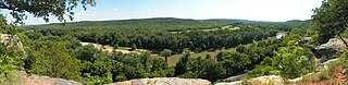
English: A panorama of the
Meramec River valley looking toward the south from atop the bluffs at
Castlewood State Park in
Missouri near
St. Louis.
Across the river are more of the same park and Lone Elk County Park. To the west (right) are Tyson Research Center, West Tyson County Park, and Route 66 State Park. These protected areas, along with additional state conservation lands, create a large greenway named the Henry Shaw Ozark Corridor. This image is a composite of 12 images encompassing approximately 180° horizontally. |
| Source | Own work |
| Author | Kbh3rd |
| Other versions | File:Castlewood SP Panorama 20090705.jpg |
| Camera location |
| View this and other nearby images on: OpenStreetMap |
|
|---|
Licensing
- You are free:
- to share – to copy, distribute and transmit the work
- to remix – to adapt the work
- Under the following conditions:
- attribution – You must give appropriate credit, provide a link to the license, and indicate if changes were made. You may do so in any reasonable manner, but not in any way that suggests the licensor endorses you or your use.
File history
Click on a date/time to view the file as it appeared at that time.
| Date/Time | Thumbnail | Dimensions | User | Comment | |
|---|---|---|---|---|---|
| current | 05:15, 18 August 2009 |
| 9,378 × 2,296 (4.59 MB) | Kbh3rd | {{Information |Description={{en|1=A panorama of the Meramec River valley looking toward the south from atop the bluffs at Castlewood State Park in Missouri near [[:en:St. Louis, Missouri |
File usage
Global file usage
The following other wikis use this file:
- Usage on de.wikipedia.org
Metadata
Original file (9,378 × 2,296 pixels, file size: 4.59 MB, MIME type: image/jpeg)
| This is a file from the
Wikimedia Commons. Information from its
description page there is shown below. Commons is a freely licensed media file repository. You can help. |
Summary
| Description |
English: A panorama of the
Meramec River valley looking toward the south from atop the bluffs at
Castlewood State Park in
Missouri near
St. Louis.
Across the river are more of the same park and Lone Elk County Park. To the west (right) are Tyson Research Center, West Tyson County Park, and Route 66 State Park. These protected areas, along with additional state conservation lands, create a large greenway named the Henry Shaw Ozark Corridor. This image is a composite of 12 images encompassing approximately 180° horizontally. |
| Source | Own work |
| Author | Kbh3rd |
| Other versions | File:Castlewood SP Panorama 20090705.jpg |
| Camera location |
| View this and other nearby images on: OpenStreetMap |
|
|---|
Licensing
- You are free:
- to share – to copy, distribute and transmit the work
- to remix – to adapt the work
- Under the following conditions:
- attribution – You must give appropriate credit, provide a link to the license, and indicate if changes were made. You may do so in any reasonable manner, but not in any way that suggests the licensor endorses you or your use.
File history
Click on a date/time to view the file as it appeared at that time.
| Date/Time | Thumbnail | Dimensions | User | Comment | |
|---|---|---|---|---|---|
| current | 05:15, 18 August 2009 |
| 9,378 × 2,296 (4.59 MB) | Kbh3rd | {{Information |Description={{en|1=A panorama of the Meramec River valley looking toward the south from atop the bluffs at Castlewood State Park in Missouri near [[:en:St. Louis, Missouri |
File usage
Global file usage
The following other wikis use this file:
- Usage on de.wikipedia.org