Photos • Location


Size of this preview:
800 × 411 pixels. Other resolutions:
320 × 164 pixels |
640 × 328 pixels |
1,024 × 526 pixels |
1,280 × 657 pixels |
2,560 × 1,314 pixels |
8,263 × 4,241 pixels.
Original file (8,263 × 4,241 pixels, file size: 40.75 MB, MIME type: image/jpeg)
| This is a file from the
Wikimedia Commons. Information from its
description page there is shown below. Commons is a freely licensed media file repository. You can help. |
.jpg)
Summary
| Description |
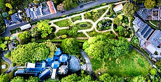
English: Candie Gardens, Guernsey |
| Date | |
| Source |
https://unsplash.com/photos/zXveFYncndo
|
| Author | Enrapture Media enrapture |
| Unsplash title | Candie Cardens in St. Peter Port, Guernsey |
| Unsplash description | A drone shot of a green park in a suburban neighbourhood |
| Categories | garden |
| EXIF | exposure_time: 1/4000 · make: DJI · iso: 500 · focal_length: 8.8 · aperture: 4.5 · model: FC6310 |
| Place | Candie Gardens, Guernsey |
| Camera location |
| View this and other nearby images on: OpenStreetMap |
|
|---|
.jpg¶ms=049.458723_N_-002.540702_E_globe:Earth_type:camera__&language=en)
Licensing

|
This image is from
Unsplash and was published
prior to 5 June 2017 under the
Creative Commons CC0 1.0 Universal Public Domain Dedication. Note: On 5 June 2017, Unsplash switched
the old sitewide license for all uploads from Creative Commons CC0 to
a custom license arrangement which does not meet the
free content licensing requirements for Commons. Therefore, media published on Unsplash from 5 June 2017 onwards is not considered to be freely licensed and can't be accepted on Commons. Files uploaded to Commons after this date should be subject to careful
license review, verifying that the publication date on Unsplash is prior to 5 June 2017.
|
| This file is made available under the Creative Commons CC0 1.0 Universal Public Domain Dedication. | |
| The person who associated a work with this deed has dedicated the work to the
public domain by waiving all of their rights to the work worldwide under copyright law, including all related and neighboring rights, to the extent allowed by law. You can copy, modify, distribute and perform the work, even for commercial purposes, all without asking permission.
|
File history
Click on a date/time to view the file as it appeared at that time.
| Date/Time | Thumbnail | Dimensions | User | Comment | |
|---|---|---|---|---|---|
| current | 14:54, 4 September 2017 |
| 8,263 × 4,241 (40.75 MB) | Fæ | Unsplash garden:11 Enrapture Media https://unsplash.com/photos/zXveFYncndo #11 |
File usage
The following pages on the English Wikipedia use this file (pages on other projects are not listed):
Global file usage
The following other wikis use this file:
- Usage on en.wikivoyage.org
- Usage on hr.wikipedia.org
Metadata
.jpg)
Size of this preview:
800 × 411 pixels. Other resolutions:
320 × 164 pixels |
640 × 328 pixels |
1,024 × 526 pixels |
1,280 × 657 pixels |
2,560 × 1,314 pixels |
8,263 × 4,241 pixels.
Original file (8,263 × 4,241 pixels, file size: 40.75 MB, MIME type: image/jpeg)
| This is a file from the
Wikimedia Commons. Information from its
description page there is shown below. Commons is a freely licensed media file repository. You can help. |
Summary
| Description |
English: Candie Gardens, Guernsey |
| Date | |
| Source |
https://unsplash.com/photos/zXveFYncndo
|
| Author | Enrapture Media enrapture |
| Unsplash title | Candie Cardens in St. Peter Port, Guernsey |
| Unsplash description | A drone shot of a green park in a suburban neighbourhood |
| Categories | garden |
| EXIF | exposure_time: 1/4000 · make: DJI · iso: 500 · focal_length: 8.8 · aperture: 4.5 · model: FC6310 |
| Place | Candie Gardens, Guernsey |
| Camera location |
| View this and other nearby images on: OpenStreetMap |
|
|---|
Licensing
|
|
This image is from
Unsplash and was published
prior to 5 June 2017 under the
Creative Commons CC0 1.0 Universal Public Domain Dedication. Note: On 5 June 2017, Unsplash switched
the old sitewide license for all uploads from Creative Commons CC0 to
a custom license arrangement which does not meet the
free content licensing requirements for Commons. Therefore, media published on Unsplash from 5 June 2017 onwards is not considered to be freely licensed and can't be accepted on Commons. Files uploaded to Commons after this date should be subject to careful
license review, verifying that the publication date on Unsplash is prior to 5 June 2017.
|
| This file is made available under the Creative Commons CC0 1.0 Universal Public Domain Dedication. | |
| The person who associated a work with this deed has dedicated the work to the
public domain by waiving all of their rights to the work worldwide under copyright law, including all related and neighboring rights, to the extent allowed by law. You can copy, modify, distribute and perform the work, even for commercial purposes, all without asking permission.
|
File history
Click on a date/time to view the file as it appeared at that time.
| Date/Time | Thumbnail | Dimensions | User | Comment | |
|---|---|---|---|---|---|
| current | 14:54, 4 September 2017 |
| 8,263 × 4,241 (40.75 MB) | Fæ | Unsplash garden:11 Enrapture Media https://unsplash.com/photos/zXveFYncndo #11 |
File usage
The following pages on the English Wikipedia use this file (pages on other projects are not listed):
Global file usage
The following other wikis use this file:
- Usage on en.wikivoyage.org
- Usage on hr.wikipedia.org