
Size of this PNG preview of this SVG file:
358 × 599 pixels. Other resolutions:
143 × 240 pixels |
287 × 480 pixels |
459 × 768 pixels |
612 × 1,024 pixels |
1,223 × 2,048 pixels |
512 × 857 pixels.
Original file (SVG file, nominally 512 × 857 pixels, file size: 741 KB)
| This is a file from the
Wikimedia Commons. Information from its
description page there is shown below. Commons is a freely licensed media file repository. You can help. |
| Description |
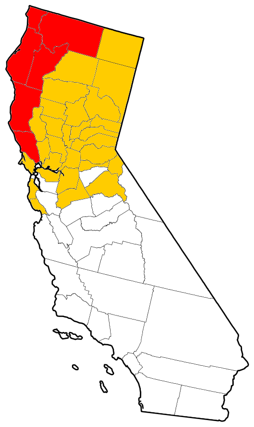
English: Vector outline map of California showing counties affected by the
Christmas flood of 1964. The thirty-four colored counties were all declared disaster areas, and the six red counties sustained more damage than the other twenty-eight combined. Derived from a United States Census publication. |
| Date | (UTC) |
| Source | |
| Author |
|
| This is a
retouched picture, which means that it has been digitally altered from its original version. Modifications: Colored for use on the
Christmas flood of 1964 article. The original can be viewed here:
California counties outline map.svg:
|
This image or file is a work of a
United States Census Bureau employee, taken or made as part of that person's official duties. As a
work of the
U.S. federal government, the image is in the
public domain.
|
 |
Original upload log
This image is a derivative work of the following images:
-
File:California_counties_outline_map.svg licensed with PD-USGov-DOC-Census
- 2009-09-17T18:30:56Z Babbage 512x857 (685516 Bytes) {{Information |Description=Vector outline map of California showing state and county borders. Derived from a US Census publication. |Source=*[[:File:California_county_map.svg|]] |Date=2009-09-17 18:28 (UTC) |Author=*[[:File:C
Uploaded with derivativeFX
File history
Click on a date/time to view the file as it appeared at that time.
| Date/Time | Thumbnail | Dimensions | User | Comment | |
|---|---|---|---|---|---|
| current | 22:07, 31 July 2011 |
| 512 × 857 (741 KB) | Little Mountain 5 | Attempt to clean up some. |
| 01:33, 29 July 2011 |
 | 512 × 857 (751 KB) | Little Mountain 5 | {{Information |Description={{en|1=Vector outline map of California showing counties affected by the Christmas flood of 1964. The thirty-four colored counties were all declared disaster areas, and the six red counties sustai |
File usage
The following pages on the English Wikipedia use this file (pages on other projects are not listed):
Global file usage
The following other wikis use this file:
- Usage on he.wikipedia.org
Size of this PNG preview of this SVG file:
358 × 599 pixels. Other resolutions:
143 × 240 pixels |
287 × 480 pixels |
459 × 768 pixels |
612 × 1,024 pixels |
1,223 × 2,048 pixels |
512 × 857 pixels.
Original file (SVG file, nominally 512 × 857 pixels, file size: 741 KB)
| This is a file from the
Wikimedia Commons. Information from its
description page there is shown below. Commons is a freely licensed media file repository. You can help. |
| Description |
English: Vector outline map of California showing counties affected by the
Christmas flood of 1964. The thirty-four colored counties were all declared disaster areas, and the six red counties sustained more damage than the other twenty-eight combined. Derived from a United States Census publication. |
| Date | (UTC) |
| Source | |
| Author |
|
| This is a
retouched picture, which means that it has been digitally altered from its original version. Modifications: Colored for use on the
Christmas flood of 1964 article. The original can be viewed here:
California counties outline map.svg:
|
This image or file is a work of a
United States Census Bureau employee, taken or made as part of that person's official duties. As a
work of the
U.S. federal government, the image is in the
public domain.
|
|
Original upload log
This image is a derivative work of the following images:
-
File:California_counties_outline_map.svg licensed with PD-USGov-DOC-Census
- 2009-09-17T18:30:56Z Babbage 512x857 (685516 Bytes) {{Information |Description=Vector outline map of California showing state and county borders. Derived from a US Census publication. |Source=*[[:File:California_county_map.svg|]] |Date=2009-09-17 18:28 (UTC) |Author=*[[:File:C
Uploaded with derivativeFX
File history
Click on a date/time to view the file as it appeared at that time.
| Date/Time | Thumbnail | Dimensions | User | Comment | |
|---|---|---|---|---|---|
| current | 22:07, 31 July 2011 |
| 512 × 857 (741 KB) | Little Mountain 5 | Attempt to clean up some. |
| 01:33, 29 July 2011 |
| 512 × 857 (751 KB) | Little Mountain 5 | {{Information |Description={{en|1=Vector outline map of California showing counties affected by the Christmas flood of 1964. The thirty-four colored counties were all declared disaster areas, and the six red counties sustai |
File usage
The following pages on the English Wikipedia use this file (pages on other projects are not listed):
Global file usage
The following other wikis use this file:
- Usage on he.wikipedia.org