
Size of this PNG preview of this SVG file:
800 × 552 pixels. Other resolutions:
320 × 221 pixels |
640 × 442 pixels |
1,024 × 707 pixels |
1,280 × 884 pixels |
2,560 × 1,768 pixels |
1,606 × 1,109 pixels.
Original file (SVG file, nominally 1,606 × 1,109 pixels, file size: 1.46 MB)
| This is a file from the
Wikimedia Commons. Information from its
description page there is shown below. Commons is a freely licensed media file repository. You can help. |
Summary
| Description | |
| Date | |
| Source | Own work |
| Author | Borysk5 |
![[3]](https://www.defense.gouv.fr/var/dicod/storage/images/base-de-medias/images/operations/rca/sangaris-breve-hebdo/140515_cartographie_rca_positions_francaises/3419624-3-fre-FR/140515_cartographie_rca_positions_francaises.jpg)
Licensing
I, the copyright holder of this work, hereby publish it under the following licenses:

|
Permission is granted to copy, distribute and/or modify this document under the terms of the GNU Free Documentation License, Version 1.2 or any later version published by the Free Software Foundation; with no Invariant Sections, no Front-Cover Texts, and no Back-Cover Texts. A copy of the license is included in the section entitled GNU Free Documentation License. |
This file is licensed under the
Creative Commons
Attribution-Share Alike 4.0 International license.
- You are free:
- to share – to copy, distribute and transmit the work
- to remix – to adapt the work
- Under the following conditions:
- attribution – You must give appropriate credit, provide a link to the license, and indicate if changes were made. You may do so in any reasonable manner, but not in any way that suggests the licensor endorses you or your use.
- share alike – If you remix, transform, or build upon the material, you must distribute your contributions under the same or compatible license as the original.
You may select the license of your choice.
File history
Click on a date/time to view the file as it appeared at that time.
| Date/Time | Thumbnail | Dimensions | User | Comment | |
|---|---|---|---|---|---|
| current | 09:38, 17 October 2020 |
| 1,606 × 1,109 (1.46 MB) | Borysk5 | Map from IPIS survey. Anti-balaka also didnt appear in Mbomou until 2017 |
| 18:22, 8 May 2020 |
 | 1,606 × 1,109 (703 KB) | Borysk5 | Minor | |
| 10:28, 30 April 2020 |
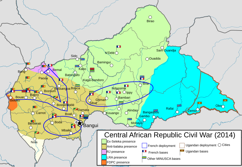
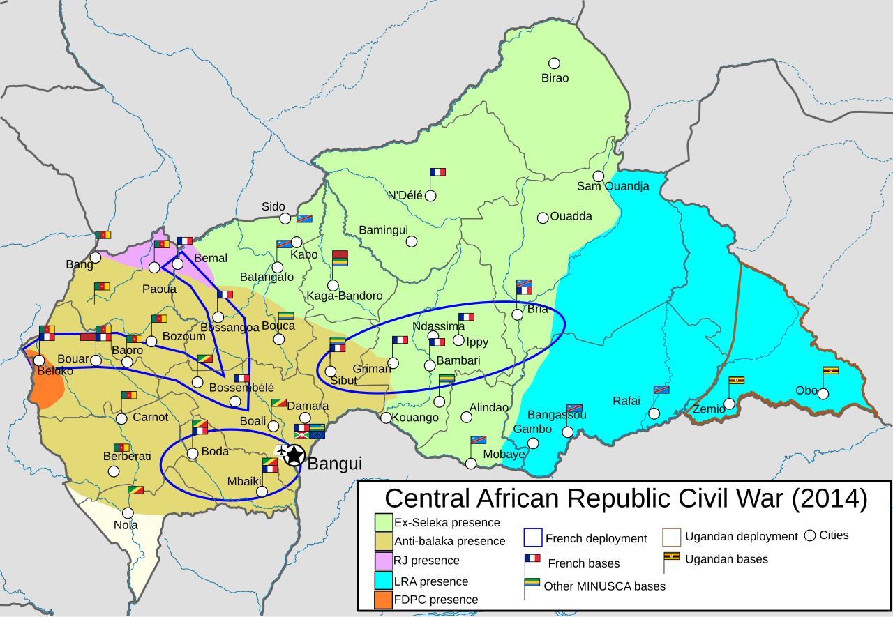
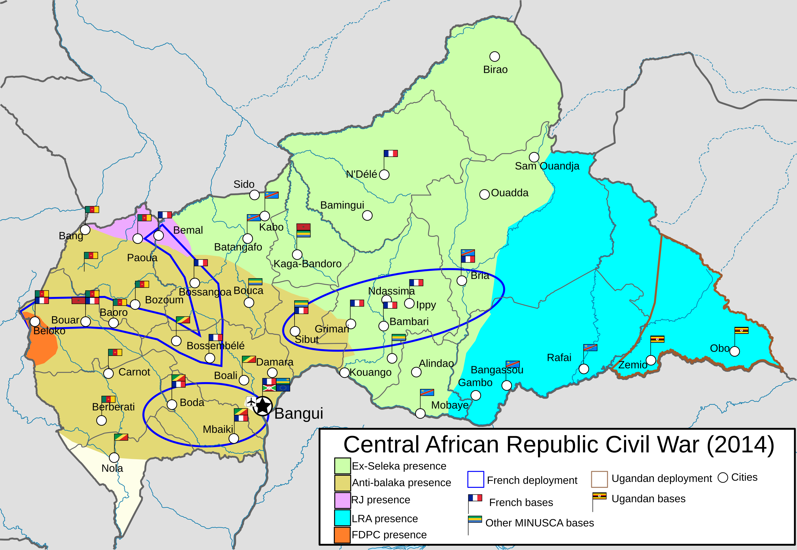
 | 1,606 × 1,109 (690 KB) | Borysk5 | {{Information |description ={{en|1=Map of control in the Central African Republic in 2014. Sources: * Timeline of the Central African Republic Civil War * [https://foreignpolicy.com/2012/08/13/let-them-hunt/] * [https://pbs.twimg.com/media/Bptvg4LIIAACyMp?format=png&name=medium] * [https://www.defense.gouv.fr/var/dicod/storage/images/base-de-medias/images/operations/rca/sangaris-breve-hebdo/140515_cartographie_rca_positions_francais... |
File usage
The following pages on the English Wikipedia use this file (pages on other projects are not listed):
Global file usage
The following other wikis use this file:
- Usage on es.wikipedia.org
Metadata
Size of this PNG preview of this SVG file:
800 × 552 pixels. Other resolutions:
320 × 221 pixels |
640 × 442 pixels |
1,024 × 707 pixels |
1,280 × 884 pixels |
2,560 × 1,768 pixels |
1,606 × 1,109 pixels.
Original file (SVG file, nominally 1,606 × 1,109 pixels, file size: 1.46 MB)
| This is a file from the
Wikimedia Commons. Information from its
description page there is shown below. Commons is a freely licensed media file repository. You can help. |
Summary
| Description | |
| Date | |
| Source | Own work |
| Author | Borysk5 |
Licensing
I, the copyright holder of this work, hereby publish it under the following licenses:
|
|
Permission is granted to copy, distribute and/or modify this document under the terms of the GNU Free Documentation License, Version 1.2 or any later version published by the Free Software Foundation; with no Invariant Sections, no Front-Cover Texts, and no Back-Cover Texts. A copy of the license is included in the section entitled GNU Free Documentation License. |
This file is licensed under the
Creative Commons
Attribution-Share Alike 4.0 International license.
- You are free:
- to share – to copy, distribute and transmit the work
- to remix – to adapt the work
- Under the following conditions:
- attribution – You must give appropriate credit, provide a link to the license, and indicate if changes were made. You may do so in any reasonable manner, but not in any way that suggests the licensor endorses you or your use.
- share alike – If you remix, transform, or build upon the material, you must distribute your contributions under the same or compatible license as the original.
You may select the license of your choice.
File history
Click on a date/time to view the file as it appeared at that time.
| Date/Time | Thumbnail | Dimensions | User | Comment | |
|---|---|---|---|---|---|
| current | 09:38, 17 October 2020 |
| 1,606 × 1,109 (1.46 MB) | Borysk5 | Map from IPIS survey. Anti-balaka also didnt appear in Mbomou until 2017 |
| 18:22, 8 May 2020 |
| 1,606 × 1,109 (703 KB) | Borysk5 | Minor | |
| 10:28, 30 April 2020 |
| 1,606 × 1,109 (690 KB) | Borysk5 | {{Information |description ={{en|1=Map of control in the Central African Republic in 2014. Sources: * Timeline of the Central African Republic Civil War * [https://foreignpolicy.com/2012/08/13/let-them-hunt/] * [https://pbs.twimg.com/media/Bptvg4LIIAACyMp?format=png&name=medium] * [https://www.defense.gouv.fr/var/dicod/storage/images/base-de-medias/images/operations/rca/sangaris-breve-hebdo/140515_cartographie_rca_positions_francais... |
File usage
The following pages on the English Wikipedia use this file (pages on other projects are not listed):
Global file usage
The following other wikis use this file:
- Usage on es.wikipedia.org