
Original file (3,264 × 2,448 pixels, file size: 797 KB, MIME type: image/jpeg)
| This is a file from the
Wikimedia Commons. Information from its
description page there is shown below. Commons is a freely licensed media file repository. You can help. |
Summary
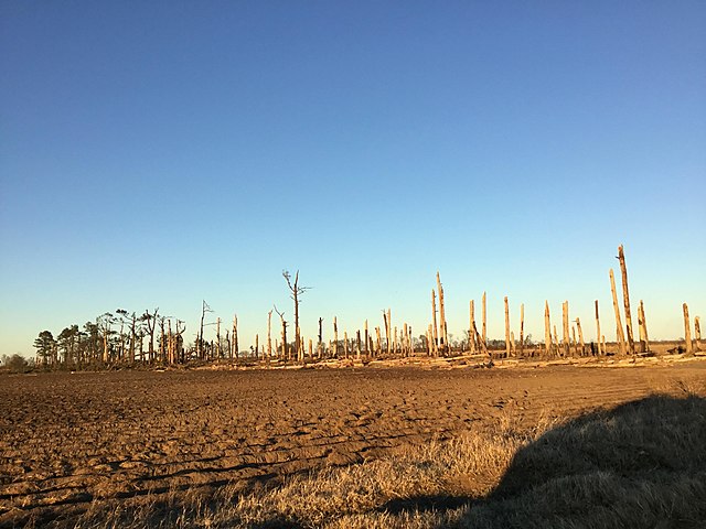
| Description | Trees that were completely debarked and denuded near Buckeye, Arkansas. |
| Date | |
| Source | https://services.dat.noaa.gov/arcgis/rest/services/nws_damageassessmenttoolkit/DamageViewer/FeatureServer/0/2562892/attachments/1575920 |
| Author | NWS Memphis |
| Permission ( Reusing this file) |
National Weather Service |
| Camera location | | View this and other nearby images on: OpenStreetMap |
|
|---|
Licensing
This image is in the
public domain because it was stored on the web servers of the U.S.
National Weather Service. NWS-created images are automatically public domain in the U.S. since the NWS is a part of the U.S. government. However, the NWS sites also host non-NWS images which have been submitted by individuals: these are generally shown as "Courtesy of ...". Such images have explicitly been released to the public domain by the copyright owner as part of the upload process.
As stated at https://www.weather.gov/fsd/disclaimer: "By submitting images, you understand that your image is being released into the public domain. This means that your photo or video may be downloaded, copied, and used by others." Thus, all* images on NWS servers are public domain (including "Courtesy of ..." and “Photo by ...” images) unless specifically stated otherwise through a copyright (©) watermark.
*A
deletion discussion in November 2023 ruled that
Getty Images on the web servers of NWS, are to be considered copyrighted, even without a copyright (©) watermark and are the
sole exception to this rule.
|

|
This media file is uncategorized.
Please help improve this media file by adding it to one or more categories, so it may be associated with related media files (
how?), and so that it can be more easily found.
Please notify the uploader with {{subst:Please link images|File:Buckeyedebarking.jpg}} ~~~~ |
File history
Click on a date/time to view the file as it appeared at that time.
| Date/Time | Thumbnail | Dimensions | User | Comment | |
|---|---|---|---|---|---|
| current | 07:37, 29 December 2021 |
| 3,264 × 2,448 (797 KB) | TornadoInformation12 | {{Information |Description= Trees that were completely debarked and denuded near Buckeye, Arkansas. |Source=https://services.dat.noaa.gov/arcgis/rest/services/nws_damageassessmenttoolkit/DamageViewer/FeatureServer/0/2562892/attachments/1575920 |Date=December 11, 2021 |Author=NWS Memphis |Permission=National Weather Service |other_versions= }} |
File usage
Metadata
Original file (3,264 × 2,448 pixels, file size: 797 KB, MIME type: image/jpeg)
| This is a file from the
Wikimedia Commons. Information from its
description page there is shown below. Commons is a freely licensed media file repository. You can help. |
Summary
| Description | Trees that were completely debarked and denuded near Buckeye, Arkansas. |
| Date | |
| Source | https://services.dat.noaa.gov/arcgis/rest/services/nws_damageassessmenttoolkit/DamageViewer/FeatureServer/0/2562892/attachments/1575920 |
| Author | NWS Memphis |
| Permission ( Reusing this file) |
National Weather Service |
| Camera location | | View this and other nearby images on: OpenStreetMap |
|
|---|
Licensing
This image is in the
public domain because it was stored on the web servers of the U.S.
National Weather Service. NWS-created images are automatically public domain in the U.S. since the NWS is a part of the U.S. government. However, the NWS sites also host non-NWS images which have been submitted by individuals: these are generally shown as "Courtesy of ...". Such images have explicitly been released to the public domain by the copyright owner as part of the upload process.
As stated at https://www.weather.gov/fsd/disclaimer: "By submitting images, you understand that your image is being released into the public domain. This means that your photo or video may be downloaded, copied, and used by others." Thus, all* images on NWS servers are public domain (including "Courtesy of ..." and “Photo by ...” images) unless specifically stated otherwise through a copyright (©) watermark.
*A
deletion discussion in November 2023 ruled that
Getty Images on the web servers of NWS, are to be considered copyrighted, even without a copyright (©) watermark and are the
sole exception to this rule.
|
|
|
This media file is uncategorized.
Please help improve this media file by adding it to one or more categories, so it may be associated with related media files (
how?), and so that it can be more easily found.
Please notify the uploader with {{subst:Please link images|File:Buckeyedebarking.jpg}} ~~~~ |
File history
Click on a date/time to view the file as it appeared at that time.
| Date/Time | Thumbnail | Dimensions | User | Comment | |
|---|---|---|---|---|---|
| current | 07:37, 29 December 2021 |
| 3,264 × 2,448 (797 KB) | TornadoInformation12 | {{Information |Description= Trees that were completely debarked and denuded near Buckeye, Arkansas. |Source=https://services.dat.noaa.gov/arcgis/rest/services/nws_damageassessmenttoolkit/DamageViewer/FeatureServer/0/2562892/attachments/1575920 |Date=December 11, 2021 |Author=NWS Memphis |Permission=National Weather Service |other_versions= }} |