
Size of this PNG preview of this SVG file:
343 × 600 pixels. Other resolutions:
137 × 240 pixels |
274 × 480 pixels |
439 × 768 pixels |
586 × 1,024 pixels |
1,171 × 2,048 pixels |
675 × 1,180 pixels.
Original file (SVG file, nominally 675 × 1,180 pixels, file size: 142 KB)
| This is a file from the
Wikimedia Commons. Information from its
description page there is shown below. Commons is a freely licensed media file repository. You can help. |
Summary
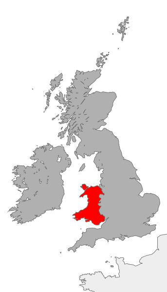
| Description | Map showing the area of Wales in relation to Great Britain and Ireland |
| Date | |
| Source | Own work |
| Author | Cnbrb |
Licensing
| I, the copyright holder of this work, release this work into the
public domain. This applies worldwide. In some countries this may not be legally possible; if so: I grant anyone the right to use this work for any purpose, without any conditions, unless such conditions are required by law. |
File history
Click on a date/time to view the file as it appeared at that time.
| Date/Time | Thumbnail | Dimensions | User | Comment | |
|---|---|---|---|---|---|
| current | 18:42, 20 October 2007 |
| 675 × 1,180 (142 KB) | Cnbrb | == Summary == {{Information |Description=map showing the area of Wales in relation to Great Britain and Ireland |Source=self-made |Date=2007-20-09 |Author= Cnbrb }} Category:Locator maps of countries of the United Kingdom [[Category:Ma |
File usage
The following pages on the English Wikipedia use this file (pages on other projects are not listed):
Global file usage
The following other wikis use this file:
- Usage on ast.wiktionary.org
- Usage on cs.wikipedia.org
- Usage on de.wikipedia.org
- Usage on es.wikipedia.org
- Usage on hu.wikipedia.org
- Usage on id.wikipedia.org
- Usage on it.wikipedia.org
- Usage on ja.wikipedia.org
- Usage on ro.wikipedia.org
- Usage on ru.wikipedia.org
- Usage on ru.wiktionary.org
- Usage on tr.wikipedia.org
- Usage on uk.wikipedia.org
- Usage on zh.wikipedia.org
Size of this PNG preview of this SVG file:
343 × 600 pixels. Other resolutions:
137 × 240 pixels |
274 × 480 pixels |
439 × 768 pixels |
586 × 1,024 pixels |
1,171 × 2,048 pixels |
675 × 1,180 pixels.
Original file (SVG file, nominally 675 × 1,180 pixels, file size: 142 KB)
| This is a file from the
Wikimedia Commons. Information from its
description page there is shown below. Commons is a freely licensed media file repository. You can help. |
Summary
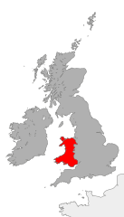
| Description | Map showing the area of Wales in relation to Great Britain and Ireland |
| Date | |
| Source | Own work |
| Author | Cnbrb |
Licensing
| I, the copyright holder of this work, release this work into the
public domain. This applies worldwide. In some countries this may not be legally possible; if so: I grant anyone the right to use this work for any purpose, without any conditions, unless such conditions are required by law. |
File history
Click on a date/time to view the file as it appeared at that time.
| Date/Time | Thumbnail | Dimensions | User | Comment | |
|---|---|---|---|---|---|
| current | 18:42, 20 October 2007 |
| 675 × 1,180 (142 KB) | Cnbrb | == Summary == {{Information |Description=map showing the area of Wales in relation to Great Britain and Ireland |Source=self-made |Date=2007-20-09 |Author= Cnbrb }} Category:Locator maps of countries of the United Kingdom [[Category:Ma |
File usage
The following pages on the English Wikipedia use this file (pages on other projects are not listed):
Global file usage
The following other wikis use this file:
- Usage on ast.wiktionary.org
- Usage on cs.wikipedia.org
- Usage on de.wikipedia.org
- Usage on es.wikipedia.org
- Usage on hu.wikipedia.org
- Usage on id.wikipedia.org
- Usage on it.wikipedia.org
- Usage on ja.wikipedia.org
- Usage on ro.wikipedia.org
- Usage on ru.wikipedia.org
- Usage on ru.wiktionary.org
- Usage on tr.wikipedia.org
- Usage on uk.wikipedia.org
- Usage on zh.wikipedia.org