
Size of this PNG preview of this SVG file:
481 √ó 599 pixels. Other resolutions:
192 √ó 240 pixels |
385 √ó 480 pixels |
616 √ó 768 pixels |
822 √ó 1,024 pixels |
1,643 √ó 2,048 pixels |
1,450 √ó 1,807 pixels.
Original file (SVG file, nominally 1,450 √ó 1,807 pixels, file size: 681 KB)
| This is a file from the
Wikimedia Commons. Information from its
description page there is shown below. Commons is a freely licensed media file repository. You can help. |
Summary
| Description |
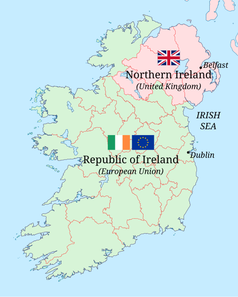
English: Frontier between the United Kingdom and the European Union in Ireland after 31st January 2020: the Republic of Ireland in green and Northern Ireland in pink, with the British flag in Northern Ireland and the flag of Europe and the flag of Ireland in the Republic. The international border is now also the frontier of the European Union and the European Economic Area. |
| Date | |
| Source |
This file was derived from: |
| Author |
Own work based on:
Counties of Ireland.svg:
|
| Other versions |
|
.svg)
.svg)
.svg)
Licensing
This file is licensed under the
Creative Commons
Attribution-Share Alike 4.0 International license.
- You are free:
- to share ‚Äď to copy, distribute and transmit the work
- to remix ‚Äď to adapt the work
- Under the following conditions:
- attribution ‚Äď You must give appropriate credit, provide a link to the license, and indicate if changes were made. You may do so in any reasonable manner, but not in any way that suggests the licensor endorses you or your use.
- share alike ‚Äď If you remix, transform, or build upon the material, you must distribute your contributions under the same or compatible license as the original.
File history
Click on a date/time to view the file as it appeared at that time.
| Date/Time | Thumbnail | Dimensions | User | Comment | |
|---|---|---|---|---|---|
| current | 18:35, 31 October 2021 |
| 1,450 √ó 1,807 (681 KB) | GPinkerton | Smaller flags |
| 15:44, 31 October 2021 |
 | 1,450 √ó 1,807 (685 KB) | GPinkerton | Add labels and Irish tricolour | |
| 16:59, 28 October 2021 |
 | 1,450 √ó 1,807 (703 KB) | GPinkerton | Uploaded a work by {{Own based|Ireland and Ulster, counties.svg|Flag of the United Kingdom (2-3).svg|Flag of Europe.svg|display=24}} from {{Derived from|Ireland and Ulster, counties.svg|Flag of the United Kingdom (2-3).svg|Flag of Europe.svg|display = 16 | opt = l}} with UploadWizard |
File usage
The following pages on the English Wikipedia use this file (pages on other projects are not listed):
Global file usage
The following other wikis use this file:
- Usage on ca.wikipedia.org
- Usage on cs.wikipedia.org
- Usage on eu.wikipedia.org
- Usage on fi.wikipedia.org
- Usage on pt.wikipedia.org
- Usage on www.wikidata.org
Metadata
Size of this PNG preview of this SVG file:
481 √ó 599 pixels. Other resolutions:
192 √ó 240 pixels |
385 √ó 480 pixels |
616 √ó 768 pixels |
822 √ó 1,024 pixels |
1,643 √ó 2,048 pixels |
1,450 √ó 1,807 pixels.
Original file (SVG file, nominally 1,450 √ó 1,807 pixels, file size: 681 KB)
| This is a file from the
Wikimedia Commons. Information from its
description page there is shown below. Commons is a freely licensed media file repository. You can help. |
Summary
| Description |
English: Frontier between the United Kingdom and the European Union in Ireland after 31st January 2020: the Republic of Ireland in green and Northern Ireland in pink, with the British flag in Northern Ireland and the flag of Europe and the flag of Ireland in the Republic. The international border is now also the frontier of the European Union and the European Economic Area. |
| Date | |
| Source |
This file was derived from: |
| Author |
Own work based on:
Counties of Ireland.svg:
|
| Other versions |
|
Licensing
This file is licensed under the
Creative Commons
Attribution-Share Alike 4.0 International license.
- You are free:
- to share ‚Äď to copy, distribute and transmit the work
- to remix ‚Äď to adapt the work
- Under the following conditions:
- attribution ‚Äď You must give appropriate credit, provide a link to the license, and indicate if changes were made. You may do so in any reasonable manner, but not in any way that suggests the licensor endorses you or your use.
- share alike ‚Äď If you remix, transform, or build upon the material, you must distribute your contributions under the same or compatible license as the original.
File history
Click on a date/time to view the file as it appeared at that time.
| Date/Time | Thumbnail | Dimensions | User | Comment | |
|---|---|---|---|---|---|
| current | 18:35, 31 October 2021 |
| 1,450 √ó 1,807 (681 KB) | GPinkerton | Smaller flags |
| 15:44, 31 October 2021 |
| 1,450 √ó 1,807 (685 KB) | GPinkerton | Add labels and Irish tricolour | |
| 16:59, 28 October 2021 |
| 1,450 √ó 1,807 (703 KB) | GPinkerton | Uploaded a work by {{Own based|Ireland and Ulster, counties.svg|Flag of the United Kingdom (2-3).svg|Flag of Europe.svg|display=24}} from {{Derived from|Ireland and Ulster, counties.svg|Flag of the United Kingdom (2-3).svg|Flag of Europe.svg|display = 16 | opt = l}} with UploadWizard |
File usage
The following pages on the English Wikipedia use this file (pages on other projects are not listed):
Global file usage
The following other wikis use this file:
- Usage on ca.wikipedia.org
- Usage on cs.wikipedia.org
- Usage on eu.wikipedia.org
- Usage on fi.wikipedia.org
- Usage on pt.wikipedia.org
- Usage on www.wikidata.org