Size of this preview:
800 × 533 pixels. Other resolutions:
320 × 213 pixels |
640 × 427 pixels.
Original file (900 × 600 pixels, file size: 443 KB, MIME type: image/jpeg)
| This is a file from the
Wikimedia Commons. Information from its
description page there is shown below. Commons is a freely licensed media file repository. You can help. |
Summary
| Description |
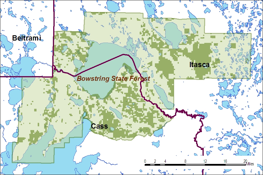
English: Map of Bowstring State Forest, showing boundary and state forest lands (dark green). |
| Date | 12 December 2010 (original upload date) |
| Source | Transferred from en.wikipedia by SreeBot |
| Author | Minn-rox at en.wikipedia |
Licensing
| This work has been released into the
public domain by its author,
Minn-rox at
English Wikipedia. This applies worldwide. In some countries this may not be legally possible; if so: Minn-rox grants anyone the right to use this work for any purpose, without any conditions, unless such conditions are required by law. |
Original upload log
The original description page was
here. All following user names refer to en.wikipedia.
Upload date | User | Bytes | Dimensions | Comment
- 2010-12-13 14:52 (UTC) | Minn-rox | 453831 (bytes) | 900×600 | Reverted to version as of 14:48, 13 December 2010
- 2010-12-13 14:50 (UTC) | Minn-rox | 453831 (bytes) | 900×600 | Reverted to version as of 14:46, 13 December 2010
- 2010-12-13 14:48 (UTC) | Minn-rox | 453831 (bytes) | 900×600 | {{PD-self}}
- 2010-12-13 14:46 (UTC) | Minn-rox | 453831 (bytes) | 900×600 | Added information on property ownership.
- 2010-12-12 19:39 (UTC) | Minn-rox | 382120 (bytes) | 900×600 | Map of Bowstring State Forest boundaries
File history
Click on a date/time to view the file as it appeared at that time.
| Date/Time | Thumbnail | Dimensions | User | Comment | |
|---|---|---|---|---|---|
| current | 08:56, 24 September 2011 |
| 900 × 600 (443 KB) | SreeBot | (Original text) : Reverted to version as of 14:48, 13 December 2010 |
| 08:56, 24 September 2011 |
 | 900 × 600 (443 KB) | SreeBot | (Original text) : Reverted to version as of 14:46, 13 December 2010 | |
| 08:56, 24 September 2011 |
 | 900 × 600 (443 KB) | SreeBot | (Original text) : {{PD-self}} | |
| 08:56, 24 September 2011 |
 | 900 × 600 (443 KB) | SreeBot | (Original text) : Added information on property ownership. | |
| 08:56, 24 September 2011 |
 | 900 × 600 (373 KB) | SreeBot | (Original text) : Map of Bowstring State Forest boundaries |
File usage
The following pages on the English Wikipedia use this file (pages on other projects are not listed):
Metadata
Size of this preview:
800 × 533 pixels. Other resolutions:
320 × 213 pixels |
640 × 427 pixels.
Original file (900 × 600 pixels, file size: 443 KB, MIME type: image/jpeg)
| This is a file from the
Wikimedia Commons. Information from its
description page there is shown below. Commons is a freely licensed media file repository. You can help. |
Summary
| Description |
English: Map of Bowstring State Forest, showing boundary and state forest lands (dark green). |
| Date | 12 December 2010 (original upload date) |
| Source | Transferred from en.wikipedia by SreeBot |
| Author | Minn-rox at en.wikipedia |
Licensing
| This work has been released into the
public domain by its author,
Minn-rox at
English Wikipedia. This applies worldwide. In some countries this may not be legally possible; if so: Minn-rox grants anyone the right to use this work for any purpose, without any conditions, unless such conditions are required by law. |
Original upload log
The original description page was
here. All following user names refer to en.wikipedia.
Upload date | User | Bytes | Dimensions | Comment
- 2010-12-13 14:52 (UTC) | Minn-rox | 453831 (bytes) | 900×600 | Reverted to version as of 14:48, 13 December 2010
- 2010-12-13 14:50 (UTC) | Minn-rox | 453831 (bytes) | 900×600 | Reverted to version as of 14:46, 13 December 2010
- 2010-12-13 14:48 (UTC) | Minn-rox | 453831 (bytes) | 900×600 | {{PD-self}}
- 2010-12-13 14:46 (UTC) | Minn-rox | 453831 (bytes) | 900×600 | Added information on property ownership.
- 2010-12-12 19:39 (UTC) | Minn-rox | 382120 (bytes) | 900×600 | Map of Bowstring State Forest boundaries
File history
Click on a date/time to view the file as it appeared at that time.
| Date/Time | Thumbnail | Dimensions | User | Comment | |
|---|---|---|---|---|---|
| current | 08:56, 24 September 2011 |
| 900 × 600 (443 KB) | SreeBot | (Original text) : Reverted to version as of 14:48, 13 December 2010 |
| 08:56, 24 September 2011 |
| 900 × 600 (443 KB) | SreeBot | (Original text) : Reverted to version as of 14:46, 13 December 2010 | |
| 08:56, 24 September 2011 |
| 900 × 600 (443 KB) | SreeBot | (Original text) : {{PD-self}} | |
| 08:56, 24 September 2011 |
| 900 × 600 (443 KB) | SreeBot | (Original text) : Added information on property ownership. | |
| 08:56, 24 September 2011 |
| 900 × 600 (373 KB) | SreeBot | (Original text) : Map of Bowstring State Forest boundaries |
File usage
The following pages on the English Wikipedia use this file (pages on other projects are not listed):